Piute Valley

Last updated
Piute Valley
Piute Range from Piute Valley 2.jpg
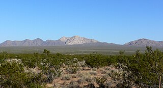
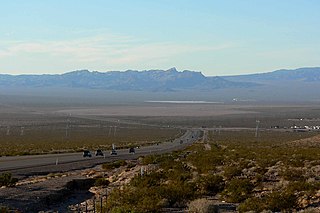
View west over the middle Piute Valley, Piute Range in distance
Relief map of California.png
Red pog.svg
Piute Valley
Piute Valley
in Nevada and California
Length 45 mi (72 km)N-S
Width 10 mi (16 km)E-W
Geography
Country United States
States Nevada and California
Regions Mojave Desert, Mojave National Preserve and Lower Colorado River Valley
Districts Clark County, NV and San Bernardino County, CA
Population centers Cal-Nev-Ari, NV and Searchlight, NV
Borders on Piute Range, Newberry Mountains (Nevada), Dead Mountains and Interstate 40 in California
Coordinates 35°18′12″N114°52′51″W / 35.30333°N 114.88083°W / 35.30333; -114.88083 Coordinates: 35°18′12″N114°52′51″W / 35.30333°N 114.88083°W / 35.30333; -114.88083
River Piute Wash

The Piute Valley is a 45-mile-long (72 km) north–south valley southeast of Las Vegas, Nevada, and northwest of Needles. The north of the valley is at Searchlight, with some of the valley extending northwest from Searchlight. At the center-north lies Cal-Nev-Ari, Nevada.

Needles, California City in California in the United States

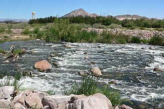
Needles is a city in eastern San Bernardino County, California, United States. It lies on the western banks of the Colorado River in the Mohave Valley subregion of the Mojave Desert, near the borders of Arizona and Nevada and roughly 110 miles (180 km) from the Las Vegas Strip. It is the easternmost city of the San Bernardino-Riverside metropolitan area. Needles is geographically isolated from other cities in the county. Barstow, the nearest city within the county, is separated from Needles by over 140 miles of desert and 2 mountain ranges. The city is accessible via Interstate 40 and U.S. Route 95. The population was 4,844 at the 2010 census, up from 4,830 at the 2000 census.

Searchlight, Nevada Unincorporated town in Nevada, United States

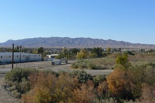
Searchlight is an unincorporated town and census-designated place (CDP) in Clark County, Nevada, United States, at the topographic saddle between two mountain ranges. As of the 2010 census it had a population of 539.

Cal-Nev-Ari, Nevada Census-designated place in Nevada, United States

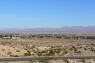
Cal-Nev-Ari is a census-designated place on U.S. Route 95 in Clark County, Nevada, United States, near the state's southernmost point. As of the 2010 census, the town had a population of 244. The town's name is a syllabic abbreviation of California, Nevada, and Arizona.

Contents

The second valley southeast of Las Vegas borders to the north, the endorheic Eldorado Valley, with its dry lake. The next watershed north is the Las Vegas Wash Watershed.

Eldorado Valley valley in Nevada, United States of America

Eldorado Valley, or El Dorado Valley, is a Great Basin valley in the Mojave Desert southeast of Las Vegas and southwest of Boulder City, Nevada. The valley is endorheic, containing the Eldorado Dry Lake. The Great Basin Divide, transects ridgelines and saddles, on the north, northeast, east, and south around the valley, as the valley sits on the east of the McCullough Range, a Great Basin massif, on the Great Basin Divide at its north terminus and its south terminus.

Dry lake A basin or depression that formerly contained a standing surface water body

A dry lake is either a basin or depression that formerly contained a standing surface water body, which disappeared when evaporation processes exceeded recharge. If the floor of a dry lake is covered by deposits of alkaline compounds, it is known as an alkali flat. If covered with salt, it is known as a salt flat.

Las Vegas Wash channel which feeds most of the Las Vegas Valleys excess water into Lake Mead

Las Vegas Wash is a 12-mile-long channel which feeds most of the Las Vegas Valley's excess water into Lake Mead. The wash is sometimes called an urban river, and it exists in its present capacity because of an urban population. The wash also works in a systemic conjunction with the pre-existing wetlands that formed the oasis of the Las Vegas Valley. The wash is fed by urban runoff, shallow ground water, reclaimed water, and stormwater.

The northeast portion of the Mojave National Preserve makes up the northwestern region of the Piute Valley, at a four-valley water divide point.

Mojave National Preserve

Mojave National Preserve is a United States National Preserve located in the Mojave Desert of San Bernardino County, California, USA, between Interstate 15 and Interstate 40. The preserve was established October 31, 1994, with the passage of the California Desert Protection Act by the US Congress. Previously, it was the East Mojave National Scenic Area, under the jurisdiction of the Bureau of Land Management. Mojave National Preserve is vast. At 1,600,000 acres (650,000 ha), it is the third largest unit of the National Park System in the contiguous United States.

The Piute Valley Watershed [1] is the first watershed southeast of Las Vegas Lake Mead to meet the Colorado River; the Piute Wash outfall with the Colorado River is in California at Needles. The mountain ranges south of Lake Mead, bordering the river and Lake Mohave are part of the Havasu-Mohave Lakes Watershed. [2]

Lake Mead reservoir on the Colorado River in the U.S. states of Nevada and Arizona

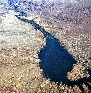
Lake Mead is a man made lake that lies on the Colorado River, about 24 mi (39 km) from the Las Vegas Strip, southeast of the city of Las Vegas, Nevada, in the states of Nevada and Arizona. It is the largest reservoir in the United States in terms of water capacity. Formed by the Hoover Dam on September 30, 1935, the reservoir serves water to the states of Arizona, California, and Nevada, as well as some of Mexico, providing sustenance to nearly 20 million people and large areas of farmland.

Piute Wash

The Piute Wash of extreme southeastern Nevada and northeast San Bernardino County California is the south-flowing drainage of the Piute Valley. The wash and valley are located northwest of Needles, California.

California State of the United States of America

California is a state in the Pacific Region of the United States. With 39.6 million residents, California is the most populous U.S. state and the third-largest by area. The state capital is Sacramento. The Greater Los Angeles Area and the San Francisco Bay Area are the nation's second- and fifth-most populous urban regions, with 18.7 million and 9.7 million residents respectively. Los Angeles is California's most populous city, and the country's second-most populous, after New York City. California also has the nation's most populous county, Los Angeles County, and its largest county by area, San Bernardino County. The City and County of San Francisco is both the country's second-most densely populated major city after New York City and the fifth-most densely populated county, behind only four of the five New York City boroughs.

Piute Valley description

Piute Valley is a 45-mile-long (72 km) valley, and about 10 miles (16 km) wide at its southern end. It is drained by Piute Wash with the wash turning easterly at the south to join the Colorado River at Needles. The valley is bordered by three mountain ranges, all north–south ranges, with the Piute Range to the west. To the northeast is the Newberry Mountains, and to the southeast is the Dead Mountains range, where Piute Wash borders its southwest and south perimeter.

Colorado River major river in the western United States and Mexico

The Colorado River is one of the principal rivers in the Southwestern United States and northern Mexico. The 1,450-mile-long (2,330 km) river drains an expansive, arid watershed that encompasses parts of seven U.S. and two Mexican states. Starting in the central Rocky Mountains of Colorado, the river flows generally southwest across the Colorado Plateau and through the Grand Canyon before reaching Lake Mead on the Arizona–Nevada border, where it turns south toward the international border. After entering Mexico, the Colorado approaches the mostly dry Colorado River Delta at the tip of the Gulf of California between Baja California and Sonora.

Piute Range

The Piute Range is located in the Mojave Desert, primarily in northeast San Bernardino County, California, United States, with a north portion in Nevada. Most of the range is the eastern border of the Mojave National Preserve, a National Park Service natural area and park.

Newberry Mountains (Nevada)

The Newberry Mountains in Nevada are located east of Cal-Nev-Ari and the United States Coast Guard LORAN station in the southern part of the state. The range is Nevada's southernmost named mountain range, and lies to the northwest of the town of Laughlin and west of Lake Mohave. The Newberry Mountains connect with the Eldorado Mountains and The Highland Mountains.

Searchlight is at the north of the valley, with a 5-mile (8.0 km) grade of U.S. Route 95 in Nevada north of Searchlight to the beginning of the Eldorado Valley. U.S. 95 is the route traversing the Piute Valley north–south, connecting at the south to the east–west Interstate 40 in California and the northern foothills of the Sacramento Mountains.

U.S. Route 95 in Nevada highway in Nevada

U.S. Route 95 is a major U.S. highway traversing the U.S. state of Nevada from north to south directly through Las Vegas and providing connections to both Carson City and Reno. US 95 is cosigned with Interstate 80 for 95 miles (153 km) between a junction in Churchill County and Winnemucca before heading north into Oregon at McDermitt.

In the State of California, Interstate 40 (I-40) begins on the west at its interchange with Interstate 15 in Barstow. Sometimes called the Needles Freeway, it is a major east–west highway of the Interstate Highway System that goes all the way to Wilmington, North Carolina. I-40 goes east from Barstow across the Mojave Desert in San Bernardino County past the Clipper Mountains to Needles, before it crosses over the Colorado River into Arizona east of Needles. All 155 miles of I-40 in California are in San Bernardino County.

Sacramento Mountains (California)

The Sacramento Mountains are a mountain range in the Eastern Mojave Desert and within Mojave Trails National Monument, in San Bernardino County, California.

4-Valley water divide, endorheic Mohave National Preserve

Central-northern Piute Valley, Cal-Nev-Ari, Nevada -- the north mountain ranges and valleys water divide point is at right in the distance -- the spires on the right, 3rd range, are the Castle Peaks of the New York Mountains
(View from Spirit Mountain) Cal-Nev-Ari Nevada from Spirit Mountain 1.jpg
Central-northern Piute Valley, Cal-Nev-Ari, Nevada — the north mountain ranges and valleys water divide point is at right in the distance the spires on the right, 3rd range, are the Castle Peaks of the New York Mountains
(View from Spirit Mountain)

The southern end of the extensive McCullough Range converges with four valleys and three mountain ranges. West of the McCullough's lie the endorheic Roach and Ivanpah Dry Lakes of Ivanpah Valley; the valley extends north into Las Vegas' southwest, a tributary to the Las Vegas Wash. Ivanpah Valley turns southeast to meet the water divide point. Northeast of the water divide point is the southwest Eldorado Valley, also endorheic with its Eldorado Dry Lake. Southwest the Piute Valley drains south, then Piute Wash turns east and descends steeply at the Dead Mountains to its outfall at the Colorado River and Needles.

The Mojave National Preserve is mostly endorheic with the west bordering on Baker, California, and the twin dry lakes of Silver Dry Lake and Soda Dry Lake. The northeast preserve corner is anchored by the water divide point. The northeast borders of the New York and smaller Castle Mountains meet the north of the Piute Range; to the west of the Piute's, east of the New York Mountains is the southerly draining endorheic Lanfair Valley.

The Piute Valley Watershed is the first major watershed southeast of Las Vegas to drain into the western side of the south-flowing Colorado River.

Though Piute Wash drains Piute Valley, the entire watershed includes Sacramento Wash (California) which covers an equivalent area west of the north–south Piute Range, and drains the Lanfair Valley and surrounding mountain ranges.

Related Research Articles

Mohave Valley valley in Arizona, United States of America

The Mohave Valley is a valley located mostly on the east shore of the south-flowing Colorado River in northwest Arizona. The valley extends into California's San Bernardino County; the northern side of the valley extends into extreme southeast Clark County, Nevada. The main part of the valley lies in southwest Mohave County, Arizona and is at the intersection of the southeast Mojave and northwest Sonoran deserts.

New York Mountains Small mountain range in San Bernadino County, California

The New York Mountains are a small mountain range found in northeastern San Bernardino County in California, USA. The range's northeastern area lies in southeastern Nevada. The range lies just south of the small community of Ivanpah, and north of the Lanfair Valley. The mountains are part of the mountain ranges, cones, mountains, and landforms in the Mojave National Preserve. The mountains reach an elevation of 7,533 feet (2,296 m), and run in a mostly southwest-northeasterly direction between the Providence Mountains and the McCullough Range approximately five miles into Nevada and border the northwest corner of the Piute Valley of Nevada-California.

Lanfair Valley valley in San Bernardino County, United States of America

Lanfair Valley is located in the Mojave Desert in southeastern California near the Nevada state line. It is bounded on the north by the New York Mountains and Castle Mountains, on the east by the Piute Range, and on the south by the Woods Mountains and Vontrigger Hills. Joshua Trees can be found in most of the valley. Elevation is 4,045 feet.

The Ivanpah Valley is in southeastern California and southern Nevada in the United States. The valley is between the New York Mountains and the Ivanpah Mountains in San Bernardino County on the California side, and in Clark County on the Nevada side. The communities of Cima, California; Nipton, California; Jean, Nevada; and Primm, Nevada are in the valley. The Ivanpah Dry Lake, a popular place for land sailing, and the site of the proposed Ivanpah Valley Airport also lie in the valley.

Black Mountains (Arizona)

The Black Mountains of northwest Arizona are an extensive, mostly linear, north-south 75-mile (121 km) long mountain range. It forms the north-south border of southwest Mohave County as it borders the eastern shore of the south-flowing Colorado River from Hoover Dam.

Eldorado Mountains

The Eldorado Mountains, also called the El Dorado Mountains, are a north-south trending mountain range in southeast Nevada bordering west of the south-flowing Colorado River; the endorheic Eldorado Valley borders the range to the west, and the range is also on the western border of the Colorado River's Black Canyon of the Colorado, and El Dorado Canyon on the river. The range is 50 miles (80 km) southeast of Las Vegas, Nevada; and the Eldorado Mountains connect with the Highland and Newberry mountains.

Sacramento Wash

The Sacramento Wash is a major drainage of northwest Arizona in Mohave County. The wash is east of the Black Canyon of the Colorado and drains into the south-flowing Colorado River 45 mi south of Lake Mohave, and 90 mi south of Hoover Dam at Lake Mead. The wash outfall is in the center-south of the Havasu-Mohave Lakes Watershed. An equivalent wash drains to the west of the Colorado River and the Black Canyon, draining southeast Nevada and a small part of California, the Piute Wash of the Piute Valley. The Piute Wash outfall is upstream of the Sacramento's outfall by about 15 miles.

Mohave Mountains

The Mohave Mountains are a small 18-mi (29 km) long mountain range of northwest Arizona. The range is a northwest trending range in southwest Mohave County that parallels a southeast-flowing stretch of the Colorado River, the Arizona-California border. The range also forms the southwest border of a flatland region to its east and north, namely, Dutch Flat which lies east, at the south end of Sacramento Valley. Lake Havasu City, AZ on the Colorado, lays opposite the southwest flank of the range, where the London Bridge was reconstructed at Lake Havasu.

Dutch Flat (Arizona)

Dutch Flat of Arizona is a valley south of the Sacramento Valley and Interstate 40 in southern Mohave County.

Chemehuevi Wash river in the United States of America

The Chemehuevi Wash is a large wash of northeast San Bernardino County in the southeast Mojave Desert. The wash enters the center-west bank of Lake Havasu on the California–Arizona border. Chemehuevi Wash drains the center of the Chemehuevi Valley and the regional landforms of washes, valleys and mountains is adjacent the northeast region of the Colorado Desert, the entire region south on the west side of the south-flowing Colorado River.

Three Lakes Valley (Nevada) valley in southern Nevada

Three Lakes Valley is a 25-mile (40 km) long, partially endorheic valley in southwest Lincoln County and northwest Clark County, Nevada. The southwest of the valley has a narrowing with washes that flow south into the watershed of the Las Vegas Valley, a tributary to Lake Mead–Colorado River watersheds.

Indian Springs Pass


Indian Springs Pass, is a mountain pass 40-mi (64 km) northwest of Las Vegas in northwest Clark County, Nevada.

Highland Range (Clark County)

The Highland Range of Clark County, Nevada, is a small 10-mile (16 km) long, range south of Henderson, Nevada and separated from the southeast flank of the McCullough Range by a narrow approximately three mile wide valley at the head of Piute Wash.

Jean Pass (north) is one of two passes on the west and northwest of the Jean Dry Lake basin, an endorheic basin bordering Jean, Nevada.

Sacramento Wash (California)

The Sacramento Wash (California) is the drainage southward, then east from the Lanfair Valley of extreme eastern San Bernardino County, California. The drainage combines with the Piute Wash-(mostly of Nevada) at the south terminus of the Dead Mountains, and immediately enters the Colorado River, just north of Needles, California. Another Sacramento Wash occurs across the Colorado, as an eastern drainage from northwest Arizona, also at Needles, CA.

References