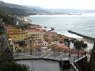
Pizzo, also called Pizzo Calabro, is a seaport and comune in the province of Vibo Valentia, situated on a steep cliff overlooking the Gulf of Saint Euphemia.
The Liro is a torrente, or stream, in the north Italian Province of Como. The drainage basin is triangular in shape; its principal source lies on Monte Marmontana near the Swiss border and flows through the Valle San Iorio. The second source lies to the northeast on the slopes of Pizzo Martello and forms the Valle del Dosso. Near Dosso del Liro the stream receives the waters of the torrente Ronzone, which flows from Monte Duria through the Val d’Inferno. The Liro enters Lake Como at Gravedona.

Pizzo Campo Tencia is a mountain in the Lepontine Alps, which lies in the canton of Ticino, Switzerland. Pizzo Campo Tencia is the highest peak located entirely inside the canton.
Pizzo di Röd is a mountain of the Lepontine Alps, overlooking Fusio in the canton of Ticino. It is located on the chain separating the Valle di Peccia from the Val Lavizzara.

The Cima della Bondasca or Pizzo del Ferro centrale is a mountain in the Bregaglia Range (Alps), located on the border between Italy and Switzerland. Its summit is the triple watershed between Valle del Ferro (Italy), Val Bondasca and Val d'Albigna (Switzerland).
Pizzo di Porcaresc is a mountain of the Lepontine Alps, located on the border between Switzerland and Italy. Its summit is the tripoint between the Valle dell'Isorno, the Valle di Campo and the Valle di Vergeletto.
Pizzo di Brünesc is a mountain of the Lepontine Alps, overlooking Cavergno, in the canton of Ticino. It lies at the southern end of the chain between the Val Bavona and Valle di Peccia.
Pizzo d'Orsalia is a mountain of the Swiss Lepontine Alps, overlooking Bosco/Gurin in the canton of Ticino. It lies on the chain that separates the Val Calnègia from the Valle di Bosco/Gurin.
The Rosso di Ribia is a mountain of the Lepontine Alps, located in the canton of Ticino, Switzerland. with a height of 2,547 metres above sea level, it is the culminating point on the range between the Valle di Campo and Valle di Vergeletto. The Rosso di Ribia lies five kilometres east of Pizzo di Porcarese, where the border with Italy runs.
The Corona di Redorta is a mountain of the Swiss Lepontine Alps, located between Lavizzara and Sonogno in the canton of Ticino. Culminating at a height of 2,804 metres above sea level, the Corona di Redorta is the second highest summit of the Valle Verzasca, after Pizzo Barone.
Pizzo delle Pecore is a mountain of the Swiss Lepontine Alps, located east of Cevio in the canton of Ticino. It lies just south of the slightly higher Cima di Broglio, on the range between the Valle Maggia and the Valle Verzasca.
The Poncione Piancascia is a mountain of the Swiss Lepontine Alps, overlooking Brione in the canton of Ticino. It lies between the Valle Maggia and the Valle Verzasca. The Poncione di Piancascia has an elevation of 2,360 metres and is the highest summit on the range south of Pizzo delle Pecore.
Pizzo di Cadrèigh is a mountain of the Swiss Lepontine Alps, located west of Olivone in the canton of Ticino. It lies south of the Scopi, between the Val di Campo and the Valle Santa Maria.
Valle Vigezzo is a valley in the Lepontine Alps in northwestern Italy on the border with Canton Ticino of Switzerland. It forms the eastern branch of the Ossola valley. It is also called the Valle dei Pittori due to the large number of painters over the centuries such as Giuseppe Mattia Borgnis, Lorenzo Peretti, Bernardino Peretti, Enrico Cavalli, Carlo Fornara, Giovanni Battista Ciolina, Gian Maria Rastellini, Maurizio Borgnis, Lorenzo Peretti Junior. It is remembered for its "spazzacamini" or chimney-sweepers who brought their trade around Europe. It is connected with the Eau de Cologne, invented over 300 years ago by Giovanni Maria Farina using, among other ingredients flowers and oils from plants from Vigezzo. Another man from Vigezzo, Giovan Maria Salati is credited to be the first recorded person swimming across the English Channel over 200 years ago, after having been taken prisoner by the British after Waterloo.

Pizzo Stella or Pizzo Sterla is a mountain of Lombardy, Italy, located north of Chiavenna. On its northern side it overlooks the Valle di Lei and the lake Lago di Lei.

Val Grande National Park is a protected area located in Piedmont, in the north of Italy, at the border with Switzerland. It is most notable for landscapes of the High Alps.

The border between the modern states of Switzerland and Italy extends for 744 kilometres (462 mi), from the French-Swiss-Italian tripoint at Mont Dolent in the west to the Austrian-Swiss-Italian tripoint near Piz Lad in the east. Much of the border runs across the High Alps, rising above 4,600 metres (15,100 ft) as it passes east of Dufourspitze, but it also descends to the lowest point in Switzerland as it passes Lago Maggiore at below 200 metres (660 ft).
The Passo di Predèlp (2,449 m, is a high mountain pass of the Lepontine Alps, located between the Valle Santa Maria and the Leventina, in Ticino.

The Altemberg is a mountain in the Pennine Alps of north-western Italy; with an elevation of 2,395 m (7,858 ft) is the highest peak of the Alpi Cusiane.
