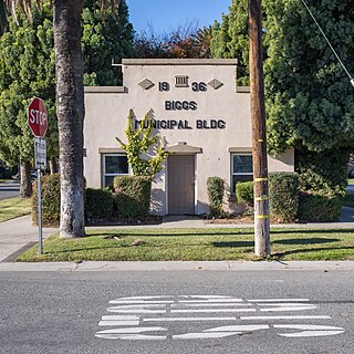
Biggs is a city in Butte County, California, United States. The population was 1,707 at the 2010 census, down from 1,793 at the 2000 census. The 2018 population estimate is 1,724.

The Effelsberg 100-m Radio Telescope is a radio telescope in the Ahr Hills in Bad Münstereifel, Germany. For 29 years the Effelsberg Radio Telescope was the largest fully steerable radio telescope on Earth, surpassing the Lovell Telescope in the UK. In 2000, it was surpassed by the Green Bank Observatory's Robert C. Byrd Green Bank Telescope in Green Bank, US, which has a slightly larger elliptical 100 by 110-metre aperture.

St George's Bridge was a bridge over the River Severn in Shrewsbury, England; so named as it was close to the medieval St George's Hospital. It connected Frankwell, an old suburb of the town, to the town centre via Mardol. The gate on the town side was called Mardol Gate and is located where the Mardol Quay Gardens are. The gate on the other side was called Welsh Gate or St George's Gate. The bridge, sometimes now known as the Old Welsh Bridge, was demolished in 1795 and was replaced with the Welsh Bridge.

Bad Münstereifel is a historical spa town in the district of Euskirchen, Germany, with about 17,000 inhabitants, situated in the far southwest of the German state of North Rhine-Westphalia. The little town is one of only a few historical towns in the southwest of North Rhine-Westphalia, and because of this is often overcrowded by tourists throughout spring and summer.
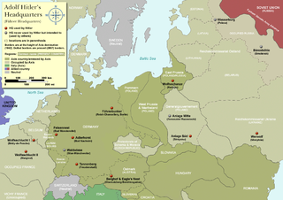
The Felsennest was the codename for one of several Führer Headquarters used by Adolf Hitler during the course of World War II.

Saint George is an administrative parish of Saint Vincent and the Grenadines, situated in the most southerly portion of the island of Saint Vincent. With an area of 52 km2 it is the country's third largest parish by total area. According to the 2000 census it has a population of approximately 52,400 making it the most populous parish in Saint Vincent and the Grenadines and by extent, the most densely populated as well. Its population accounts for 44% of that of the country and its area, only 13%.
Uthayendram is a town in Tirupathur district in the Indian state of Tamil Nadu.

Liffré is a commune in the Ille-et-Vilaine department in Brittany in northwestern France. It is in the center of the region.

Galena Township is one of twenty-one townships in LaPorte County, Indiana. As of the 2020 census, its population was 1,980 and it contained 979 housing units.
Reno is an unincorporated community in Clay Township, Hendricks County, Indiana.
Hann Bel-Air is a commune d'arrondissement of the city of Dakar, Senegal.

Valle de Valdelaguna is a town in the province of Burgos, Autonomous Community of Castilla y León (Spain), region of the Complaint, the judicial district of Salas de los Infantes. Its capital is the town of Huerta de Abajo.
Kongaye is a town in the Piéla Department of Gnagna Province in eastern Burkina Faso. The town has a population of 2586.
Noali is a town in the Piéla Department of Gnagna Province in eastern Burkina Faso. The town has a population of 1038.
Tiabdou is a town in the Piéla Department of Gnagna Province in eastern Burkina Faso. The village has a population of 1009.

Church of the Magdalene is a church in Lisbon, Portugal. Its portal is classified as a National Monument.
Reading is an extinct town in Pike County, in the U.S. state of Missouri. The GNIS classifies it as a populated place.
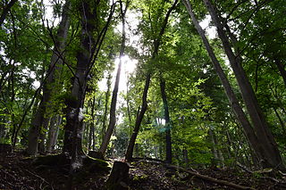
Münstereifel Forest is a densely wooded region in the northern part of the Eifel mountains in North Rhine-Westphalia, Germany. In the south, it borders the state of Rhineland-Palatinate. It has an area of 237 km² and an elevation between 200 and 500 m above sea level (NHN).
Arloff is a village in the borough of Bad Münstereifel in the district of Euskirchen in the German state of North Rhine-Westphalia.

Houverath is a village in the town of Bad Münstereifel in the district of Euskirchen, in the German state of North Rhine-Westphalia.

