Related Research Articles
Soil retrogression and degradation are two regressive evolution processes associated with the loss of equilibrium of a stable soil. Retrogression is primarily due to soil erosion and corresponds to a phenomenon where succession reverts the land to its natural physical state. Degradation is an evolution, different from natural evolution, related to the local climate and vegetation. It is due to the replacement of primary plant communities by the secondary communities. This replacement modifies the humus composition and amount, and affects the formation of the soil. It is directly related to human activity. Soil degradation may also be viewed as any change or ecological disturbance to the soil perceived to be deleterious or undesirable.
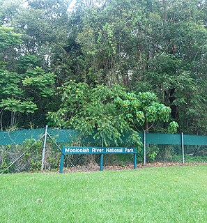
The Mooloolah River National Park is a nationally protected area located on the Sunshine Coast, Queensland. It covers an area of 830.9 hectares and is bordered by the Mooloolah River to the east, Claymore and Dixon Roads to the west, and the Lower Mooloolah River Environmental Reserve to the south. It is bisected by the Sunshine Motorway with the northern, 161.93 hectare component of the Park being a later addition. The Park was initially vacant crown land prior to national park designation in 1960. Surrounding land uses include livestock grazing, urban development and the campus of the University of the Sunshine Coast. It is the second largest mainland park on the coastal lowlands in South East Queensland after Noosa National Park and represents an example of low-lying coastal floodplain distinctive of the region.

Sclerophyll is a type of vegetation that has hard leaves, short internodes and leaf orientation parallel or oblique to direct sunlight that are adapted to long periods of dryness and heat that some types of vegetation present. The word comes from the Greek sklēros (hard) and phyllon (leaf). The term was coined by A.F.W. Schimper in 1898, originally as a synonym of xeromorph, but later was changed.

Grasslands are areas where the vegetation is dominated by grasses (Poaceae). However, sedge (Cyperaceae) and rush (Juncaceae) can also be found along with variable proportions of legumes, like clover, and other herbs. Grasslands occur naturally on all continents except Antarctica and are found in most ecoregions of the Earth. Furthermore, grasslands are one of the largest biomes on earth and dominate the landscape worldwide. There are different types of grasslands: natural grasslands, semi-natural grasslands, and agricultural grasslands. They cover 31–43% of the Earth's land area.

A savanna or savannah is a mixed woodland-grassland ecosystem characterised by the trees being sufficiently widely spaced so that the canopy does not close. The open canopy allows sufficient light to reach the ground to support an unbroken herbaceous layer consisting primarily of grasses.

Pasture is land used for grazing. Pasture lands in the narrow sense are enclosed tracts of farmland, grazed by domesticated livestock, such as horses, cattle, sheep, or swine. The vegetation of tended pasture, forage, consists mainly of grasses, with an interspersion of legumes and other forbs. Pasture is typically grazed throughout the summer, in contrast to meadow which is ungrazed or used for grazing only after being mown to make hay for animal fodder. Pasture in a wider sense additionally includes rangelands, other unenclosed pastoral systems, and land types used by wild animals for grazing or browsing.

In scientific ecology, climax community or climatic climax community is a historic term for a community of plants, animals, and fungi which, through the process of ecological succession in the development of vegetation in an area over time, have reached a steady state. This equilibrium was thought to occur because the climax community is composed of species best adapted to average conditions in that area. The term is sometimes also applied in soil development. Nevertheless, it has been found that a "steady state" is more apparent than real, particularly across long timescales. Notwithstanding, it remains a useful concept.

Ecological succession is the process of change in the species structure of an ecological community over time. The time scale can be decades or more or less.

A heath is a shrubland habitat found mainly on free-draining infertile, acidic soils and characterised by open, low-growing woody vegetation. Moorland is generally related to high-ground heaths with—especially in Great Britain—a cooler and damper climate.

Moorland or moor is a type of habitat found in upland areas in temperate grasslands, savannas, and shrublands and montane grasslands and shrublands biomes, characterised by low-growing vegetation on acidic soils. Moorland, nowadays, generally means uncultivated hill land, but also includes low-lying wetlands. It is closely related to heath, although experts disagree on what precisely distinguishes these types of vegetation. Generally, moor refers to highland and high rainfall zones, whereas heath refers to lowland zones which are more likely to be the result of human activity. Moorland habitats mostly occur in tropical Africa, northern and western Europe, and neotropical South America. Most of the world's moorlands are diverse ecosystems. In the extensive moorlands of the tropics, biodiversity can be extremely high. Moorland also bears a relationship to tundra, appearing as the tundra and the natural tree zone. The boundary between tundra and moorland constantly shifts with climatic change.

In agriculture, grazing is a method of animal husbandry whereby domestic livestock are allowed outdoors to roam around and consume wild vegetations in order to convert the otherwise indigestible cellulose within grass and other forages into meat, milk, wool and other animal products, often on land unsuitable for arable farming.

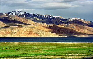
Páramo can refer to a variety of alpine tundra ecosystems located in the Andes Mountain Range, South America. Some ecologists describe the páramo broadly as "all high, tropical, montane vegetation above the continuous timberline". A narrower term classifies the páramo according to its regional placement in the northern Andes of South America and adjacent southern Central America. The páramo is the ecosystem of the regions above the continuous forest line, yet below the permanent snowline. It is a "Neotropical high mountain biome with a vegetation composed mainly of giant rosette plants, shrubs and grasses". According to scientists, páramos may be "evolutionary hot spots" and among the fastest evolving regions on Earth.
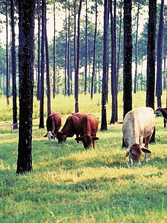
Silvopasture is the practice of integrating trees, forage, and the grazing of domesticated animals in a mutually beneficial way. It utilizes the principles of managed grazing, and it is one of several distinct forms of agroforestry.
Charles Henry Gimingham was a British botanist at the University of Aberdeen, patron of the Institute of Ecology and Environmental Management, former president of the British Ecological Society, and one of the leading researchers of heathlands and heathers.

Conservation grazing or targeted grazing is the use of semi-feral or domesticated grazing livestock to maintain and increase the biodiversity of natural or semi-natural grasslands, heathlands, wood pasture, wetlands and many other habitats. Conservation grazing is generally less intensive than practices such as prescribed burning, but still needs to be managed to ensure that overgrazing does not occur. The practice has proven to be beneficial in moderation in restoring and maintaining grassland and heathland ecosystems. The optimal level of grazing will depend on the goal of conservation, and different levels of grazing, alongside other conservation practices, can be used to induce the desired results.

Barren vegetation describes an area of land where plant growth may be sparse, stunted, and/or contain limited biodiversity. Environmental conditions such as toxic or infertile soil, high winds, coastal salt-spray, and climatic conditions are often key factors in poor plant growth and development. Barren vegetation can be categorized depending on the climate, geology, and geographic location of a specific area.
Lowland heath is a Biodiversity Action Plan habitat as it is a type of ancient wild landscape. Natural England's Environmental Stewardship scheme describes lowland heath as containing dry heath, wet heath and valley mire communities, usually below 250 metres (820 ft) in altitude, on acidic soils and shallow peat, typically comprising heathers, gorses, fine grasses, wild flowers and lichens in a complex mosaic. Heathers and other dwarf shrubs usually account for at least 25% of the ground cover. By contrast, upland heath, which is above 300 metres (980 ft) in altitude, is called moorland, Dartmoor being an example.
The Alpine-steppe is a high altitude natural alpine grassland, which is a part of the Montane grasslands and shrublands biome.
Chalk heath is a rare habitat, in the temperate grasslands, savannas, and shrublands biome, formed of a paradoxical mixture of shallow-rooted calcifuge ("calcium-hating") and deeper-rooted calcicole ("calcium-loving") plants, growing on a thin layer of acidic soil over an alkaline substrate. Chalk heath is intermediate between two much more widespread habitats, chalk grassland and heathland.
Wales has a surface area of 20,779 km2 or 2,077,900 ha. It has a border with England to the east, and is bounded by the Irish Sea to the north and west, and by the Bristol Channel to the south. It has an oceanic temperate climate which is markedly influenced by the North Atlantic Current carrying warm water from tropical latitudes. As a result, it has a much milder climate than most places in the world at similar latitudes. Altitudes range from sea-level to 1085 m on the Snowdon Massif.
References
- Palmer, Andy; Nigel Yates (2005). Advanced Geography. Philip Allan Updates. pp. 380. ISBN 1-84489-205-0.
- Warn, Sue (2000). "Heathland and Moorland Ecosystems". ISSN 1351-5136.
{{cite journal}}: Cite journal requires|journal=(help)
| | This article about environmental habitats is a stub. You can help Wikipedia by expanding it. |