
Las Palmas, officially Las Palmas de Gran Canaria, is a Spanish city and capital of Gran Canaria, in the Canary Islands, on the Atlantic Ocean.

Playa del Rey is a seaside community in the Santa Monica Bay and the Westside region of Los Angeles, California. It has a ZIP code of 90293 and area codes of 310 and 424. As of 2018, the community had a population of 16,230 people.

Puerto Escondido is a small port and tourist center in the municipality of San Pedro Mixtepec Distrito 22 in the Mexican state of Oaxaca. Prior to the 1930s, there was no town. The bay had been used as a port intermittently to ship coffee, but there was no permanent settlement due to the lack of potable water. The name "Puerto Escondido" had roots in the legend of a woman who escaped her captors and hid here. The Nahuatl word for this area was Zicatela, meaning “place of large thorns". Today, it refers to the area's most famous beach.

Margarita Island is the largest island in the Venezuelan state of Nueva Esparta, situated off the northeastern coast of the country, in the Caribbean Sea. The capital city of Nueva Esparta, La Asunción, is located on the island.

El Médano is a town in the municipality of Granadilla de Abona, on the island of Tenerife, one of the Canary Islands. It is located about 11 kilometers from the town of Granadilla, reaching an average altitude of 75 meters above sea level.
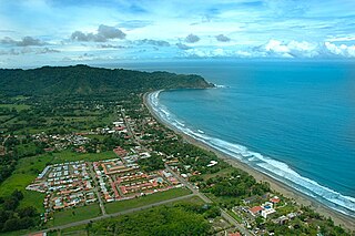
Jacó is a district of the Garabito canton, in the Puntarenas province of Costa Rica. Jacó has a black sand beach that is 4 km (2.5 mi) long and is popular among surfers.
Castillo de Salas was a Spanish bulk carrier that was launched in Ferrol on 20 December 1979 and completed in August 1980. It measured over 50,000 gross tons, and had a deadweight of over 100,000 tons, measured approximately 250 metres (820 ft) in length, 40 metres (130 ft) across the beam, and 14.5 metres (48 ft) in draft. It required a crew complement of 32.

Cala Arenas is a beach situated near the city of Algeciras in Spain, within the El Estrecho Natural Park. It is located at the southern end of the Bay of Gibraltar and faces the Strait of Gibraltar. It measures about 400 metres (1,300 ft) long by about 30 metres (98 ft) deep. The beach is somewhat difficult to access, but can be reached via coastal paths from Punta Carnero and Punta del Fraile. It consists of a series of three small coves of similar appearance, with beaches of rocks and small stones. Both the terrestrial and marine environment of the area lies within the natural park. Its surroundings are largely undisturbed by human activity; the nearest settlement is the coastal community of Getares, a small outlying development of the city of Algeciras located about 1 km to the north. The beach is framed by cliffs and the Isla de las Palomas lies a short distance offshore.

Playa del Barranco is a beach in the municipality of Algeciras, southeastern Spain. It overlooks the Bay of Algeciras. It is approximately 500 metres in length. To the north is the Playa de El Rinconcillo.

Playa de El Chinarral is a beach in the municipality of Algeciras, southeastern Spain. It overlooks the Bay of Algeciras and the tip of the rock of Gibraltar. It is approximately 250 metres in length and 40 metres wide on average. It is located between Punta de San Garcia and El Rodeo, south of the city.

Playa de Los Ladrillos is a beach in the municipality of Algeciras, southeastern Spain. It overlooks the Bay of Algeciras, next to Playa del Barranco. It is about 200 metres in length.
Playa del Chorrillo is a beach of Ceuta, a Spanish city bordering northern Morocco. Like the Playa de la Ribera, it lies to the south of the isthmus. It has a length of about 1200 metres and average width of 30 metres, with black sand.

Playa de la Ribera is a beach of Ceuta, a Spanish city bordering northern Morocco. Like the Playa del Chorillo, it lies to the south of the isthmus but on the part where it joins the mainland. It is about 405 metres long, with an average width of 40 metres. It is very busy during the summer months.

Playa Benítez is a beach of Ceuta, a Spanish city bordering northern Morocco. The beach is about 900 metres (3,000 ft) in length with an average width of about 200 metres (660 ft). It forms part of the Punta Blanca. The beach is popular with sports enthusiasts.

Playa El Tarajal is a beach of Ceuta, bordering northern Morocco. The beach is about 250 metres in length with an average width of about 15 metres.

Playa de La Atunara is a beach in the municipality of La Línea de la Concepción, in the Province of Cádiz, Andalusia, Spain. It has a length of about 1.5 kilometres (0.93 mi) and average width of about 90 metres (300 ft). It is a busy beach and bordered on the south by the Playa de Levante and north by the Playa de Torrenueva. In its vicinity are the remains of the Tunara battery. It has a seafront promenade of restaurants, known for their pescaitos and clams. Among the highlights are the traditions of the Virgin of Carmen exiting the port of La Atunara through the streets in a parade. It has all the basic services required of an urban beach, daily waste collection season, toilets, showers and disabled access and presence of police and local rescue equipment.
Playa de La Hacienda is a beach in the municipality of La Línea de la Concepción, in the Province of Cádiz, Andalusia, Spain. It has a length of about 4.3 kilometres (2.7 mi) and average width of about 90 metres (300 ft). It is a busy beach north of the city and bordered to the south with the Playa de Torrenueva and to the north with the Playa de La Alcaidesa.

Somorrostro Beach is one of the beaches in Barcelona, Catalonia, Spain. It is located between Hospital del Mar and Marina Street, in the far east area of the Barceloneta neighborhood, in the Ciutat Vella district. It is 522 metres (1,713 ft) long and 89 metres (292 ft) wide. The Somorrostro name was forgotten and the beach became one of the most popular in the city. It was not until 2010, Somorrostro beach got its original name back.

The Copa América of Beach Soccer is a biennial international beach soccer tournament contested between the senior men's national teams of the 10 members of CONMEBOL. It is beach soccer's version of the better known Copa América in its parent sport, association football.

