
A defensive wall is a fortification usually used to protect a city, town or other settlement from potential aggressors. The walls can range from simple palisades or earthworks to extensive military fortifications such as curtain walls with towers, bastions and gates for access to the city. From ancient to modern times, they were used to enclose settlements. Generally, these are referred to as city walls or town walls, although there were also walls, such as the Great Wall of China, Walls of Benin, Hadrian's Wall, Anastasian Wall, and the Atlantic Wall, which extended far beyond the borders of a city and were used to enclose regions or mark territorial boundaries. In mountainous terrain, defensive walls such as letzis were used in combination with castles to seal valleys from potential attack. Beyond their defensive utility, many walls also had important symbolic functions – representing the status and independence of the communities they embraced.

A fortification is a military construction designed for the defense of territories in warfare, and is used to establish rule in a region during peacetime. The term is derived from Latin fortis ("strong") and facere.

The Floriana Lines are a line of fortifications in Floriana, Malta, which surround the fortifications of Valletta and form the capital city's outer defences. Construction of the lines began in 1636 and they were named after the military engineer who designed them, Pietro Paolo Floriani. The Floriana Lines were modified throughout the course of the 17th and 18th centuries, and they saw use during the French blockade of 1798–1800. Today, the fortifications are still largely intact but rather dilapidated and in need of restoration.

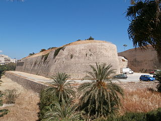
The Fortezza is the citadel of the city of Rethymno in Crete, Greece. It was built by the Venetians in the 16th century, and was captured by the Ottomans in 1646. By the early 20th century, many houses were built within the citadel. These were demolished after World War II, leaving only a few historic buildings within the Fortezza. Today, the citadel is in good condition and is open to the public.

The fortifications of Copenhagen underwent a comprehensive modernization and expansion in the 17th century. The project was commenced and was largely the masterplan of Christian IV in the early 17th century but was continued and completed by his successors. The new fortifications relied on the existing, medieval fortifications of the city but the fortified area was extended and a defensive ring around the city completed particularly with new edifices facing the sea. The ring fortification consisted of four bastioned ramparts and an annexed citadel as well as various outworks.

The Walls of Nicosia, also known as the Venetian Walls, are a series of defensive walls which surround Nicosia, the capital city of Cyprus. The first city walls were built in the Middle Ages, but they were completely rebuilt in the mid-16th century by the Republic of Venice during their war with the Ottoman Empire. The walls are still largely intact, and are among the best preserved Renaissance fortifications in the Eastern Mediterranean. They are a major tourist attraction.

Flat Bastion is a bastion which projects southward from the Charles V Wall in the British Overseas Territory of Gibraltar. Once known as the St. Jago's Bastion or the Baluarte de Santiago in Spanish, the fortification was built by the Spanish in the mid 16th century and formed part of the southern defences of the city of Gibraltar, together with Charles V Wall, Southport Gates, Southport Ditch, and South Bastion. In 1859, six guns, four 12-pounders and two 12-pound carronades, were installed on the bastion, and four years later, five 32-pounders were mounted on the fortification.

The Southport Gates are three city gates in the British Overseas Territory of Gibraltar. They are located in the Charles V Wall, one of the 16th century fortifications of Gibraltar. The gates are clustered together, with the South Bastion to the west, and the Trafalgar Cemetery to the east. The first and second Southport Gates were constructed at present day Trafalgar Road in 1552 and 1883, respectively. The third gate, Referendum Gate, is the widest of the three and was constructed in 1967 at Main Street, immediately west of the first two gates. The Southport Gates are listed with the Gibraltar Heritage Trust.

The Charles V Wall is a 16th-century defensive curtain wall that forms part of the fortifications of the British Overseas Territory of Gibraltar. Originally called Muralla de San Benito, it was built in 1540 and strengthened in 1552 by Holy Roman Emperor Charles V. The wall remains largely intact and extends from South Bastion, which was once at the water's edge in the harbour, to the top ridge of the Rock of Gibraltar.

The South Bastion was part of the fortifications of Gibraltar, protecting the western base of the Charles V Wall. It was originally built by Spanish military engineers, later improved by the British. The South Bastion stands at the south end of the Line Wall Curtain which defends the town from attack from the Bay of Gibraltar. Another curtain wall runs east from the bastion to the base of a precipice. This wall is pierced by the Southport Gates, guarded by the South Bastion and the Flat Bastion on either side.
Giovan Giacomo Paleari Fratino (1520–1586), known as El Fratin or Il Fratino, was a military engineer who served the Holy Roman Emperor and King of Spain Emperor Charles V, and then his son Philip II of Spain. He is known for having designed the first Martello tower as well as many other fortifications.

The North Bastion, formerly the Baluarte San Pablo was part of the fortifications of Gibraltar, in the north of the peninsula, protecting the town against attack from the mainland of Spain. The bastion was based on the older Giralda tower, built in 1309. The bastion, with a mole that extended into the Bay of Gibraltar to the west and a curtain wall stretching to the Rock of Gibraltar on its east, was a key element in the defenses of the peninsula. After the British took Gibraltar in 1704 they further strengthened these fortifications, flooding the land in front and turning the curtain wall into the Grand Battery.

Zoca Flank Battery is an artillery battery on the west side of the British Overseas Territory of Gibraltar.

The Gibraltar peninsula, located at the far southern end of Iberia, has great strategic importance as a result of its position by the Strait of Gibraltar where the Mediterranean Sea meets the Atlantic Ocean. It has repeatedly been contested between European and North African powers and has endured fourteen sieges since it was first settled in the 11th century. The peninsula's occupants – Moors, Spanish, and British – have built successive layers of fortifications and defences including walls, bastions, casemates, gun batteries, magazines, tunnels and galleries. At their peak in 1865, the fortifications housed around 681 guns mounted in 110 batteries and positions, guarding all land and sea approaches to Gibraltar. The fortifications continued to be in military use until as late as the 1970s and by the time tunnelling ceased in the late 1960s, over 34 miles (55 km) of galleries had been dug in an area of only 2.6 square miles (6.7 km2).

The fortifications of Valletta are a series of defensive walls and other fortifications which surround Valletta, the capital city of Malta. The first fortification to be built was Fort Saint Elmo in 1552, but the fortifications of the city proper began to be built in 1566 when it was founded by Grand Master Jean de Valette. Modifications were made throughout the following centuries, with the last major addition being Fort Lascaris which was completed in 1856. Most of the fortifications remain largely intact today.

The fortifications of Mdina are a series of defensive walls which surround Mdina, the former capital city of Malta from antiquity to the medieval period. The city was founded as Maleth by the Phoenicians in around the 8th century BC, and it later became part of the Roman Empire under the name Melite. The ancient city was surrounded by walls, but very few remains of these have survived.
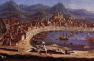
The Real Cittadella was a fort in Messina, Sicily. The Cittadella was built between 1680 and 1686 by the Spanish Empire, and it was considered to be one of the most important fortifications in the Mediterranean. Most of the fort was demolished in the 20th century, but some parts can still be seen.
The fortifications of Heraklion are a series of defensive walls and other fortifications which surround the city of Heraklion in Crete, Greece. The first city walls were built in the Middle Ages, but they were completely rebuilt by the Republic of Venice. The fortifications managed to withstand the second longest siege in history for 21 years, before the city fell to the Ottomans in 1669.


