
The Alhucemas Islands is a group of islands and one of the Spanish plazas de soberanía just off the Moroccan coast in the Alboran Sea.

Tohatchi is a census-designated place (CDP) in McKinley County, New Mexico, United States. The population was 1,037 at the 2000 census. Tohatchi is located on the Navajo Nation.

CILV-FM is a radio station licensed to Ottawa, Ontario. Owned by Stingray Digital, it broadcasts an alternative rock format. Its studios are located on Antares Drive in Nepean, while its transmitter is located in Greely, Ontario.
The Scuppernong River is a blackwater river that flows through Tyrrell County and Washington County, North Carolina, into the Albemarle Sound. It is a tributary of the Pasquotank River Basin. The river shares its name with the Scuppernong grapes native to the area.

Mama Khel is a town and union council in Lakki Marwat District of Khyber-Pakhtunkhwa. It is located at 32°51'1N 70°46'51E and has an altitude of 280 metres.
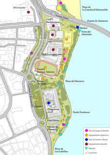
Paseo Cornisa is a park in Algeciras, Spain. It was inaugurated in May 2007. It stretches for just over a kilometre between Punta del Cementerio and Punta del Almirante in the north of the city near the old cemetery and parallel to the Playa del Barranco and Playa de El Rinconcillo. The park has an area of over 20,000 square metres (220,000 sq ft). Within the park is the Torre del Almirante or Admiral's Tower which dates from the 14th century.

Playa del Barranco is a beach in the municipality of Algeciras, southeastern Spain. It overlooks the Bay of Algeciras. It is approximately 500 metres in length. To the north is the Playa de El Rinconcillo.

Playa de El Chinarral is a beach in the municipality of Algeciras, southeastern Spain. It overlooks the Bay of Algeciras and the tip of the rock of Gibraltar. It is approximately 250 metres in length and 40 metres wide on average. It is located between Punta de San Garcia and El Rodeo, south of the city.

Playa de Los Ladrillos is a beach in the municipality of Algeciras, southeastern Spain. It overlooks the Bay of Algeciras, next to Playa del Barranco. It is about 200 metres in length.

Iglesia de San Francisco is a church in the Spanish city of Ceuta, bordering northern Morocco. It stands at the side of the Plaza de los Reyes, and is a distinctive Baroque twin-towered yellow building. It was built in the early eighteenth century in honour of the Holy Cross and is noted for its Baroque altarpieces and images of the Virgin and Christ.
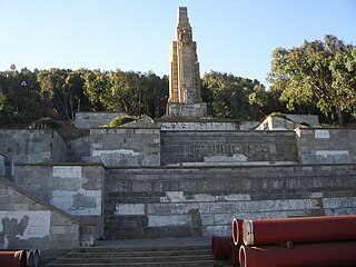
Monumento del Llano Amarillo is a monument in the Spanish territory of Ceuta, in the North of Africa, at the bottom of Mount Hacho. The fifteen metre monument was moved here from Morocco in 1962 and it is one of the few sculptures left that record Spain's period of Nationalism following the Spanish Civil War.
Playa Calamocarro is a beach of Ceuta, a Spanish city bordering northern Morocco. The beach is about 650 metres in length with an average width of about 15 metres. The area forms part of a protected ZEPA zone.

Playa El Desnarigado is a small beach of Ceuta, a Spanish city bordering northern Morocco. The beach is about 80 metres in length with an average width of about six metres.

Playa Benítez is a beach of Ceuta, a Spanish city bordering northern Morocco. The beach is about 900 metres (3,000 ft) in length with an average width of about 200 metres (660 ft). It forms part of the Punta Blanca. The beach is popular with sports enthusiasts.
Playa El Tarajal is a beach of Ceuta, bordering northern Morocco. The beach is about 250 metres in length with an average width of about 15 metres.
Playar Miramar is a beach of Ceuta, a Spanish city bordering northern Morocco. The beach is about 275 metres in length with an average width of about 18 metres.

Playa del Sarchal is a beach of Ceuta, a Spanish city bordering northern Morocco. The beach has a cliff and is about 350 metres in length with an average width of about 10 metres.

Playa San Amaro is a beach of Ceuta, a Spanish city bordering northern Morocco. The sandy beach is about 280 metres in length with an average width of about 6 metres and will be well occupied in the tourist season.

Playa de La Atunara is a beach in the municipality of La Línea de la Concepción, in the Province of Cádiz, Andalusia, Spain. It has a length of about 1.5 kilometres (0.93 mi) and average width of about 90 metres (300 ft). It is a busy beach and bordered on the south by the Playa de Levante and north by the Playa de Torrenueva. In its vicinity are the remains of the Tunara battery. It has a seafront promenade of restaurants, known for their pescaitos and clams. Among the highlights are the traditions of the Virgin of Carmen exiting the port of La Atunara through the streets in a parade. It has all the basic services required of an urban beach, daily waste collection season, toilets, showers and disabled access and presence of police and local rescue equipment.


