Baddesley Clinton is a moated manor house, about 8 miles (13 km) north-west of the town of Warwick, in the village of Baddesley Clinton, Warwickshire, England. The house probably originated in the 13th century, when large areas of the Forest of Arden were cleared for farmland. The site is a Scheduled Ancient Monument and the house is a Grade I listed building. The house, park and gardens are owned by the National Trust and open to the public; they lie in a civil parish of the same name.

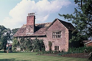
Helmingham Hall is a moated manor house in Helmingham, Suffolk, England. It was begun by John Tollemache in 1480 and has been owned by the Tollemache family ever since. The house is built around a courtyard in typical late medieval/Tudor style. The house is listed Grade I on the National Heritage List for England, and its park and formal gardens are also Grade I listed on the Register of Historic Parks and Gardens.

Gisleham is a village and civil parish in the English county of Suffolk. It is on the edge of Lowestoft, around 4.5 miles (7.2 km) south-west of the town centre. The parish is in the East Suffolk district, situated between Carlton Colville and Kessingland.

Eshott Hall is a privately owned mansion house, a Grade II listed building, situated at Eshott, near Felton, Northumberland, England.

Clayton Hall is a 15th-century manor house on Ashton New Road in Clayton, Manchester, England, hidden behind trees in a small park. The hall is a Grade II* listed building, the mound on which it is built is a scheduled ancient monument, and a rare example of a medieval moated site. The hall is surrounded by a moat, making an island 66 m by 74 m. Alterations were made to the hall in the 16th and 17th centuries, and it was enlarged in the 18th century.
Chorley Old Hall is a moated manor house on the B5359 road to the southwest of Alderley Edge, Cheshire, England. The house is recorded in the National Heritage List for England as a designated Grade I listed building, and the moated site is a scheduled monument. It is the oldest inhabited country house in Cheshire and consists of two ranges, one medieval and the other Elizabethan.

Parham Old Hall, also known as Moat Hall, is a moated site and historic medieval mansion close to the village of Parham, in Suffolk, England. Closely associated with the Barons Willoughby of Parham, it is a Grade II listed building on the National Heritage List for England and includes the remains of a formal garden. The site is a scheduled monument with remains of a 15th- and 16th-century hall on its central island. A gateway that featured heraldic shields of the Willoughbys was dismantled and shipped to America in 1926. There is in the locality another unconnected building known as Parham New Hall.

Hoo is a village and civil parish in the East Suffolk district of the English county of Suffolk. It is located 3 miles (4.8 km) north-west of the town of Wickham Market and 3 miles (4.8 km) south-west of Framlingham. The parish lies to the south of the River Deben - neighbouring villages include Kettleburgh, Charsfield and Letheringham. The parish council is combined with Cretingham and Monewden, with Hoo itself having one of the smallest populations in Suffolk with 86 residents recorded at the 2001 census. At the 2011 Census, the parish was recorded in combination with Letheringham giving a total population of 160.

Morleys Hall, a moated hall converted to two houses, is situated at grid reference SJ 689 992 on Morleys Lane, on the edge of Astley Moss in Astley in the historic county of Lancashire and the ceremonial county of Greater Manchester, England. It was largely rebuilt in the 19th century on the site of a medieval timber house. The hall is a Grade II* listed building and the moat a scheduled ancient monument. Morleys is a private residence.

Holford Hall is a country house west of the village of Plumley, Cheshire, England. It consists of a fragment of a much larger timber-framed house, built in 1601 for Mary Cholmondeley on a moated site. Part of the building was demolished in the 1880s. The house is timber-framed with rendered infill. It has a stone-slate roof. The entrance front has two bays with gables and Ionic pilasters. The architectural historian Nikolaus Pevsner describes this front as being "highly decorated". The house is recorded in the National Heritage List for England as a designated Grade II* listed building. The stone bridge leading to the house across the moat is listed at Grade II, and the moated site on which the house stands is a scheduled monument.

Hulme Hall is a house on a moated site in the parish of Allostock, Cheshire, England. It originated in the 15th century, with additions and alterations in the 17th and 19th centuries. It is now a farmhouse. The house is constructed in brown brick, and has a roof of stone-slate and Welsh slate. It is in two storeys with an attic, and has an asymmetrical plan. The northeast front is the entrance front, and has three gabled bays. The garden front is on the northwest; it has five bays, two of which are stepped back in two stages. Most of the windows are two or three-light casements. The house is recorded in the National Heritage List for England as a designated Grade II* listed building. The bridge over the moat leading to the house is also listed at Grade II*. The moated site on which the house stands is a scheduled monument. It had been the home of the Grosvenor and Shakerley families, both of whom were prominent in Cheshire.

Lower Huxley Hall is a moated manor house in Cheshire, England, located about 6.5 miles (10 km) southeast of Chester. It lies roughly halfway between the villages of Huxley and Hargrave, It dates from the late 15th century, with major additions and alterations in the 17th century. A small addition was made to the rear in the 19th century. It was originally a courtyard house, but only two wings remain. The house is designated by English Heritage as a Grade II* listed building.
Lymm Hall is a moated country house in the village suburb of Lymm in Warrington, Cheshire, England. It is recorded in the National Heritage List for England as a designated Grade II* listed building.

Shotwick Hall is a former manor house in the village of Shotwick, Cheshire, England. It replaced an earlier manor house that stood on a moated site some 150 metres to the west. The hall and four associated structures are listed buildings, and the moated site is a Scheduled Monument.

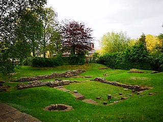
Mettingham Castle was a fortified manor house in the parish of Mettingham in the north of the English county of Suffolk.

Caludon Castle is a Scheduled Ancient Monument and Grade I listed building in Coventry, in the West Midlands of England. A second moated site 190 metres (620 ft) to the south is a Scheduled Ancient Monument in its own right. The castle is now a ruin, and all that remains is a large fragment of sandstone wall. What remains of the estate is now an urban park, owned and run by Coventry City Council, but much of it was sold and developed into housing estates in the early 20th century.
New Hall moated site is a scheduled monument in Tyldesley, Greater Manchester, England. It includes a moat and an island platform on which a modern house has been built. The island was the site of a medieval building. The moat measures between 20 and 30 metres across and is widest at the south west corner where the water soaks away to join a stream. The moat was revetted on the south side but the stonework is destroyed and is bridged on the same side by a modern stone bridge which replaced a timber structure. The rectangular island, measuring 60 metres by 40 metres, encloses an area of 0.25 hectares and is 0.4 metres above the surrounding land. Archaeological evidence of the medieval buildings will be present on the island and the moat will retain other environmental evidence. A ruined post-medieval farmhouse occupied a third of the island in 1983. The present modern buildings are excluded from the scheduling, although the ground beneath them is part of the schedule.

St Margaret South Elmham is a village and civil parish in the north of the English county of Suffolk. It is 4 miles (6.4 km) south-west of the market town of Bungay in the East Suffolk district. It is one of the parishes surrounding Bungay which are known as The Saints.
This is a list of scheduled monuments in the English county of Lancashire.