
Chaiya railway station is a first class and main railway station in northern Surat Thani Province, Thailand. It on the State Railway of Thailand (SRT) Southern railway line at km597.751 in Talad Chaiya Town, Chaiya District. It has two tracks in its rail yard, two platforms and has no siding for freight trains.
Hopârta is a commune located in Alba County, Romania. It has a population of 1372 (2002). It is composed of five villages: Hopârta, Silivaș (Mikószilvás), Șpălnaca (Ispánlaka), Turdaș (Oláhtordos) and Vama Seacă (Szárazvámtanya).

Opalenica is a village in the administrative district of Gmina Brodnica, within Brodnica County, Kuyavian-Pomeranian Voivodeship, in north-central Poland.

Jazy is a village in the administrative district of Gmina Włocławek, within Włocławek County, Kuyavian-Pomeranian Voivodeship, in north-central Poland. It lies approximately 20 kilometres (12 mi) east of Włocławek and 69 km (43 mi) south-east of Toruń.
Lamkowizna is a village in the administrative district of Gmina Wąpielsk, within Rypin County, Kuyavian-Pomeranian Voivodeship, in north-central Poland.
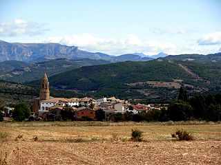
Janów Podlaski is a town in Biała Podlaska County, Lublin Voivodeship, in eastern Poland, close to the border with Belarus. It is the seat of the gmina called Gmina Janów Podlaski. It lies approximately 20 kilometres (12 mi) north of Biała Podlaska and 115 km (71 mi) north-east of the regional capital Lublin. The town has a population of 2700.
Nowy Lipsk is a village in the administrative district of Gmina Lipsk, within Augustów County, Podlaskie Voivodeship, in north-eastern Poland, close to the border with Belarus.
Rudnia is a settlement in the administrative district of Gmina Czarna Białostocka, within Białystok County, Podlaskie Voivodeship, in north-eastern Poland.
Stołbce is a village in the administrative district of Gmina Nurzec-Stacja, within Siemiatycze County, Podlaskie Voivodeship, in north-eastern Poland, close to the border with Belarus.
Czerniak is a settlement in the administrative district of Gmina Mrągowo, within Mrągowo County, Warmian-Masurian Voivodeship, in northern Poland.
Zdbino is a former settlement in the administrative district of Gmina Recz, within Choszczno County, West Pomeranian Voivodeship, in north-western Poland. It lies approximately 7 kilometres (4 mi) north of Recz, 20 km (12 mi) north-east of Choszczno, and 65 km (40 mi) east of the regional capital Szczecin.
Binówko is a settlement in the administrative district of Gmina Stare Czarnowo, within Gryfino County, West Pomeranian Voivodeship, in north-western Poland. It lies approximately 12 kilometres (7 mi) north-west of Stare Czarnowo, 13 km (8 mi) north-east of Gryfino, and 12 km (7 mi) south of the regional capital Szczecin.
Wiry is a village in the administrative district of Gmina Stara Dąbrowa, within Stargard County, West Pomeranian Voivodeship, in north-western Poland. It lies approximately 8 kilometres (5 mi) north-east of Stara Dąbrowa, 21 km (13 mi) north-east of Stargard, and 42 km (26 mi) east of the regional capital Szczecin.
Dan-Barto is a village and rural commune in Niger.
Monticchio is a frazione in the Province of L'Aquila in the Abruzzo region of Italy.
Kaera is a village in Jõgeva Parish, Jõgeva County in eastern Estonia.
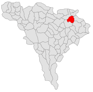
Capella is a municipality located in the province of Huesca, Aragon, Spain. According to the 2009 census (INE), the municipality has a population of 382 inhabitants.
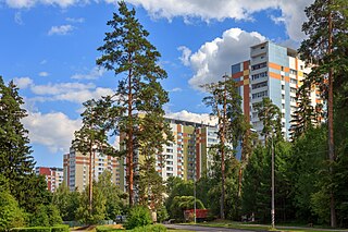
Staroye Kryukovo is a district of Moscow within Zelenogradsky Administrative Okrug.

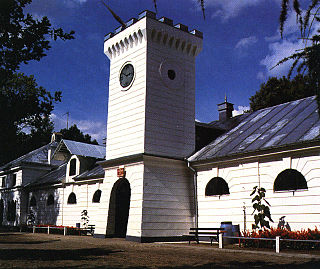
Lazarevskaya railway station is a railway station of the North Caucasus Railway, subsidiary of Russian Railways, located in Lazarevskoye Microdistrict, Lazarevsky City District of the city of Sochi, Krasnodar Krai, Russia. The station was opened in 1918 and was renovated for the 2014 Winter Olympics.


