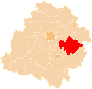
Węgrzynowice is a village in the administrative district of Gmina Budziszewice, within Tomaszów Mazowiecki County, Łódź Voivodeship, in central Poland. It lies approximately 4 kilometres (2 mi) north-east of Budziszewice, 21 km (13 mi) north of Tomaszów Mazowiecki, and 36 km (22 mi) east of the regional capital Łódź.
Ewcin is a village in the administrative district of Gmina Będków, within Tomaszów Mazowiecki County, Łódź Voivodeship, in central Poland. It lies approximately 6 kilometres (4 mi) south-east of Będków, 15 km (9 mi) west of Tomaszów Mazowiecki, and 35 km (22 mi) south-east of the regional capital Łódź.
Chociwek is a village in the administrative district of Gmina Czerniewice, within Tomaszów Mazowiecki County, Łódź Voivodeship, in central Poland. It lies approximately 8 kilometres (5 mi) north-east of Czerniewice, 26 km (16 mi) north-east of Tomaszów Mazowiecki, and 55 km (34 mi) east of the regional capital Łódź.
Podkonice Małe is a village in the administrative district of Gmina Czerniewice, within Tomaszów Mazowiecki County, Łódź Voivodeship, in central Poland. It lies approximately 6 kilometres (4 mi) north-east of Czerniewice, 24 km (15 mi) north-east of Tomaszów Mazowiecki, and 52 km (32 mi) east of the regional capital Łódź.
Stanisławów Lipski is a village in the administrative district of Gmina Czerniewice, within Tomaszów Mazowiecki County, Łódź Voivodeship, in central Poland. It lies approximately 5 kilometres (3 mi) north of Czerniewice, 23 km (14 mi) north-east of Tomaszów Mazowiecki, and 49 km (30 mi) east of the regional capital Łódź.
Wale is a village in the administrative district of Gmina Czerniewice, within Tomaszów Mazowiecki County, Łódź Voivodeship, in central Poland. It lies approximately 9 kilometres (6 mi) north-east of Czerniewice, 27 km (17 mi) north-east of Tomaszów Mazowiecki, and 56 km (35 mi) east of the regional capital Łódź.
Zubki Duże is a village in the administrative district of Gmina Czerniewice, within Tomaszów Mazowiecki County, Łódź Voivodeship, in central Poland. It lies approximately 6 kilometres (4 mi) north-east of Czerniewice, 24 km (15 mi) north-east of Tomaszów Mazowiecki, and 52 km (32 mi) east of the regional capital Łódź.
Zubki Małe is a village in the administrative district of Gmina Czerniewice, within Tomaszów Mazowiecki County, Łódź Voivodeship, in central Poland. It lies approximately 7 kilometres (4 mi) north-east of Czerniewice, 25 km (16 mi) north-east of Tomaszów Mazowiecki, and 53 km (33 mi) east of the regional capital Łódź.
Mikołajów is a village in the administrative district of Gmina Rokiciny, within Tomaszów Mazowiecki County, Łódź Voivodeship, in central Poland. It lies approximately 5 kilometres (3 mi) north of Rokiciny, 25 km (16 mi) north-west of Tomaszów Mazowiecki, and 26 km (16 mi) east of the regional capital Łódź.
Popielawy is a village in the administrative district of Gmina Rokiciny, within Tomaszów Mazowiecki County, Łódź Voivodeship, in central Poland. It lies approximately 18 kilometres (11 mi) north-west of Tomaszów Mazowiecki and 31 km (19 mi) south-east of the regional capital Łódź.
Smardzewice is a village in the administrative district of Gmina Tomaszów Mazowiecki, within Tomaszów Mazowiecki County, Łódź Voivodeship, in central Poland. It lies approximately 4 kilometres (2 mi) south of Tomaszów Mazowiecki and 52 km (32 mi) south-east of the regional capital Łódź.
Wąwał is a village in the administrative district of Gmina Tomaszów Mazowiecki, within Tomaszów Mazowiecki County, Łódź Voivodeship, in central Poland. It lies approximately 4 kilometres (2 mi) south-east of Tomaszów Mazowiecki and 53 km (33 mi) south-east of the regional capital Łódź.
Buków is a village in the administrative district of Gmina Ujazd, within Tomaszów Mazowiecki County, Łódź Voivodeship, in central Poland. It lies approximately 6 kilometres (4 mi) north-west of Ujazd, 16 km (10 mi) north-west of Tomaszów Mazowiecki, and 34 km (21 mi) south-east of the regional capital Łódź.
Helenów is a village in the administrative district of Gmina Ujazd, within Tomaszów Mazowiecki County, Łódź Voivodeship, in central Poland. It lies approximately 7 kilometres (4 mi) west of Ujazd, 16 km (10 mi) north-west of Tomaszów Mazowiecki, and 33 km (21 mi) south-east of the regional capital Łódź.
Lipianki is a village in the administrative district of Gmina Ujazd, within Tomaszów Mazowiecki County, Łódź Voivodeship, in central Poland. It lies approximately 5 kilometres (3 mi) north-west of Ujazd, 16 km (10 mi) north-west of Tomaszów Mazowiecki, and 34 km (21 mi) south-east of the regional capital Łódź.
Młynek is a village in the administrative district of Gmina Ujazd, within Tomaszów Mazowiecki County, Łódź Voivodeship, in central Poland. It lies approximately 6 kilometres (4 mi) north of Ujazd, 16 km (10 mi) north-west of Tomaszów Mazowiecki, and 35 km (22 mi) south-east of the regional capital Łódź.
Ignatów is a village in the administrative district of Gmina Żelechlinek, within Tomaszów Mazowiecki County, Łódź Voivodeship, in central Poland. It lies approximately 4 kilometres (2 mi) north-west of Żelechlinek, 25 km (16 mi) north of Tomaszów Mazowiecki, and 37 km (23 mi) east of the regional capital Łódź.
Petrynów is a village in the administrative district of Gmina Żelechlinek, within Tomaszów Mazowiecki County, Łódź Voivodeship, in central Poland. It lies approximately 4 kilometres (2 mi) south-east of Żelechlinek, 21 km (13 mi) north of Tomaszów Mazowiecki, and 44 km (27 mi) east of the regional capital Łódź.
Radwanka is a village in the administrative district of Gmina Żelechlinek, within Tomaszów Mazowiecki County, Łódź Voivodeship, in central Poland. It lies approximately 7 kilometres (4 mi) east of Żelechlinek, 22 km (14 mi) north of Tomaszów Mazowiecki, and 46 km (29 mi) east of the regional capital Łódź.
Świniokierz Dworski is a village in the administrative district of Gmina Żelechlinek, within Tomaszów Mazowiecki County, Łódź Voivodeship, in central Poland. It lies approximately 3 kilometres (2 mi) south-west of Żelechlinek, 21 km (13 mi) north of Tomaszów Mazowiecki, and 38 km (24 mi) east of the regional capital Łódź.