
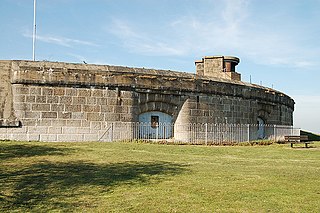
Fort William and Mary was a colonial fortification in Britain's worldwide system of defenses, defended by soldiers of the Province of New Hampshire who reported directly to the royal governor. The fort, originally known as "The Castle," was situated on the island of New Castle, New Hampshire, at the mouth of the Piscataqua River estuary. It was renamed Fort William and Mary circa 1692, after the accession of the monarchs William III and Mary II to the British throne. It was captured by Patriot forces, recaptured, and later abandoned by the British in the Revolutionary War. The fort was renamed Fort Constitution in 1808 following rebuilding. The fort was further rebuilt and expanded through 1899 and served actively through World War II.

The fortifications of Portsmouth are extensive due to its strategic position on the English Channel and role as home to the Royal Navy. For this reason, Portsmouth was, by the 19th century, one of the most fortified cities in the world. The fortifications have evolved over the centuries in response to changes in tactics and technology and the area defended has increased. While the first defences focused on Portsmouth harbour, in step with the fortifications of Gosport, later defensive structures protected the whole of Portsea Island and an increasing distance inland. At the same time, the fortifications of Portsmouth and Gosport became part of the wider fortifications of the Solent. Old Portsmouth, on the southwest corner of Portsea Island, has been walled for much of its history.

Hurst Castle is an artillery fort established by Henry VIII on the Hurst Spit in Hampshire, England, between 1541 and 1544. It formed part of the king's Device Forts coastal protection programme against invasion from France and the Holy Roman Empire, and defended the western entrance to the Solent waterway. The early castle had a central keep and three bastions, and in 1547 was equipped with 26 guns. It was expensive to operate due to its size, but it formed one of the most powerful forts along the coast. During the English Civil War of the 1640s, Hurst was held by Parliament and was used briefly to detain King Charles I before his execution in 1649. It continued in use during the 18th century but fell into disrepair, the spit being frequented by smugglers.

The Western Heights of Dover are one of the most impressive fortifications in Britain. They comprise a series of forts, strong points and ditches, designed to protect the country from invasion. They were created in the 18th and 19th centuries to augment the existing defences and protect the key port of Dover from both seaward and landward attack; by the start of the 20th century Dover Western Heights was collectively reputed to be the 'strongest and most elaborate' fortification in the country. The Army finally withdrew from the Heights in 1956–61; they are now a local nature reserve.

Garrison Point Fort is a former artillery fort situated at the end of the Garrison Point peninsula at Sheerness on the Isle of Sheppey in Kent. Built in the 1860s in response to concerns about a possible French invasion, it was the last in a series of artillery batteries that had existed on the site since the mid-16th century. The fort's position enabled it to guard the strategic point where the River Medway meets the Thames. It is a rare example of a two-tiered casemated fort – one of only two of that era in the country – with a design that is otherwise similar to that of several of the other forts along the lower Thames. It remained operational until 1956 and is now used by the Sheerness Docks as a port installation.

Shornemead Fort is a now-disused artillery fort that was built in the 1860s to guard the entrance to the Thames from seaborne attack. Constructed during a period of tension with France, it stands on the south bank of the river at a point where the Thames curves sharply north and west, giving the fort long views up and downriver in both directions. It was the third fort constructed on the site since the 18th century, but its location on marshy ground led to major problems with subsidence. The fort was equipped for a time with a variety of large-calibre artillery guns which were intended to support two other nearby Thamesside forts. However, the extent of the subsidence meant that it became unsafe for the guns to be fired and the fort was disarmed by the early 20th century.
Coalhouse Fort is an artillery fort in the eastern English county of Essex. It was built in the 1860s to guard the lower Thames from seaborne attack. It stands at Coalhouse Point on the north bank of the river, at a location near East Tilbury which was vulnerable to raiders and invaders. It was the last in a series of fortifications dating back to the 15th century and was the direct successor to a smaller mid-19th century fort built on the same site. Constructed during a period of tension with France, its location on marshy ground caused problems from the start and led to a lengthy construction process. The fort was equipped with a variety of large-calibre artillery guns and the most modern defensive facilities of the time, including shell-proof casemates protected by granite facing and cast-iron shields. Its lengthy construction and the rapid pace of artillery development at the time meant that it was practically obsolete for its original purpose within a few years of its completion.

Beacon Hill Battery is a late-19th and 20th century coastal fortification that was built to defend the port of Harwich, Essex. It is a scheduled ancient monument.

Cliffe Fort is a disused artillery fort built in the 1860s to guard the entrance to the Thames from seaborne attack. Constructed during a period of tension with France, it stands on the south bank of the river at the entrance to Cliffe Creek in the Cliffe marshes on the Hoo Peninsula in North Kent. Its location on marshy ground caused problems from the start and necessitated changes to its design after the structure begin to crack and subside during construction. The fort was equipped with a variety of large-calibre artillery guns which were intended to support two other nearby Thamesside forts. A launcher for the Brennan torpedo—which has been described as the world's first practical guided missile—was installed there at the end of the 19th century but was only in active use for a few years.
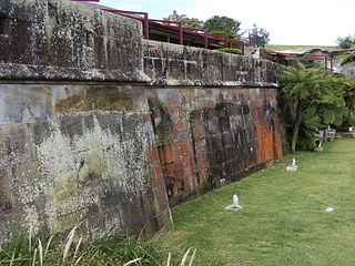
The Georges Head Battery, also called the Georges Head Military Fortifications, is a heritage-listed former military fortification located on the Georges Head on Chowder Bay Road, Georges Heights, in the suburb of Mosman, in the Mosman Council local government area of New South Wales, Australia.

Culver Battery is a former coastal artillery battery on Culver Down, on the eastern side of the Isle of Wight, England. The fortification is one of several Palmerston Forts built on the island following concerns about the size and strength of the French Navy in the late 19th century. It was operational during the First and Second World Wars. The battery was closed in 1956.

Fort Ballance is a former coastal artillery battery on Point Gordon on Wellington's Miramar Peninsula.

Fort Hommet is a fortification on Vazon Bay headland in Castel, Guernsey. It is built on the site of fortifications that date back to 1680, and consists of a Martello tower from 1804, later additions during the Victorian Era, and bunkers and casemates that the Germans constructed during World War II.

Lascaris Battery, also known as Fort Lascaris or Lascaris Bastion, is an artillery battery located on the east side of Valletta, Malta. The battery was built by the British in 1854, and it is connected to the earlier St. Peter & Paul Bastion of the Valletta Land Front. In World War II, the Lascaris War Rooms were dug close to the battery, and they served as Britain's secret headquarters for the defence of the island.

The Gibraltar peninsula, located at the far southern end of Iberia, has great strategic importance as a result of its position by the Strait of Gibraltar where the Mediterranean Sea meets the Atlantic Ocean. It has repeatedly been contested between European and North African powers and has endured fourteen sieges since it was first settled in the 11th century. The peninsula's occupants – Moors, Spanish, and British – have built successive layers of fortifications and defences including walls, bastions, casemates, gun batteries, magazines, tunnels and galleries. At their peak in 1865, the fortifications housed around 681 guns mounted in 110 batteries and positions, guarding all land and sea approaches to Gibraltar. The fortifications continued to be in military use until as late as the 1970s and by the time tunnelling ceased in the late 1960s, over 34 miles (55 km) of galleries had been dug in an area of only 2.6 square miles (6.7 km2).

Fort Tigné is a polygonal fort in Tigné Point, Sliema, Malta. It was built by the Order of Saint John between 1793 and 1795 to protect the entrance to Marsamxett Harbour, and it is one of the oldest polygonal forts in the world. The fort was extensively altered by the British in the 19th century, and it remained in use by the military until 1979.

Fort Davis, is a coastal defence fortification close to Whitegate, County Cork, Ireland. Together with similar structures at Fort Mitchel, Fort Camden (Crosshaven), and Templebreedy Battery, the fort was built to defend the mouth of Cork Harbour. Though used as a fortification from the early 17th century, the current structures of the 74-acre site date primarily from the 1860s. Originally named Fort Carlisle and operated by the British Armed Forces, the fort was handed-over to the Irish Defence Forces in 1938, and renamed Fort Davis. The facility is owned by the Department of Defence, and is used as a military training site with no public access.

Apart from a Roman Fort, there were very few fortifications in Alderney until the mid 19th century. These were then modified and updated in the mid 20th Century by Germans during the occupation period. Alderney at 8 km2 is now one of the most fortified places in the world.

Kissing Point Fortification is a heritage-listed fortification at 38-40 Howitt Street, North Ward, City of Townsville, Queensland, Australia. It was designed by Peter Scratchley and Major Edward Druitt and built from 1891 by A McMillan and then from 1939 to 1941. It is also known as Jezzine Barracks. It was added to the Queensland Heritage Register on 5 February 2010.
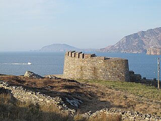
Knockalla Fort is one of several Napoleonic batteries built along the shores of Lough Swilly in county Donegal, to defend the north west of Ireland. It was part of a scheme to fortify Lough Swilly and Lough Foyle against French Invasion during the Revolutionary and Napoleonic Wars and was completed between 1812 and 1813. On the other side of the Lough is Fort Dunree. The fort was built on the site of a temporary fortification first built in 1798.


