
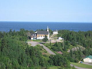
Pointe-aux-Anglais is a hamlet located on the territory of the city of Port-Cartier, on the North shore of the Gulf of St. Lawrence, in Côte-Nord region, Sept-Rivières RCM, Quebec, Canada. [1]
Pointe-aux-Anglais is a hamlet located on the territory of the city of Port-Cartier, on the North shore of the Gulf of St. Lawrence, in Côte-Nord region, Sept-Rivières RCM, Quebec, Canada. [1]
Inside the Roman Catholic Church of the parish of Saint-Paul-de-la-Pointe-aux-Anglais, [2] the Stations of the Cross, is a work of art of famous sculptor Médard Bourgault (1897-1967) of Saint-Jean-Port-Joli. [3] [4]
In 1711, a large fleet commanded by Admiral Walker was sent from England to take Quebec. Due to fog on the St. Lawrence, eight ships grounded on the lle-aux-Oeuf reefs and went down with more than 900 men in one of the worst naval disasters in British history. The point of land just across from the reefs was named Pointe-aux-Anglais to commemorate the ill-fated expedition. It comprises the sectors of Pointe-aux-Anglais and Rivière-Pentecôte. An ecomuseum in Pointe-aux-Anglais explains how the English failed in their attempt to attack Quebec. [5]

Minganie is a regional county municipality on the north shore of the Gulf of St. Lawrence, in Côte-Nord region, Quebec, Canada, its territory includes Anticosti Island.

Sept-Rivières is a regional county municipality of Quebec, Canada, in the Côte-Nord region. Its county seat is Sept-Îles.
The 2000–2006 municipal reorganization in Quebec resulted in large-scale amalgamation of smaller municipalities in Quebec into larger cities. It was undertaken by one administration, but was modified and partially undone by its successor.

Saint-Jean-Port-Joli is a village in the Regional County Municipality of L'Islet within the Chaudière-Appalaches region of Quebec, Canada. It is located on the south shore of the Saint Lawrence River and is the county seat. The village is located off the Trans-Canada Highway, Autoroute 20. Route 132 passes through the town.

Route 138 is a major highway in the Canadian province of Quebec, following the entire north shore of the St. Lawrence River past Montreal to the temporary eastern terminus in Kegashka on the Gulf of St. Lawrence. The western terminus is in Elgin, at the border with New York State south-west of Montreal. Part of this highway is known as the Chemin du Roy, or King's Highway, which is one of the oldest highways in Canada.

Havre-Saint-Pierre is a municipality located on the north shore of the Gulf of St. Lawrence, in Côte-Nord region, Minganie RCM, Quebec, Canada.

Area codes 418, 581, and 367 are telephone area codes in the North American Numbering Plan (NANP) for the eastern portion of the Canadian province of Quebec. Area code 418 was originally assigned to the numbering plan area, but all three area codes now form an overlay plan for this territory. Cities in the numbering plan area include Quebec City, Saguenay, Lévis, Rimouski, Saint-Georges, Alma, Thetford Mines, Sept-Îles, Baie-Comeau and Rivière-du-Loup. Also served are the Gaspé Peninsula, Côte-Nord, southeastern Mauricie, and the tiny hamlet of Estcourt Station, in the U.S. state of Maine.

Port-Cartier is a city in the Côte-Nord region of Quebec, Canada. It is located on the north shore of the St. Lawrence River at the mouth of the Aux-Rochers River, 63 kilometres (39 mi) southwest of Sept-Îles, Quebec.

Rivière-au-Tonnerre, municipality located on the North shore of the Gulf of St. Lawrence, in Côte-Nord region, Minganie Regional County Municipality, in the province of Quebec, Canada.
Rivière-Pentecôte is a village on the north shore of the Gulf of Saint Lawrence, part of the township of Port-Cartier.

Aux Rochers River, is a river in Sept-Rivières Regional County Municipality, Côte-Nord, Quebec, Canada. It drains an area of 4,180 square kilometres (1,610 sq mi). It is a tributary of the Gulf of Saint Lawrence

The Pentecôte River is a river in the Côte-Nord region or the province of Quebec, Canada. It is a tributary of the Gulf of Saint Lawrence, which it enters beside the community of Rivière-Pentecôte.
The Riverin River is a river in the Côte-Nord region of the province of Quebec, Canada. It is a tributary of the Gulf of Saint Lawrence. There is a small hydroelectric power plant near the mouth of the river.
Lake Pasteur is a long and narrow fjord-like lake in the Côte-Nord region of Quebec, Canada.

The Saint-Jean River is a major tributary of the north shore of the Gulf of St. Lawrence, flowing in the unorganized territory of Lac-Jérôme and in the municipality of Rivière-Saint-Jean, in the Minganie Regional County Municipality, in the administrative region of Côte-Nord, in the province of Quebec (Canada). It is considered one of the three salmon rivers on the North Shore.
Loups Marins River is a river in the Côte-Nord region of Quebec, Canada. It empties into the Gulf of Saint Lawrence.
The Dominique River is a river in the Côte-Nord region of Quebec, Canada. It empties into the Gulf of Saint Lawrence.
The Chécatica River is a salmon river in the Côte-Nord region of Quebec, Canada. It empties into the Gulf of Saint Lawrence.
The lac de la Rivière aux Anglais is a freshwater body of the watershed of rivière aux Anglais, flowing in the unorganized territory of Rivière-aux-Outardes, in the Manicouagan Regional County Municipality, in the administrative region of Côte-Nord, in the province from Quebec, to Canada.

Île aux Œufs is an island on the north shore of St. Lawrence River located in Port-Cartier, Quebec, Canada. It is a 19-hectare rocky island resting on a Precambrian bedrock, located two kilometers east of the mainland shore, about five kilometers from the hamlet of Pointe-aux-Anglais and forty kilometers from Pointe-des-Monts. It is mainly covered in balsam fir and includes the fourth-largest colony of common eiders in the St. Lawrence Estuary, as well as a colony of Double-crested Cormorants.
Its name takes that of the point to the north of which the hamlet is located
Discover the wonders of Quebec, a dream destination where wild nature, historical heritage and warm hospitality meet.
Self-taught Quebec sculptor born in Saint-Jean-Port-Joli, on the south shore of the St. Lawrence river
Port-Cartier (Pointe-aux-Anglais) population included with Port-Cartier
49°40′38″N67°10′05″W / 49.67722°N 67.16806°W
| | This Quebec location article is a stub. You can help Wikipedia by expanding it. |