Sept-Rivières | |
---|---|
![]() | |
Coordinates: 50°08′N66°37′W / 50.133°N 66.617°W [1] | |
Country | Canada |
Province | Quebec |
Region | Côte-Nord |
Effective | March 18, 1981 |
County seat | Sept-Îles |
Government | |
• Type | Prefecture |
• Prefect | Denis Miousse |
Area | |
• Total | 33,007.88 km2 (12,744.41 sq mi) |
• Land | 29,527.90 km2 (11,400.79 sq mi) |
Includes native reserves | |
Population (2021) [4] | |
• Total | 34,358 |
• Density | 1.2/km2 (3/sq mi) |
• Pop (2016-21) | ![]() |
• Dwellings | 17,244 |
Includes native reserves | |
Time zone | UTC−5 (EST) |
• Summer (DST) | UTC−4 (EDT) |
Area code(s) | 418 and 581 |
Website | www |
Sept-Rivières (French for "Seven-Rivers") is a regional county municipality of Quebec, Canada, in the Côte-Nord region. Its county seat is Sept-Îles.
The census groups Sept-Rivières RCM with neighbouring Caniapiscau Regional County Municipality into the single census division of Sept-Rivières—Caniapiscau. In the 2021 Canadian census, the combined population was 38,240. [5] The population of Sept-Rivières RCM itself was 34,358, [4] of whom the vast majority live in the city of Sept-Îles.
Sept-Rivières is located in the central part of Côte-Nord. [6] It is bordered by the regional county municipalities of Manicouagan, Caniapiscau, and Minganie, as well as by the southwest corner of Labrador and by the Gulf of Saint Lawrence. It is mostly covered by the Laurentian Mountains. It is a very sparsely populated and undeveloped region with its population highly concentrated along the coast, mostly at Sept-Îles (about three-fourths of the population).
It allegedly takes its name from seven major rivers that join the Saint Lawrence within the territory: Moisie, Sainte-Marguerite, Trinité, Pentecôte, aux Rochers, Pigou and Manitou. But neither the Trinité River nor the Manitou River reaches the Saint Lawrence within the limits of the regional county municipality, and many other rivers could be amongst those "seven rivers".
There are four subdivisions and two native reserves within the RCM: [2]
|
|
|
2021 | |
---|---|
Population | 34,358 (-3.1% from 2016) |
Land area | 29,527.90 km2 (11,400.79 sq mi) |
Population density | 1.2/km2 (3.1/sq mi) |
Median age | |
Private dwellings | 17,244 (total) 15,261 (occupied) |
Median household income |
Year | Pop. | ±% |
---|---|---|
2011 | 35,240 | — |
2016 | 35,441 | +0.6% |
2021 | 34,358 | −3.1% |
Population amounts include native reserves. Source: Statistics Canada |
Highways and numbered routes that run through the municipality, including external routes that start or finish at the county border: [10]
|
|
|
|
There are a number of large rivers that flow in a generally north-south direction through Sept-Rivières to enter the Gulf. Near the coast the river basins tend to narrow in towards the river mouth, and between their mouths are areas that drain into the Gulf through smaller streams. From west to east, the larger river basins, which may cover parts of neighboring regions, are: [11]
River | Basin size | Mouth coordinates | Map link | |
---|---|---|---|---|
km2 | sq. mile | |||
Pentecôte | 1,986 | 767 | 49°46′48″N67°09′52″W / 49.7800000°N 67.1644444°W | EHOZH |
Riverin | 221 | 85 | 49°47′08″N67°09′23″W / 49.7855556°N 67.1563889°W | EHWEN |
Aux Rochers | 4,161 | 1,607 | 50°01′10″N66°52′07″W / 50.0194444°N 66.8686111°W | EHWSX |
Dominique | 263 | 102 | 50°01′35″N66°52′05″W / 50.0263889°N 66.8680556°W | EGEDF |
Sainte-Marguerite | 6,213 | 2,399 | 50°08′34″N66°35′48″W / 50.1427778°N 66.5966667°W | EJGWT |
Rapides | 573 | 221 | 50°16′07″N66°27′26″W / 50.2686111°N 66.4572222°W | EHURW |
Moisie | 19,273 | 7,441 | 50°12′00″N66°04′03″W / 50.2000000°N 66.067500°W | EHHGN |
Matamec | 679 | 262 | 50°17′01″N65°58′00″W / 50.2836111°N 65.9666667°W | EHEPE |
Loups Marins | 186 | 72 | 50°15′33″N65°44′40″W / 50.259167°N 65.744444°W | EHBME |
Pigou | 169 | 65 | 50°16′13″N65°37′38″W / 50.2702778°N 65.6272222°W | EHQOC |
La Haute-Gaspésie is a regional county municipality in the Gaspésie–Îles-de-la-Madeleine region of eastern Quebec, Canada, on the Gaspé peninsula. The regional county municipality seat is in Sainte-Anne-des-Monts.
Deux-Montagnes is a regional county municipality in the Laurentides region of Quebec, Canada. It is located immediately north of Laval on the north shore of the Rivière des Mille-Îles and on the north shore of the Lake of Two Mountains. Its seat and largest city is Saint-Eustache.
La Rivière-du-Nord is a regional county municipality in the Laurentides region of Quebec, Canada. The seat is in Saint-Jérôme. It is named for the river that runs through it, the Rivière du Nord.
Les Jardins-de-Napierville is a regional county municipality (RCM) in southwestern Quebec, Canada, in the Montérégie region. Founded on January 1, 1982. Its seat is Napierville.
Les Moulins is a regional county municipality in the Lanaudière region of Quebec, Canada.
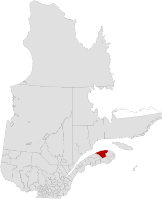
La Matanie is a regional county municipality, located in the Bas-Saint-Laurent region of Quebec, in Canada. From January 1, 1982, to March 9, 2013, it was known as Matane.
Minganie is a regional county municipality on the north shore of the Gulf of St. Lawrence, in Côte-Nord region, Quebec, Canada, its territory includes Anticosti Island.
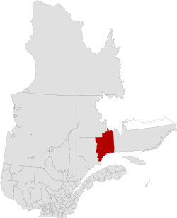
Rivière-du-Loup is a regional county municipality in the Bas-Saint-Laurent region of Quebec, Canada. Its most important city is Rivière-du-Loup, which contains more than half of the population.
Thérèse-De Blainville is a regional county municipality in the Laurentides region of Quebec, Canada. It is located immediately north of Laval on the north shore of the Rivière des Mille-Îles.
Caniapiscau is a regional county municipality in the Côte-Nord region of Quebec, Canada. The seat is Fermont.
Les Chenaux is a regional county municipality in central Quebec, Canada, in the Mauricie region. The seat is in Saint-Luc-de-Vincennes. It is located adjacent on the east of Trois-Rivières on the Saint Lawrence River. It has a land area of 872.04 square kilometres (336.70 sq mi) and a population of 17,865 inhabitants in the Canada 2011 Census. Its largest community is the parish of Notre-Dame-du-Mont-Carmel.
Fermont is a mining city in Côte-Nord region, Quebec, Canada, near the Quebec-Labrador border about 23 kilometres (14 mi) from Labrador City on Route 389, which connects to the Trans-Labrador Highway. It is the seat of the Regional County Municipality of Caniapiscau.
Saint-Clément is a municipality in the Canadian province of Quebec, located in Les Basques Regional County Municipality in the Bas-Saint-Laurent region.
L'Ange-Gardien is a municipality in the Capitale-Nationale region of Quebec, Canada. It is part of La Côte-de-Beaupré Regional County Municipality.
Notre-Dame-des-Sept-Douleurs is an island municipality in the Bas-Saint-Laurent region of Quebec, Canada, part of the Rivière-du-Loup Regional County Municipality. It is located on and contiguous with Île Verte in the Estuary of St. Lawrence, about 20 kilometres (12 mi) north-east of Rivière-du-Loup. The name Île Verte was given in 1621 by Samuel de Champlain written "Isle Verte".
Rivière-au-Tonnerre, municipality located on the North shore of the Gulf of St. Lawrence, in Côte-Nord region, Minganie Regional County Municipality, in the province of Quebec, Canada.
Sept-Rivières—Caniapiscau is a census division (CD) of Quebec, with geographical code 97. It consists of the regional county municipalities of Sept-Rivières and Caniapiscau.
Rivière-Nipissis is an unorganized territory in the Côte-Nord region of Quebec, Canada, part of the Sept-Rivières Regional County Municipality.
Le Golfe-du-Saint-Laurent is a regional county municipality in the Côte-Nord region of far-eastern Quebec, Canada. It includes all communities along the Gulf of Saint Lawrence between the Natashquan River and the Newfoundland and Labrador border.
Proposed Regional Park, Seven Islands Archipelago, Zec de la Rivière-Moisie, Proposed Groulx Mountains Biodiversity Reserve