Location
Lake Quatre Lieues is in the unorganized territory of Lac-Walker in the Sept-Rivières Regional County Municipality of the Côte-Nord administrative region of Quebec. It is in the extreme south of the proposed Lake Walker National Park. The MacDonald River flows through the northern end of Lake Quatre Lieues and continues east to join the Aux Rochers River to the south of Lake Walker. The lake is about 116 metres (381 ft) above sea level.
The northern part of the lake is 4.8 kilometres (3.0 mi) long and 390 metres (1,280 ft) wide. It lies in a slender lacustrine basin 5.2 kilometres (3.2 mi) long by 2 kilometres (1.2 mi) wide with bays and sandbanks, an extension of the Lake Walker basin. The surrounding terraces are formed of sandy materials of deltaic origin. These deposits were laid down during glacial decay in the Holocene. The southern extension forms a narrow and winding basin 16 kilometres (9.9 mi) long cut into the plateau.
The Cartier Railway owned by ArcelorMittal runs along the northeast shore of the lake before turning west along the MacDonald River valley. The railway links the Mont Wright iron mine near Fermont to Port-Cartier.

Lake Walker is a lake in Quebec, Canada. It is located in the Sept-Rivières Regional County Municipality in the region of Côte-Nord, about 30 km northwest of Port-Cartier.
The ZEC Matimek is a "zone d'exploitation contrôlée" (ZEC) in the unorganized territory of Lac-Walker, in the Sept-Rivières Regional County Municipality (MRC), in the administrative region of Côte-Nord, in Quebec, in Canada. Zec Matimek was created in 1979.

Aux Rochers River, is a river in Sept-Rivières Regional County Municipality, Côte-Nord, Quebec, Canada. It drains an area of 4,180 square kilometres (1,610 sq mi). It is a tributary of the Gulf of Saint Lawrence
Lac Terant is a small lake in the Côte-Nord region of the province of Quebec, Canada. It drains to the west into Lake Sainte-Anne.

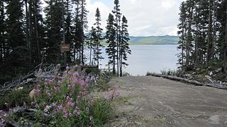
Lake Walker National Park is a proposed national park in the province of Quebec, Canada, centered on the 33 kilometres (21 mi) long Lake Walker.

The MacDonald River is a river in Quebec, Canada, to the north of the lower Saint Lawrence River. It is known for its dramatic cascade, the Chute MacDonald.
The Ronald River is a river in the Côte-Nord region of Quebec, Canada. It is a left tributary of the MacDonald River.

Lake Arthur is a lake in Quebec, in Port-Cartier–Sept-Îles Wildlife Reserve in the Côte-Nord region.
The Schmon River is a river in the Côte-Nord region of the province of Quebec, Canada. It flows south into Lake Walker.
The Northeast Toulnustouc River is a tributary of the Toulnustouc River in Lac-Walker, Sept-Rivières, Côte-Nord, Quebec, Canada. The Cartier Railway runs beside it for most of its length.

The Pentecôte River is a river in the Côte-Nord region or the province of Quebec, Canada. It is a tributary of the Gulf of Saint Lawrence, which it enters beside the community of Rivière-Pentecôte.
The Pasteur River is a river in Quebec, Canada, to the north of the lower Saint Lawrence River. It is a tributary of the Aux Rochers River in the Lac-Walker territory of Côte-Nord. For most of its length it flows through the proposed Lake Walker National Park. The lower section of the river includes the 21 kilometres (13 mi) long Lake Pasteur.
The Gravel River is a river in Quebec, Canada, to the north of the lower St. Lawrence River. It is a tributary of the Aux Rochers River in the Lac-Walker territory of Côte-Nord.

The Godbout River is a river in the Côte-Nord region of Quebec, Canada, that flows into the Estuary of Saint Lawrence beside the village of Godbout.
Lake Cacaoui is a lake in the Côte-Nord region of Quebec, Canada. It drains into the Sainte-Marguerite River.

The Trinité River, or Grande Trinité River is a river in the Côte-Nord region of Quebec, Canada. Salmon fishing is allowed, subject to limits.
Lake Nipisso is a 40 square kilometres (15 sq mi) lake in a remote part of the Côte-Nord region of Quebec, Canada.
The Lake Pasteur Biodiversity Reserve is a proposed biodiversity reserve in the Côte-Nord region of Quebec, Canada.
Lake Pasteur is a long and narrow fjord-like lake in the Côte-Nord region of Quebec, Canada.
The Dominique River is a river in the Côte-Nord region of Quebec, Canada. It empties into the Gulf of Saint Lawrence.
This page is based on this
Wikipedia article Text is available under the
CC BY-SA 4.0 license; additional terms may apply.
Images, videos and audio are available under their respective licenses.
