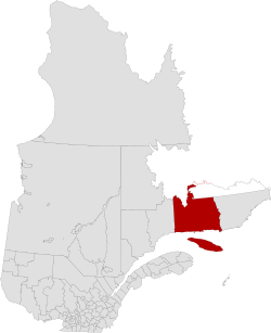
Historical census populations – Minganie Regional County Municipality
Year
Pop.
±%
2011
6,613
—
2016
6,587
−0.4%
2021
6,467
−1.8%
Population amounts include native reserves. Source: Statistics Canada
Transportation
Sea - Air - Ground
Until the arrival of The Whale Route(Route 138)[9][10] in 1976 and 1996, the only regular means of access to the area was the boat service maintained during the navigation season by Clarke Steamship Company, Ltd.[11] The regularity of the service becomes more and more uncertain from the month of September, depending on the date of the arrival of winter with its snow, ice, storms and fog. However, it is possible to reach the area by chartering seaplanes that can easily land under favourable atmospheric conditions in many deep bays and on windward waters sheltered by islands.[12]
Route & trails
Highways and numbered routes that run through the RCM, including external routes that start or finish on its borders.[13]
In 2024, the Côte-Nord region is part of the network of the 33 000 km of trails of The Federation of Snowmobile Clubs of Quebec and La Minganie Snowmobile Club, based in Les Escoumins,[14] offer detailed interactive maps on the different circuits and their points of services.
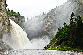
There are a number of large rivers that flow in a generally north–south direction through Minganie to enter the Gulf. Near the coast the river basins tend to narrow in towards the river mouth, and between their mouths are areas that drain into the Gulf through smaller streams. From west to east, the larger river basins, which may cover parts of Labrador, Sept-Rivières or Le Golfe-du-Saint-Laurent, are:[15]
Frère Marie-Victorin (1885–1944), Mingan archipelago 1928, in hand, the C. minganense (large pale plant, with flower heads gathered in a mass surpassed by the leaves
With the exception of a few enclaves, the ecological region of Minganie is mainly covered by large Spruce forests and a few laricinin fields (Larix laricina (Du Roi) K. Koch). There are also White spruce (Picea glauca (Moench) Voss.), Dwarf birch (Betula glandulosa Minchx), Rough alder (Alnus rugosa (DuRoi Spreng.) and Trembling aspen (Populus tremuloides Michaux).[16]
Brothers Marie-Victorin and Rolland Germain F.E.C. explored the region from 1924 to 1928. Their work has raised awareness in the scientific community of the enormous value of the Mingan Archipelago. Since then, other scientists have added to the ecology and phytogeography knowledge of this sector.[17]
The vegetation of the Mingan Islands belongs to the Chibougamau-Natashquan boreal forest region, which is dominated by Black spruce. The high latitude and low altitude, combined with the proximity of the cold currents of Labrador, explain the subarctic vegetation specific to the Minganie.
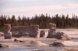
The entirely calcareous nature of the horizontal stratified rocks, which make up the Anticosti - Minganie, exerts a profound influence on the structure of the flora and on the choice of species.
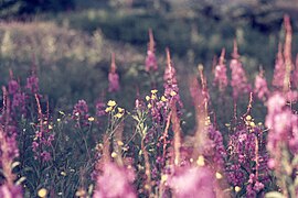
Remarkable for its richness, the flora includes 350 vascular plants including the presence of two rare taxa: Cirsium foliosum var. Minganense and Cypripedium passerinum var. Minganense. Sixty species are new to the list of Minganie harvests compiled by Marie-Victorin and Rolland-Germain (1969). There were also 150 bryophytes and 152 lichens, 29 of which were additions to the Nouveau Catalogue des lichens, published by Lepage (1972).[18][19]
During the summers of 1964 and 1965, during geological research, Jean Depatie with a team of geologists and students, assisted by 3 canoemen and lumberjacks, plus a cook, explored 440 square miles of a territory stretching from Sept-Îles to Blanc Sablon, in the Lac à l'Ours region. In the field, scientists noted an abundance of Canadian beavers, a few otters and American mink, many hares, partridges and a multitude of ducks. Caribou and moose are scarce while black bears and red foxes abound.[20]
↑ "Minganie, toponymy". Quebec Gouvernement (in French). Quebec Toponymy Commission. 7 March 1985. Retrieved 24 June 2024. The Mingan archipelago and the adjoining coastline, famous for their limestone erosion patterns, and Anticosti Island, which forms a small world in itself, remain the great natural features of the Mingan region.
↑ "Visit Minganie" (in French). Regional County Municipality of Minganie. 3 June 2024. Retrieved 23 June 2024. Between the boreal forest and the Gulf of the St. Lawrence River, only the immensity of the sky equals the grandeur of this vast region.
↑ Ministry of Culture and Communications of Quebec (2006). "Johan Beetz House, heritage real estate". Heritage directory cultural of Quebec. Retrieved 18 June 2024. Other name, Château Johan-Beetz
↑ "Whales of the St. Lawrence river". Whales Online. 2024. Retrieved 18 April 2024. The estuary is home to belugas all year round. In summer, the estuary also hosts rorquals and other species of toothed whales that benefit from the abundance of krill, capelin and other small fish.
↑ "The Clarke Steamship Co Ltd"(PDF). 7 June 2014. pp.41 of 74. Retrieved 17 May 2024. The North Shore service now sailed from Quebec every Tuesday at 9 am, serving no fewer than thirty locales, consisting of pulpwood ports, native villages, trading posts and fishing settlements,
↑ Jacques Claveau (1950). "The North Shore of the St. Lawrence, from Aguanish to Washicoutai Bay, Saguenay County"(PDF) (in French). Ministère de l'Énergie et des Ressources naturelles - Gouvernement du Québec. pp.8 of 78. Retrieved 18 May 2024. Aguanish is about 515 miles downstream from the city of Quebec and about 90 miles due east of the village of Mingan.
↑ "La Minganie Snowmobile Club". Côte-Nord entre nature et démesure. 2024. Retrieved 15 May 2024. In order to preserve our magnificent North Shore in its wild state, we invite you to adopt the principles of the Leave No Trace code of ethics.
↑ Ministry of Natural Resources and Wildlife, Forêt Québec, Forest Inventory Branch (July 2007). "Guide to the Recognition of Ecological Types: Ecological Region Anticosti Island, Mingan Islands"(PDF) (in French). Quebec Gouvernement. Retrieved 19 January 2024. an ecological region is a homogeneous unit in relation to the dynamics of vegetation and variables in the physical environment{{cite web}}: CS1 maint: multiple names: authors list (link)
↑ Marie-Victorin (1885–1944) (2003). "Avant-pays Anticosti-Minganie". florelaurentienne.com (in French). pp.56 of 920. Retrieved 19 January 2024. Because of the importance and biological autonomy of this archipelago, we have given it the name of Minganie{{cite web}}: CS1 maint: numeric names: authors list (link)
↑ "Flora of a thousand faces". Mingan Archipelago National Park Reserve. Gouvernement of Canada. 29 May 2014. Retrieved 19 January 2024. The woodlands of the Mingan Islands are made up of Balsam Fir ( Abies balsamea ), Black Spruce ( Picea mariana ) and White Spruce ( Picea glauca ).
↑ Line Couillard and Pierre Grondin (3 January 2023). "The rare plants of Mingan archipelago"(PDF). Environnement Canada Parks. Retrieved 19 January 2024. picking of all plants is strictly prohibited in national parks.
↑ Jean Depatie (1967). "Preliminaty Report on L'Ours lake area"(PDF). Ministère de l'Énergie et des Ressources naturelles - Gouvernement du Québec. p.21. Retrieved 29 January 2024. This study focuses on several coastal islands, which are part of the Mingan Archipelago, and covers 400 square miles of Duplessis County
↑ George Kolenosky (1992). "Black bear"(PDF). Minister of Environment, Minister of Supply and Services Canada. Retrieved 30 January 2024. Favourite fruits include blueberries, buffalo berries, strawberries, elderberries, saskatoons, black cherries, and apples.
↑ Parks Canada (2022-11-19). "Mingan Archipelago National Park Reserve". Government of Canada. Retrieved 2024-01-16. Seabirds, Seals, Whales, Land Mammals, occasionally, Black Bears and Moose
↑ "Mingan Island Cetacean Study (MICS)". 2024. Retrieved 31 January 2024. The principal study areas include the Quebec North Shore in the Mingan Island / Anticosti region, the Gaspe Peninsula and St. Lawrence Estuary.
↑ "St. Lawrence Estuary Marine Protected Area (MPA) Project"(PDF). Fisheries and Oceans Canada. March 2010. pp.13 of 76. Retrieved 31 January 2024. Nearly half a dozen marine mammal species found in the estuary regularly or occasionally are species at risk listed
↑ Park Canada (2019-10-24). "Betchouane Migratory Bird Sanctuary". Government of Canada. Retrieved 30 January 2024. this sanctuary including large numbers of razorbill, Atlantic puffin, herring gull and great black-backed gull. Black-legged kittiwake and black guillemot
↑ "Bird Watching in Côte-Nord". Quebec by the sea. Retrieved 30 January 2024. Côte-Nord is home to hundreds of bird species.
↑ Government of Canada (2020-12-24). "Marine Birds". Parks Canada. Retrieved 2024-01-18. In order to ensure the reproductive success of these birds, certain islands or sectors of the islands are closed to public during the nesting period
This page is based on this Wikipedia article Text is available under the CC BY-SA 4.0 license; additional terms may apply. Images, videos and audio are available under their respective licenses.