Fishing
Lac Holt Fishing Lodge provides access to the Watshishou, Big Holt and Little Holt lakes, and can be reached by float plane from Havre-Saint-Pierre. The lodge offers fishing from boats or wading below rapids. Fish include brook trout (Salvelinus fontinalis), Arctic char (Salvelinus alpinus), and landlocked Atlantic salmon (Salmo salar). A 2018 North Atlantic Salmon Conservation Organization (NASCO) Rivers Database Report gave the status of the river as "Not Threatened With Loss".
In May 2015 the Ministry of Forests, Wildlife and Parks of Quebec announced a sport fishing catch-and-release program for large salmon on sixteen of Quebec's 118 salmon rivers. These were the Mitis, Laval, Pigou, Bouleau, aux Rochers, Jupitagon, Magpie, Saint-Jean, Corneille, Piashti, Watshishou, Little Watshishou, Nabisipi, Aguanish and Natashquan rivers. The Quebec Atlantic Salmon Federation said that the measures did not go nearly far enough in protecting salmon for future generations. In view of the rapidly declining Atlantic salmon population catch-and-release should have been implemented on all rivers apart from northern Quebec.

The Magpie River, Moteskikan Hipu, Mutehekau Hipu, Pmotewsekaw Sipo, Rivière Magpie (French), it flows from north to south, emptying into Magpie Bay, Gulf of St. Lawrence, in Rivière-Saint-Jean municipality, Minganie RCM, Côte-Nord, Quebec, Canada.

The Natashquan is a river in the Canadian provinces of Quebec and Newfoundland and Labrador. It flows south into the Gulf of Saint Lawrence.

The Romaine River, Kanatuahkuiau, Uanaman Hipu, Uepatauekat Shipu, the river traditional indigenous variants, Rivière Romaine in French, it flows from north to south, emptying into the Jacques Cartier Strait, the Gulf of St. Lawrence and Havre-Saint-Pierre municipality.

Aux Rochers River, is a river in Sept-Rivières Regional County Municipality, Côte-Nord, Quebec, Canada. It drains an area of 4,180 square kilometres (1,610 sq mi). It is a tributary of the Gulf of Saint Lawrence
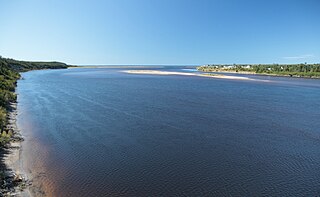
The Little Watshishou River is a salmon river in the east of the Côte-Nord region of Quebec, Canada.
The Nabisipi River Old Forest is a protected area of old-growth forest in the Côte-Nord region of Quebec, Canada. It is classified as an exceptional forest ecosystem.

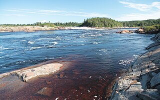
The Nabisipi River is a salmon river in the Côte-Nord region of Quebec, Canada. It flows into the Gulf of Saint Lawrence
The Lake Davy Old Forest is a protected area of old-growth forest in the Côte-Nord region of Quebec, Canada. It is classified as an exceptional forest ecosystem.
The Pigou River is a salmon river in the Côte-Nord region of Quebec, Canada. It empties into the Gulf of Saint Lawrence.

The Jupitagon River is a salmon river in the Côte-Nord region of Quebec, Canada. It flows south through boreal forests from the Canadian Shield to the Gulf of Saint Lawrence. In 2018 salmon fishing was banned on the river due to critically low stocks.
The Olomane River is a river in the Côte-Nord region of Quebec, Canada.
The Saint-Jean River, Usasumekw, Patamo, Rivière Saint-Jean (French), is a salmon river that flows from north to south, emptying into the Gulf of St. Lawrence, in Rivière-Saint-Jean municipality, Minganie RCM, Côte-Nord, Quebec, Canada.
The Véronique River is a river in the Côte-Nord region of the province of Quebec, Canada. It flows into the Gulf of Saint Lawrence, opposite to Anticosti Island.

Piashti River is a salmon river, tributary of the Gulf of St. Lawrence, located in Baie-Johan-Beetz municipality, Minganie RCM, Côte-Nord region, Quebec, Canada.

The Corneille River is a river in the Côte-Nord region of Quebec, Canada. It empties into the Gulf of Saint Lawrence opposite Anticosti Island.

The Pashashibou River is a river in the Côte-Nord region of Quebec, Canada. It flows into the Gulf of Saint Lawrence.
The Aguanish River, Aguanus River official name until 1985,, is a salmon river that flows from north to south, emptying into the Jacques Cartier Strait, the Gulf of St. Lawrence and Aguanish municipality, in Minganie RCM, Côte-Nord region, Quebec, Canada.
The Belles Amours River is a salmon river in the Côte-Nord region of Quebec, Canada. It empties into the Gulf of Saint Lawrence.

The Kécarpoui River is a salmon river in the Côte-Nord region of Quebec, Canada. It flows south and empties into the Gulf of Saint Lawrence.
The Washicoutai River is a salmon river in the Côte-Nord region of Quebec, Canada. It flows south and empties into the Gulf of Saint Lawrence.

