Fishing
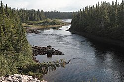
The La Corneille outfitter has exclusive fishing rights to 19 kilometres (12 mi) of the Corneille River. They provide accommodation, and easy access to productive Atlantic salmon pools. There is also plentiful brook trout. The outfitter is based on a granite island at the confluence of the Corneille River and the Gulf of St. Lawrence. It is 60 kilometres (37 mi) east of Havre-St-Pierre, accessible by car along Quebec Route 138. The island is in the Mingan Archipelago National Park Reserve.
Only the first 9.3 kilometres (5.8 mi) of the river is readily accessible to salmon, which cannot pass a waterfall 5.6 metres (18 ft) high at the confluence of Lake Tanguay and the Corneille River. In 2014 a program funded by Hydro-Québec as part of the development of the Romaine River hydroelectric project built a path by which the salmon could pass this obstacle. Controlled blasting in the bedrock created an excavated channel near the left bank that carried about 10% of the river's flow to create a salmon run. This gave the fish access to an additional 60 kilometres (37 mi) of the river, and reduced the time they spent at the foot of the falls, where they were at risk of poaching.
Follow-up activities include inventories using electrical fishing, a scientific research project to measure the interaction between the salmon and other fish species in the upstream section, including landlocked salmon, and a camera system to monitor several sites where intruders could access the river for illegal fishing.
In May 2015 the Ministry of Forests, Wildlife and Parks of Quebec announced a sport fishing catch-and-release program for large salmon on sixteen of Quebec's 118 salmon rivers. These were the Mitis, Laval, Pigou, Bouleau, Aux Rochers, Jupitagon, Magpie, Saint-Jean, Corneille, Piashti, Watshishou, Little Watshishou, Nabisipi, Aguanish and Natashquan rivers. The Quebec Atlantic Salmon Federation said that the measures did not go nearly far enough in protecting salmon for future generations. In view of the rapidly declining Atlantic salmon population catch-and-release should have been implemented on all rivers apart from northern Quebec.

Aux Rochers River, is a river in Sept-Rivières Regional County Municipality, Côte-Nord, Quebec, Canada. It drains an area of 4,180 square kilometres (1,610 sq mi). It is a tributary of the Gulf of Saint Lawrence

The rivière au Tonnerre is a watercourse that runs through the municipality of Rivière-au-Tonnerre, Quebec in the Minganie Regional County Municipality (RCM), in the Côte-Nord administrative region, in Quebec, in Canada. The course of the river crosses the township of Margane, then constitutes the boundary between the townships of Margane and Touzel until the confluence of the river with the North shore of the Gulf of Saint Lawrence.
The Little Watshishou River is a salmon river in the east of the Côte-Nord region of Quebec, Canada.

The Watshishou River is a salmon river in the east of the Côte-Nord region of Quebec, Canada.

The Nabisipi River is a salmon river in the Côte-Nord region of Quebec, Canada. It flows into the Gulf of Saint Lawrence
The Pigou River is a salmon river in the Côte-Nord region of Quebec, Canada. It empties into the Gulf of Saint Lawrence.

The Jupitagon River is a salmon river in the Côte-Nord region of Quebec, Canada. It flows south through boreal forests from the Canadian Shield to the Gulf of Saint Lawrence. In 2018 salmon fishing was banned on the river due to critically low stocks.
The Gros Mécatina River is a salmon river in the Côte-Nord region of Quebec, Canada. It empties into the Gulf of Saint Lawrence.
The Coacoachou River is a river in the Côte-Nord region of Quebec, Canada.
The Olomane River is a river in the Côte-Nord region of Quebec, Canada.
The Véco River is a salmon river in the Côte-Nord region of Quebec, Canada, that empties into the Gulf of Saint Lawrence. It has been dammed to supply a hydroelectric power plant. The shoreline around the mouth of the river is protected as part of a federal bird sanctuary.
The Saint-Jean River, Usasumekw, Patamo, Rivière Saint-Jean (French), is a salmon river that flows from north to south, emptying into the Gulf of St. Lawrence, in Rivière-Saint-Jean municipality, Minganie RCM, Côte-Nord, Quebec, Canada.
The Véronique River is a river in the Côte-Nord region of the province of Quebec, Canada. It flows into the Gulf of Saint Lawrence, opposite to Anticosti Island.

Piashti River is a salmon river, tributary of the Gulf of St. Lawrence, located in Baie-Johan-Beetz municipality, Minganie RCM, Côte-Nord region, Quebec, Canada.

The Sheldrake River is a river in the Côte-Nord region of Quebec, Canada. It flows into the Gulf of Saint Lawrence. There is a 25 MW hydroelectric power station on the river.

The Pashashibou River is a river in the Côte-Nord region of Quebec, Canada. It flows into the Gulf of Saint Lawrence.

The Quetachou River is a river in the Côte-Nord region of the province of Quebec, Canada. It empties into the Gulf of Saint Lawrence.
Mingan River is a 117-kilometre (73 mi) salmon river of the Côte-Nord region of Quebec. It flows from north to south and empties into the Gulf of Saint Lawrence.

The Kécarpoui River is a salmon river in the Côte-Nord region of Quebec, Canada. It flows south and empties into the Gulf of Saint Lawrence.
The Washicoutai River is a salmon river in the Côte-Nord region of Quebec, Canada. It flows south and empties into the Gulf of Saint Lawrence.
This page is based on this
Wikipedia article Text is available under the
CC BY-SA 4.0 license; additional terms may apply.
Images, videos and audio are available under their respective licenses.