The reserve is accessible via Quebec Route 138, 10 kilometers (6.2mi) east of the village of Longue-Pointe-de-Mingan and 36 kilometers (22mi) west of downtown Havre-Saint-Pierre. It is serviced by a health centre, community radio station, library, cultural centre, community store, municipal water and sewer system, fire station, and an aboriginal police force.[3]
The name Mingan, already appearing as mican on a map of 1631, is generally considered to originate from the Innu word maikan, meaning "timber wolf". But there is no certainty over this interpretation. It has also been proposed that it may have come from the Basque word mingain meaning "language", or the Breton term menguen that translates as "white stone".[4]
History
Naskapi Aboriginal people at the Hudson Bay's Post at Mingan, 1862
Historically, the region was the homeland of the Innu people, who came there from their inland hunting grounds to spend the summer on the coast. Mingan was a summer gathering site where the Innu would fish for salmon, hunt for whale, have family meetings, and trade with each other. In 1661 the Mingan Seignory was granted and Europeans began to settle in the area, marking the beginnings of the fur trade, which continued until the early 20th century. The North West Company and then the Hudson's Bay Company (from 1807 to 1873) maintained trading posts there under the name Mingan, which were frequently visited by Innu to trade furs, although they continued to stay there during the summers only.[5]
Aboriginal group at Mingan, 1920
The Innu's nomadic way of life was disrupted during World War II, as mining and forestry companies moved into the area. After the war, mandatory education, fluctuating fur prices, and government housing programs led the Innu to settle permanently there.[5]
On April 30, 1963, the Government of Québec transferred 7 square miles (18km2) of land in the seignory of Mingan to the Government of Canada to establish a reserve for the Mingan region Innu. The reserve however had no access to the Mingan River, which the Innu depended on for subsistence. After many years of struggle, the river banks were added to the reserve in 1983. In 1996, it was further expanded.[5][6]
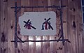
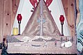
St. George's Church, catholic Innu Mission, was built in the years 1917-1918 by John Maloney, and is entirely decorated with works created by Innu and Montagnais artists from Ekuanitshit.[11][12]
Cultural heritage: Ekuanitshit/St Georges de Mingan church
There is only one school on the reserve, École Teueikan, that provides pre-Kindergarten to Secondary grade 4, and had an enrollment of 106 students in 2008–2009.
1 2 "Crown-Indigenous Relations and Northern Affairs Canada". Government of Canada. 2023-11-29. Retrieved 21 January 2024. modernize Government of Canada structures to enable Indigenous peoples to build capacity and support their vision of self-determination
↑ "Mingan". Commission de toponymie Quebec (in French). Government of Quebec. 1986-12-18. Retrieved 22 January 2024. Despite the Innu's frequent use of the site, they did not obtain a reserve until 1963.
↑ Pierre Camu (1959). "Ports in the province of Quebec"(PDF). Quebec geography notebooks (in French). Department of Geography at Laval University. pp.3 of 10. Retrieved 13 October 2024. Ports of the Gulf of St. Lawrence, on the Côte-Nord Shore: Blanc-Sablon, Harrington Harbor, Natashquan, Havre-Saint-Pierre, Mingan, Port-Menier (Anticosti Island), Cap-aux-Meules (Îles-de-la -Madeleine)
↑ "Church of St. George Mingan". catholic.org. 2023-12-08. Retrieved 22 January 2024. Jurisdiction: Diocese of Baie-Comeau 15, rue Mistamehkanau, Mingan
↑ "Church of St. George". Quebec Ministry of Culture and Communications (in French). Heritage directory cultural of Quebe. 2024. Retrieved 6 July 2024. Includes, ambo, altar, baptismal font, candle holder
This page is based on this Wikipedia article Text is available under the CC BY-SA 4.0 license; additional terms may apply. Images, videos and audio are available under their respective licenses.