
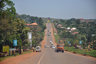
Ombella-M'Poko is one of the 16 prefectures of the Central African Republic. Its capital is Bimbo. One important tourist attraction is the Falls of Baoli; however, due to the Baoli dam, the falls only carry water on the weekends.

The Chinhoyi Caves are a group of limestone and dolomite caves in north central Zimbabwe. Designated a National Park in 1955, and managed by the Zimbabwe Parks & Wildlife Management Authority.
In many countries, kilometre zero or similar terms in other languages is a particular location from which distances are traditionally measured. Historically, they were markers where drivers could set their odometers to follow the directions in early guide books.

Bimbo is the capital of Ombella-M'poko, one of the 14 prefectures of the Central African Republic, and is located 25.5 kilometres (15.8 mi) by road southwest of the centre of the capital, Bangui. The country's second-largest city, Bimbo had a population of 124,176 as of the 2003 census and a calculated 2013 population of 267,859.

Bangui M'Poko International Airport is an international airport located seven kilometres (4.3 mi) northwest of Bangui, capital of the Central African Republic.
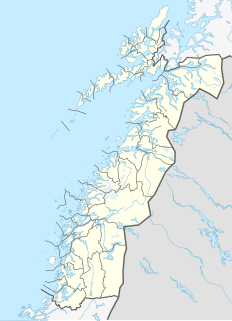
Alsvågvatnet is a lake which lies in Øksnes Municipality in Nordland county, Norway. It is on the island of Langøya in the Vesterålen archipelago. There is birch woodland and bogland nearby. The 2.36-square-kilometre (0.91 sq mi) lake sits at an elevation of 8 metres (26 ft) above sea level, about 1.3 kilometres (0.81 mi) west of the village of Alsvåg, along the road to Myre.
Valnesvatnet is a lake that lies in the municipality of Bodø in Nordland county, Norway. The 4.91-square-kilometre (1.90 sq mi) lake lies along the Norwegian County Road 17 about 1 kilometre (0.62 mi) north of the border with Gildeskål Municipality, just northeast of the village of Nygårdsjøen. The water in the lake flows out over the Valnesfossen waterfall on its way to the sea.

Nilsebuvatnet is a lake in the municipalities of Sandnes and Hjelmeland in Rogaland county, Norway. The 2.47-square-kilometre (0.95 sq mi) lake lies in the Lyseheiane mountains about 13 kilometres (8.1 mi) north of the village of Lysebotn and about 25 kilometres (16 mi) east of the village of Årdal. The lake is regulated by a small dam on the southwest corner of the lake. The dam provides water for the Lysebotn power station. The lake drains out into the river Storåna which flows westward towards Årdal. The lake is accessible by a small service road from Lysebotn which leads up to the dam.

Holmavatnet is a lake the Setesdalsheiene mountains of Southern Norway. It is located on the border of the municipalities of Suldal, Vinje, and a small part in Bykle. The southeastern corner of the lake is in Bykle, and it is the northernmost part of all of Aust-Agder county. The lake Skyvatn is located about 5 kilometres (3.1 mi) to the south of the lake.
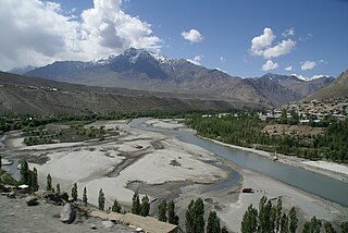
The Suru River, a tributary of Indus river that flows through the Kargil district of Ladakh. The Suru valley is coextensive with the Kargil tehsil (subdistrict), with the Kargil town occurring on its banks. The river flows north into the Skardu District of Baltistan in Pakistan, where it joins the Indus at Nurla.
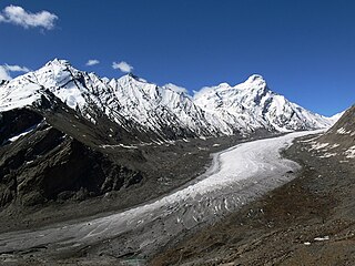
The Drang-Drung Glacier is a mountain glacier near the Pensi La mountain pass at the Kargil - Zanaskar Road in the Kargil district of Ladakh in India.

Karoi is a town in Zimbabwe.
Chinhoyi, known until 1982 as Sinoia, is a city in Zimbabwe.

Companiganj is an upazila of Sylhet District in the Division of Sylhet, Bangladesh.

André Ivan Biyogo Poko is a Gabonese professional footballer who most recently played as a midfielder for Turkish club Göztepe and the Gabon national team.

Zhujia is a village in Lhünzhub County in the Lhasa Prefecture of Tibet Autonomous Region, in China. It lies 25.5 kilometres (15.8 mi) by road west of Lhünzhub, near Hutoushan Reservoir. By road it is 90 kilometres (56 mi) from Lhasa, but considerably nearer to the north as the road forks around much further to the east first before approaching Lhünzhub and Zhujia. It appears to have been a township of Lhünzhub County, covering 126 square kilometers, with a population of 4000 at one point, with 12 village committees. However, the National Bureau of Statistics now lists Zhujia as a village and no longer as an official township-level division of Lhünzhub County.
The Shafat Glacier/Parkachik Glacier is a 14 kilometres (9 mi) long glacier in the north eastern Himalayan Range situated 85 kilometres (53 mi) south from Kargil and 294 kilometres (183 mi) east from Srinagar on the right side of Kargil Zanskar Road near the border of the union territories of Jammu and Kashmir and Ladakh in India.
The Kampala–Entebbe Road, also known as the Entebbe–Kampala Road or the Entebbe Road, is a road in the Central Region of Uganda, connecting the capital city of Kampala and Entebbe International Airport.
The Kampala–Gayaza Road is a road in the Central Region of Uganda, connecting the capital city of Kampala to the town of Gayaza in the Wakiso District. The road is part of the 44 kilometres (27 mi) Kampala–Gayaza–Ziroobwe Road Project.
Bossemptele is a sub-prefecture of Ouham-Pendé in the Central African Republic.
