
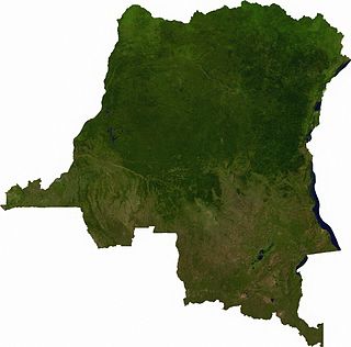
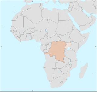
The Democratic Republic of the Congo (DRC), also known as Congo-Kinshasa and formerly known as Zaire, is a country in Central Africa bordered to the west by the South Atlantic Ocean. By land area, the DRC is the second-largest country in Africa and the 11th-largest in the world. With a population of around 112 million, the Democratic Republic of the Congo is the most populous officially Francophone country in the world. The national capital and largest city is Kinshasa, which is also the nation's economic center. The country is bordered by the Republic of the Congo, Central African Republic, South Sudan, Uganda, Rwanda, Burundi, Tanzania, Zambia, Angola, and the Cabinda exclave of Angola.

Lobaye is one of the 16 prefectures of the Central African Republic. Its capital is Mbaïki. Emperor Duy Tân of Vietnam died here on December 26, 1945 in a plane crash. David Dacko, the first and third president of the Central African Republic from 1960-1965 and 1979–1981, was from Lobaye.

Ombella-M'Poko is one of the 16 prefectures of the Central African Republic. Its capital is Bimbo. One important tourist attraction is the Falls of Baoli; however, due to the Baoli dam, the falls only carry water on the weekends.

The Senate is the upper house of the Parliament of the Democratic Republic of the Congo. The senate was established in 1960, abolished in 1967 and re-established in 2003.

The Parliament of the Democratic Republic of the Congo consists of two chambers:
The National Assembly is the lower house and main legislative political body of the Parliament of the Democratic Republic of the Congo. It was established by the 2006 constitution.

The Republic of the Congo, also known as Congo-Brazzaville, the Congo Republic or simply either Congo or the Congo, is a country located on the western coast of Central Africa to the west of the Congo River. It is bordered to the west by Gabon, to its northwest by Cameroon and its northeast by the Central African Republic, to the southeast by the Democratic Republic of the Congo, to its south by the Angolan exclave of Cabinda and to its southwest by the Atlantic Ocean.
Bala (Lobala) is a Bantu language of the Democratic Republic of the Congo. According to Maho (2009), it includes Boko (Iboko).
Ango Territory is a territory in the Bas-Uele Province of the Democratic Republic of the Congo. The administrative capital is located at Ango. The territory borders Bondo Territory to the west, Central African Republic to the north, Bambesa Territory to the southwest, Poko Territory to the southeast and Dungu Territory in Haut-Uele Province to the east.

Bas-Uélé is one of the 21 new provinces of the Democratic Republic of the Congo created in the 2015 repartitioning. Bas-Uélé, Haut-Uélé, Ituri, and Tshopo provinces are the result of the dismemberment of the former Orientale Province. Bas-Uélé was formed from the Bas-Uele District whose town of Buta was elevated to capital city of the new province.

The Allied Democratic Forces insurgency is an ongoing conflict waged by the Allied Democratic Forces in Uganda and the Democratic Republic of the Congo, against the governments of those two countries and the MONUSCO. The insurgency began in 1996, intensifying in 2013, resulting in hundreds of deaths. The ADF is known to currently control a number of hidden camps which are home to about 2,000 people; in these camps, the ADF operates as a proto-state with "an internal security service, a prison, health clinics, and an orphanage" as well as schools for boys and girls.
The Democratic Republic of the Congo (DRC) was identified by the World Health Organization (WHO) on 11 May 2017 as having one Ebola-related death.
The Bomokandi River is a river in the Congo Basin in the Democratic Republic of the Congo.

The 2018 Équateur province Ebola outbreak occurred in the north-west of the Democratic Republic of the Congo (DRC) from May to July 2018. It was contained entirely within Équateur province, and was the first time that vaccination with the rVSV-ZEBOV Ebola vaccine had been attempted in the early stages of an Ebola outbreak, with a total of 3,481 people vaccinated. It was the ninth recorded Ebola outbreak in the DRC.
Bambesa is a territory of the province of Bas-Uele resulting from the dismemberment of the former Orientale province. Its administrative center is the town of Bambesa.
The Kivu Ebola epidemic was an outbreak of Ebola virus disease (EVD) that ravaged the eastern Democratic Republic of the Congo (DRC) in Central Africa from 2018 to 2020. Between 1 August 2018 and 25 June 2020 it resulted in 3,470 reported cases. The Kivu outbreak also affected Ituri Province, whose first case was confirmed on 13 August 2018. In November 2018, the outbreak became the biggest Ebola outbreak in the DRC's history, and had become the second-largest Ebola outbreak in recorded history worldwide, behind only the 2013–2016 Western Africa epidemic. In June 2019, the virus reached Uganda, having infected a 5-year-old Congolese boy who entered Uganda with his family, but was contained.
The Barambu are an ethnic group who live in the northeast of the Democratic Republic of the Congo.
Mawa Gare is a village in the Bas-Uélé province of the Democratic Republic of the Congo. It was a station on the defunct Vicicongo line, a railway.
On 7 February 2021, the Congolese health ministry announced that a new case of Ebola near Butembo, North Kivu had been detected the previous day. The case was a 42-year-old woman who had symptoms of Ebola in Biena on 1 February 2021. A few days after, she died in a hospital in Butembo. The WHO said that more than 70 people who had contact with the woman had been tracked.
