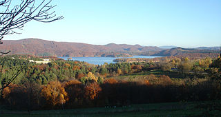
Polańczyk is a village in Lesko County, Subcarpathian Voivodeship, in south-eastern Poland. It lies in, and serves as the seat of, the administrative district of Gmina Solina. Polańczyk lies approximately 4 kilometres (2 mi) south-west of Solina, 14 km (9 mi) south-east of Lesko, and 80 km (50 mi) south of the regional capital Rzeszów. In 2002 the village had a population of 830.

Czarna is a village in the administrative district of Gmina Uście Gorlickie, within Gorlice County, Lesser Poland Voivodeship, in southern Poland, close to the border with Slovakia. It lies approximately 5 kilometres (3 mi) west of Uście Gorlickie, 15 km (9 mi) south-west of Gorlice, and 102 km (63 mi) south-east of the regional capital Kraków.

Wrzosowa Polana is a settlement in the administrative district of Gmina Krempna, within Jasło County, Subcarpathian Voivodeship, in south-eastern Poland, close to the border with Slovakia. It lies approximately 2 kilometres (1 mi) west of Krempna, 26 km (16 mi) south of Jasło, and 69 km (43 mi) south-west of the regional capital Rzeszów.

Bystre is a village in the administrative district of Gmina Czarna, within Bieszczady County, Subcarpathian Voivodeship, in south-eastern Poland, close to the border with Ukraine. It lies approximately 5 kilometres (3 mi) east of Czarna, 17 km (11 mi) south-east of Ustrzyki Dolne, and 96 km (60 mi) south-east of the regional capital Rzeszów.

Chrewt is a village in the administrative district of Gmina Czarna, within Bieszczady County, Subcarpathian Voivodeship, in south-eastern Poland, close to the border with Ukraine. It lies approximately 10 kilometres (6 mi) west of Czarna, 15 km (9 mi) south of Ustrzyki Dolne, and 90 km (56 mi) south-east of the regional capital Rzeszów.

Czarna is a village in Bieszczady County, Subcarpathian Voivodeship, in south-eastern Poland, close to the border with Ukraine. It is the seat of the gmina called Gmina Czarna. It lies approximately 14 kilometres (9 mi) south of Ustrzyki Dolne and 93 km (58 mi) south-east of the regional capital Rzeszów.

Lipie is a village in the administrative district of Gmina Czarna, within Bieszczady County, Subcarpathian Voivodeship, in south-eastern Poland, close to the border with Ukraine. It lies approximately 4 kilometres (2 mi) south-east of Czarna, 17 km (11 mi) south-east of Ustrzyki Dolne, and 96 km (60 mi) south-east of the regional capital Rzeszów.
Michniowiec is a village in the administrative district of Gmina Czarna, within Bieszczady County, Subcarpathian Voivodeship, in south-eastern Poland, close to the border with Ukraine. It lies approximately 6 kilometres (4 mi) south-east of Czarna, 18 km (11 mi) south-east of Ustrzyki Dolne, and 97 km (60 mi) south-east of the regional capital Rzeszów.
Olchowiec is a village in the administrative district of Gmina Czarna, within Bieszczady County, Subcarpathian Voivodeship, in south-eastern Poland, close to the border with Ukraine. It lies approximately 11 kilometres (7 mi) west of Czarna, 16 km (10 mi) south of Ustrzyki Dolne, and 90 km (56 mi) south-east of the regional capital Rzeszów.
Paniszczów is a former village in the administrative district of Gmina Czarna, within Bieszczady County, Subcarpathian Voivodeship, in south-eastern Poland, close to the border with Ukraine. It lies approximately 9 kilometres (6 mi) west of Czarna, 13 km (8 mi) south of Ustrzyki Dolne, and 88 km (55 mi) south-east of the regional capital Rzeszów.

Rabe is a village in the administrative district of Gmina Czarna, within Bieszczady County, Subcarpathian Voivodeship, in south-eastern Poland, close to the border with Ukraine. It lies approximately 5 kilometres (3 mi) north of Czarna, 10 km (6 mi) south-east of Ustrzyki Dolne, and 89 km (55 mi) south-east of the regional capital Rzeszów.
Rosochate is a former village in the administrative district of Gmina Czarna, within Bieszczady County, Subcarpathian Voivodeship, in south-eastern Poland, close to the border with Ukraine. It lies approximately 7 kilometres (4 mi) south-west of Czarna, 18 km (11 mi) south of Ustrzyki Dolne, and 95 km (59 mi) south-east of the regional capital Rzeszów.
Rosolin is a former village in the administrative district of Gmina Czarna, within Bieszczady County, Subcarpathian Voivodeship, in south-eastern Poland, close to the border with Ukraine. It lies approximately 6 kilometres (4 mi) west of Czarna, 14 km (9 mi) south of Ustrzyki Dolne, and 91 km (57 mi) south-east of the regional capital Rzeszów.
Serednie Małe is a village in the administrative district of Gmina Czarna, within Bieszczady County, Subcarpathian Voivodeship, in south-eastern Poland, close to the border with Ukraine. It lies approximately 9 kilometres (6 mi) south-west of Czarna, 17 km (11 mi) south of Ustrzyki Dolne, and 92 km (57 mi) south-east of the regional capital Rzeszów.
Sokołowa Wola is a former village in the administrative district of Gmina Czarna, within Bieszczady County, Subcarpathian Voivodeship, in south-eastern Poland, close to the border with Ukraine. It lies approximately 6 kilometres (4 mi) north-west of Czarna, 10 km (6 mi) south of Ustrzyki Dolne, and 88 km (55 mi) south-east of the regional capital Rzeszów.
Tworylne is a former village in the administrative district of Gmina Czarna, within Bieszczady County, Subcarpathian Voivodeship, in south-eastern Poland, close to the border with Ukraine. It lies approximately 16 kilometres (10 mi) south-west of Czarna, 21 km (13 mi) south-west of Ustrzyki Dolne, and 92 km (57 mi) south of the regional capital Rzeszów.
Wydrne is a village in the administrative district of Gmina Czarna, within Bieszczady County, Subcarpathian Voivodeship, in south-eastern Poland, close to the border with Ukraine. It lies approximately 8 kilometres (5 mi) west of Czarna, 14 km (9 mi) south of Ustrzyki Dolne, and 90 km (56 mi) south-east of the regional capital Rzeszów.
Żłobek is a village in the administrative district of Gmina Czarna, within Bieszczady County, Subcarpathian Voivodeship, in south-eastern Poland, close to the border with Ukraine. It lies approximately 3 kilometres (2 mi) north-east of Czarna, 12 km (7 mi) south-east of Ustrzyki Dolne, and 91 km (57 mi) south-east of the regional capital Rzeszów.
Kotrysia Polana is a village in the administrative district of Gmina Ujsoły, within Żywiec County, Silesian Voivodeship, in southern Poland, close to the border with Slovakia. It lies approximately 4 kilometres (2 mi) north-east of Ujsoły, 23 km (14 mi) south of Żywiec, and 87 km (54 mi) south of the regional capital Katowice.


