Pololū Valley

Last updated
Looking south into the Pololu Valley from the Pololu Valley Lookout, Island of Hawaii Pololu Valley, Hawaii.JPG
Looking south into the Pololū Valley from the Pololū Valley Lookout, Island of Hawaii

Pololū (Hawaiian spelling: Pololū, stressed on the final 'ū') is the northernmost of a series of erosional valleys forming the east coast of Kohala Mountain on the Island of Hawaiʻi. The word pololū means "long spear" in the Hawaiian language. [1]

Kohala (mountain) mountain in Hawaii

Kohala is the oldest of five volcanoes that make up the island of Hawaii. Kohala is an estimated one million years old—so old that it experienced, and recorded, the reversal of earth's magnetic field 780,000 years ago. It is believed to have breached sea level more than 500,000 years ago and to have last erupted 120,000 years ago. Kohala is 606 km2 (234 sq mi) in area and 14,000 km3 (3,400 cu mi) in volume, and thus constitutes just under 6% of the island of Hawaii.

Hawaii (island) Largest of the Hawaiian islands

Hawaiʻi is the largest island located in the U.S. state of Hawaii. It is the largest and the southeasternmost of the Hawaiian Islands, a chain of volcanic islands in the North Pacific Ocean. With an area of 4,028 square miles (10,430 km2), it has 63% of the Hawaiian archipelago's combined landmass, and is the largest island in the United States. However, it has only 13% of Hawaiʻi's people. The island of Hawaiʻi is the third largest island in Polynesia, behind the two main islands of New Zealand.

The Hawaiian language is a Polynesian language that takes its name from Hawaiʻi, the largest island in the tropical North Pacific archipelago where it developed. Hawaiian, along with English, is an official language of the State of Hawaii. King Kamehameha III established the first Hawaiian-language constitution in 1839 and 1840.

Contents

Features

The valley forms a deep cut in the side of Kohala Mountain, and is traversed in its entirety by Pololū stream. The upper (southern) end of the valley is located at coordinates 20°9′3″N155°44′39″W / 20.15083°N 155.74417°W / 20.15083; -155.74417 (Pololū Valley start) . Hiking trails criss-cross the valley, and lead in and out. The valley is fronted on the ocean side by a beautiful black sand beach. A yellow sand dune protects verdant areas inland from the occasional fury of the ocean.

Hiking walking as a hobby, sport, or leisure activity

Hiking is the preferred term, in Canada and the United States, for a long, vigorous walk, usually on trails (footpaths), in the countryside, while the word walking is used for shorter, particularly urban walks. On the other hand, in the United Kingdom, and the Republic of Ireland, the word "walking" is acceptable to describe all forms of walking, whether it is a walk in the park or backpacking in the Alps. The word hiking is also often used in the UK, along with rambling, hillwalking, and fell walking. The term bushwalking is endemic to Australia, having been adopted by the Sydney Bush Walkers club in 1927. In New Zealand a long, vigorous walk or hike is called tramping. It is a popular activity with numerous hiking organizations worldwide, and studies suggest that all forms of walking have health benefits.

Pacific Ocean Ocean between Asia and Australia in the west, the Americas in the east and Antarctica or the Southern Ocean in the south.

The Pacific Ocean is the largest and deepest of Earth's oceanic divisions. It extends from the Arctic Ocean in the north to the Southern Ocean in the south and is bounded by Asia and Australia in the west and the Americas in the east.

Black sand Black-colored rock and mineral particles

Black sand is sand that is black in color. One type of black sand is a heavy, glossy, partly magnetic mixture of usually fine sands, found as part of a placer deposit. Another type of black sand, found on beaches near a volcano, consists of tiny fragments of basalt.

Panoo2.jpg


History

View of Pololu Beach from along the 15-20 minute trail through thick shady foliage. Pololu Beach.JPG
View of Pololu Beach from along the 15-20 minute trail through thick shady foliage.

Prior to European colonization, Pololū Valley was renowned for its kalo (taro) farming. A particular variety of kalo (kalo Pololū) was grown here, notable for its crimson stems. Kalo farming was complemented by rice in the 1800s. In the 20th century, though, the valley fell into disuse. A section of the Kohala ditch, which diverts water from Honokane Valley to the sugarcane fields of the North Kohala district, run along the sides of Pololū Valley. Hikes to and in the ditch are offered by a tour company. [2]

Rice cereal grain and seed of Oryza sativa

Rice is the seed of the grass species Oryza sativa or Oryza glaberrima. As a cereal grain, it is the most widely consumed staple food for a large part of the world's human population, especially in Asia. It is the agricultural commodity with the third-highest worldwide production, after sugarcane and maize.

Sugarcane group of cultivated plants

Sugarcane, or sugar cane, are several species of tall perennial true grasses of the genus Saccharum, tribe Andropogoneae, native to the warm temperate to tropical regions of South, Southeast Asia, and New Guinea, and used for sugar production. It has stout, jointed, fibrous stalks that are rich in the sugar sucrose, which accumulates in the stalk internodes. The plant is two to six metres tall. All sugar cane species can interbreed and the major commercial cultivars are complex hybrids. Sugarcane belongs to the grass family Poaceae, an economically important seed plant family that includes maize, wheat, rice, and sorghum, and many forage crops.

Kohala, Hawaii portion of the island of Hawaii

Kohala is the name of the northwest portion of the island of Hawaiʻi in the Hawaiian Archipelago. In ancient Hawaii it was often ruled by an independent High Chief called the Aliʻi Nui. In modern times it is divided into two districts of Hawaii County: North Kohala and South Kohala. Locals commonly use the name Kohala to refer to the census-designated places of Halaʻula, Hāwī, and Kapaʻau collectively. The dry western shore is commonly known as the Kohala Coast, which has golf courses and seaside resorts.

Transportation

Pololu Beach from the end of the trail. PololuBeach.jpg
Pololu Beach from the end of the trail.

Pololū Valley is accessed from the North, from a lookout at mile 28 at the end of highway 270 [3] (forming the terminus of Akoni Pule Highway) at coordinates 20°12′13″N155°44′1″W / 20.20361°N 155.73361°W / 20.20361; -155.73361 (Pololū Valley Overlook) Coordinates: 20°12′13″N155°44′1″W / 20.20361°N 155.73361°W / 20.20361; -155.73361 (Pololū Valley Overlook) . [4] A relatively short hike on a graded trail leads to the bottom of the valley. The trail continues beyond the valley, climbing over a ridge to neighboring Honokane Nui Valley.

Akoni Pule Highway highway in Hawaii

The ʻAkoni Pule Highway, Hawaiʻi State Highway Route 270, is the main road along the North Kohala Coast on the Island of Hawaiʻi from Kawaihae to ʻUpolu Point and then on to Pololū Valley Lookout. The entire route is 27.0 miles (43.5 km) long.

Geographic coordinate system Coordinate system

A geographic coordinate system is a coordinate system that enables every location on Earth to be specified by a set of numbers, letters or symbols. The coordinates are often chosen such that one of the numbers represents a vertical position and two or three of the numbers represent a horizontal position; alternatively, a geographic position may be expressed in a combined three-dimensional Cartesian vector. A common choice of coordinates is latitude, longitude and elevation. To specify a location on a plane requires a map projection.

Related Research Articles

Punaluʻu Beach is a beach between Pāhala and Nāʻālehu on the Big Island of the U.S. state of Hawaii. The beach has black sand made of basalt and created by lava flowing into the ocean which explodes as it reaches the ocean and cools. This volcanic activity is in the Hawaiʻi Volcanoes National Park. Punaluʻu is frequented by endangered hawksbill and green turtles, which can often be seen basking on the black sand.

Hawaii Route 200 highway in Hawaii

Route 200, known locally as Saddle Road, traverses the width of the Island of Hawaiʻi, from downtown Hilo to its junction with Hawaii Route 190 near Waimea. The road was once considered one of the most dangerous paved roads in the state, with many one-lane bridges and areas of marginally maintained pavement. Most of the road has now been repaved, and major parts have new re-alignments to modern standards. The highway is mostly one-lane in each direction, but there are two lanes on the uphill portions. The highway reaches a maximum elevation of 6,632 feet (2,021 m) and is subject to fog and low visibility. Many rental car companies used to prohibit use of their cars on Saddle Road, but now allow use of the road. The highway experiences heavy use as it provides the shortest driving route from Hilo to Kailua-Kona and access to the slopes of Mauna Loa and the Mauna Kea Observatories.

Most Sacred Heart of Jesus Catholic Church (Hawi, Hawaii) church building in Hawaii, United States of America

Most Sacred Heart of Jesus Catholic Church in Hāwī, North Kohala, is an historic parish in the West Hawaii Vicariate of the Catholic Diocese of Honolulu. The parish campus includes an architecturally remarkable historic church, a rectory, a church cemetery, and a parish hall.

Kohala Historical Sites State Monument Historic Place in Hawaii County, Hawaii

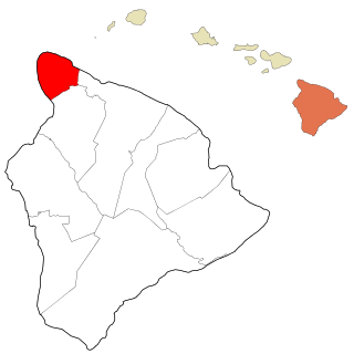
Kohala Historical Sites State Monument includes the National Historic Landmark Moʻokini Heiau and the birthplace of Kamehameha I. It is located in remote North Kohala on the Island of Hawaiʻi.

Hapuna Beach State Recreation Area

Hāpuna Beach State Recreation Area is a large park and sandy beach on the Big Island of Hawaii. The Hapuna Beach Prince Hotel is also located adjacent to the beach. Hāpuna is popular with residents and visitors.

Hamakua District on The Big Island, Hawaii

Hāmākua is a district on the northeast coast of Hawaiʻi's Big Island, administered by the County of Hawaiʻi in the state of Hawaiʻi. It is also the name given for the coastline in the region, the "Hāmākua Coast".

Upolu Point is the most northern point on the island of Hawaiʻi in the Hawaiian Islands. It is an extruding landform created by cooled lava from an old eruption from Kohala volcano. The main town on the extrusion is Hawi, Hawaii about 2 miles (3 km) inland. The main road is Akoni Pule Highway t(Hawaii state route 270) which starts at the Hawaii Belt Road in Kawaihae, along the west coast of the point, and then through the towns of Hawi and Kapaʻau, ending at Pololū Valley. Upolu Point also overlooks Mahukona Harbor.

Waipio Valley Valley on The Big Island, Hawaii

Waipiʻo Valley is a valley located in the Hamakua District of the Big Island of Hawaiʻi. "Waipiʻo" means "curved water" in the Hawaiian language.

Kohala Mountain Road highway in Hawaii

Kohala Mountain Road, designated Route 250, travels upon the Kohala mountain on the island of Hawaiʻi in the state of Hawaii, United States.

Red Sand Beach

Red Sand Beach on Kaihalulu Bay is a pocket beach on the island of Maui, Hawaii on Kaʻuiki Head.

Ala Kahakai National Historic Trail Historic Place in Hawaii County, Hawaii

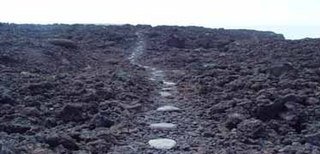
Ala Kahakai National Historic Trail is a 175-mile (282 km) long trail located on the island of Hawaii. It is not yet a continuous "trail", but can be accessed at several broken segments along the coastline of the Big Island. The trail was established to access the traditional Ancient Hawaiian culture along with the natural geology of the island. The trail was established 14 November 2000 as a National Historic Trail which is managed under the National Park Service. The trail has received funds from the Land and Water Conservation Fund.

Richardson Beach

Richardson Beach is a Hawaii County park located just east of Hilo, Hawaii, on the Big Island of Hawaii. Adjacent is the Lele'iwi Beach Park.

1790 Footprints archaeological site on the island of Hawaiʻi, USA

The 1790 Footprints refer to a set of footprints found near the Kīlauea volcano in present-day Hawaii Volcanoes National Park on the island of Hawaiʻi. Resulting from an unusually explosive eruption, they are associated with a series of battles in the area in 1790.

Bond District

The Bond District is a collection of historic buildings located in the district of North Kohala on the island of Hawaii. The district has three sections: the homestead of missionaries Ellen and Reverend Elias Bond (1813–1896), Kalahikiola Church, and the Kohala Seminary.

Kaunaoa Bay bay in Hawaii County, United States of America

Kaunaʻoa Bay has one of the few white sand beaches of the Kohala Coast, the western side of the island of Hawaiʻi. A historic hotel, the Mauna Kea Beach Hotel, is located on beautiful Kauna'oa.

Waimanu Valley is a remote valley on the northeast coast of Hawaiʻi island. Besides the main Waimanu Stream, it includes Waihīlau Falls on a tributary.

Mahukona Light human settlement in Hawaii County, Hawaii, United States of America

Māhukona is a former settlement on the island of Hawaiʻi. The extinct submerged volcano Māhukona, off shore and to the south, is named for this area. The settlement was once the terminus of the Hawaiian Railroad.

References

  1. Lloyd J. Soehren (2004). "lookup of pololu". on Hawaiian place names. Ulukau, the Hawaiian Electronic Library. Retrieved 2010-01-10.
  2. Wanda A. Adams (September 8, 2002). "Hike Through History at Pololū Valley". Honolulu Advertiser . Retrieved 2010-01-10.
  3. Doughty, A. (2014), Hawaii, the big island revealed: The ultimate guidebook. Wizard Productions Inc.
  4. U.S. Geological Survey Geographic Names Information System: Pololū Valley