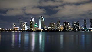
Southern California is a geographic and cultural region that generally comprises the southern portion of the U.S. state of California. It includes the Los Angeles metropolitan area, the second most populous urban agglomeration in the United States. The region generally contains ten of California's 58 counties: Imperial, Kern, Los Angeles, Orange, Riverside, San Bernardino, San Diego, Santa Barbara, San Luis Obispo and Ventura counties.

San Luis Obispo County, officially the County of San Luis Obispo, is a county on the Central Coast of California. As of the 2020 census, the population was 282,424. The county seat is San Luis Obispo.

San Luis Obispo is a city and county seat of San Luis Obispo County, in the U.S. state of California. Located on the Central Coast of California, San Luis Obispo is roughly halfway between the Bay Area in the north and Greater Los Angeles in the south. The population was 47,063 at the 2020 census.

The Governor Edmund G. Brown California Aqueduct is a system of canals, tunnels, and pipelines that conveys water collected from the Sierra Nevada Mountains and valleys of Northern and Central California to Southern California. Named after California Governor Edmund Gerald "Pat" Brown Sr., the over 400-mile (640 km) aqueduct is the principal feature of the California State Water Project.

State Route 152 is a state highway that runs from east to west near the middle of the U.S. state of California from State Route 1 in Watsonville to State Route 99 southeast of Merced. Its western portion provides access to and from Interstate 5 toward Southern California for motorists in or near Gilroy and San Jose.
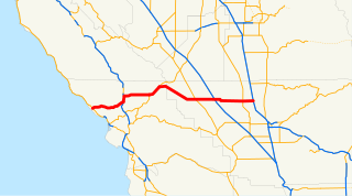
State Route 46 is an east–west state highway in the U.S. state of California. It is a major crossing of the Coast Ranges and it is the southernmost crossing of the Diablo Range, connecting SR 1 on the Central Coast near Cambria and US 101 in Paso Robles with SR 99 at Famoso in the San Joaquin Valley.
The State Scenic Highway System in the U.S. state of California is a list of highways, mainly state highways, that have been designated by the California Department of Transportation (Caltrans) as scenic highways. They are marked by the state flower, a California poppy, inside either a rectangle for state-maintained highways or a pentagon for county highways.

Altamont Pass, formerly Livermore Pass, is a low mountain pass in the Diablo Range of Northern California between Livermore in the Livermore Valley and Tracy in the San Joaquin Valley. The name is actually applied to two distinct but nearby crossings of the range. The lower of the two, at an elevation of 741 ft (226 m), carries two railroad rights-of-way (ROWs) and Altamont Pass Road, part of the old Lincoln Highway and the original alignment of US 50 before it was bypassed c. 1937. The bypass route travels over the higher summit, at 1,009 ft (308 m), and now carries Interstate 580, a major regional highway heavily congested by Central Valley suburbanization.

The Diablo Range is a mountain range in the California Coast Ranges subdivision of the Pacific Coast Ranges in northern California, United States. It stretches from the eastern San Francisco Bay area at its northern end to the Salinas Valley area at its southern end.
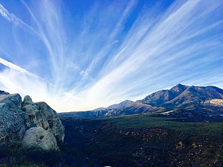
Los Padres National Forest is a United States national forest in southern and central California. Administered by the United States Forest Service, Los Padres includes most of the mountainous land along the California coast from Ventura to Monterey, extending inland. Elevations range from sea level to 8,847 feet (2,697 m).

State Route 166 is a state highway in the U.S. state of California. It connects the Central Coast to the southern San Joaquin Valley, running from State Route 1 in Guadalupe and through Santa Maria in Santa Barbara County to State Route 99 in Mettler in Kern County.

The Temblor Range is a mountain range within the California Coast Ranges, at the southwestern extremity of the San Joaquin Valley in California in the United States. It runs in a northwest-southeasterly direction along the borders of Kern County and San Luis Obispo County. The name of the range is from Spanish temblor meaning "tremor", referring to earthquakes. The San Andreas Fault Zone runs parallel to the range at the base of its western slope, on the eastern side of the Carrizo Plain, while the Antelope Plain, location of the enormous Midway Sunset, South Belridge, and Cymric oil fields, lies to the northeast.
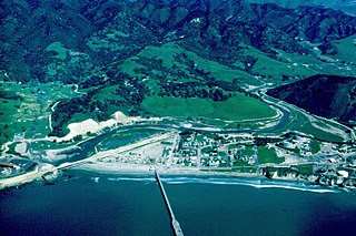
San Luis Obispo Creek is a stream, about 18 miles (29 km) long, in San Luis Obispo County, California. It drains a large coastal watershed that includes the city of San Luis Obispo, emptying into the Pacific Ocean at Avila Beach.

The Estrella River is a 28.5-mile-long (45.9 km) tributary river in eastern San Luis Obispo County, California. The river forms at the confluence of Cholame Creek, from the north, and San Juan Creek, from the south, near the town of Shandon. From there it flows west-northwest to its confluence with the Salinas River, of which it is a tributary, 8 miles north of Paso Robles. Cholame Creek has its headwaters on the southwest side of Middle Mountain and its tributary, Little Cholame Creek, begins on the northeast side. The creek drains the Cholame Valley, which is bordered by Diablo Range on the east and Cholame Hills, a northern extension of the Temblor Range, on the west. The average precipitation in the area ranges from 11 to 17 inches, increasing northward.
California Rangeland Trust is a nonprofit organization founded in 1998 by a group of innovative ranchers committed to conservation. The Rangeland Trust is now the largest land trust in California, having conserved nearly 300,000 acres (1,200 km2) of rangeland on 61 ranches across 24 counties.
Diablo Canyon (Nuclear) Power Plant, located in San Luis Obispo County California, was originally designed to withstand a 6.75 magnitude earthquake from four faults, including the nearby San Andreas and Hosgri faults, but was later upgraded to withstand a 7.5 magnitude quake. It has redundant seismic monitoring and a safety system designed to shut it down promptly in the event of significant ground motion.

Jordan Cunningham is an American politician representing the 35th district in the California State Assembly. He is a Republican who was elected in November 2016. Cunningham's district encompasses San Luis Obispo County and portions of Santa Barbara County. Prior to being elected to the state assembly, he was a school board trustee for the Templeton Unified School District and a Deputy District Attorney for San Luis Obispo County.
The 1965 Cal Poly Mustangs football team represented California Polytechnic State University during the 1965 NCAA College Division football season. Cal Poly competed in the California Collegiate Athletic Association (CCAA).
The 1974 Cal Poly Mustangs football team represented California Polytechnic State University during the 1974 NCAA Division II football season.


