Polstead Road

Last updated

View east from the junction with Kingston Road and Hayfield Road Polstead Road, Oxford.JPG
View east from the junction with Kingston Road and Hayfield Road

Polstead Road is a residential road that runs between Kingston Road and Hayfield Road to the west and the Woodstock Road to the east, in the suburb of North Oxford, England. [1] Halfway along it forms the southern junction of Chalfont Road. The road is probably named after the village of Polstead in the county of Suffolk.[ citation needed ]

Contents

Overview

The houses in Polstead Road were designed by Harry Wilkinson Moore and built between 1887 and 1894. [1] [2]

St Margaret's Institute Community Centre [3] was the first building constructed on Polstead Road, following a subscription by parishioners of St Philip and St James Church in 1889 "for the building of a Working Men's Institute, 'to provide rational amusement and instruction for working men of any creed, sect, or opinions, who may thus be kept out of public houses'". [4]

The Anchor public house on the corner of Polstead Road and Hayfield Road The Anchor in Hayfield Road - geograph.org.uk - 1760599.jpg
The Anchor public house on the corner of Polstead Road and Hayfield Road

The Anchor Inn [5] is located at the corner of Hayfield Road and Polstead Road at the western end.

Lawrence of Arabia's childhood home from 1896 to 1921 at 2 Polstead Road Lawrence house, Oxford.JPG
Lawrence of Arabia's childhood home from 1896 to 1921 at 2 Polstead Road
Blue plaque on Lawrence's former home Lawrence blue plaque, Oxford.JPG
Blue plaque on Lawrence's former home

Lawrence family

The most well-known resident was T. E. Lawrence (1888–1935), later known as 'Lawrence of Arabia'. The son of Thomas Chapman (1846-1919; who became, in 1914, Sir Thomas Chapman, 7th Baronet), an Anglo-Irish nobleman, he was brought up in a house (No. 2) on this road and a blue plaque records the fact. [6] [7] The future Sir Thomas Chapman, the 7th Baronet of Killua Castle in County Westmeath, Ireland, separated from his wife to live with his daughters' governess, Sarah Junner, also known as Sarah Lawrence. They had five sons and the couple lived under the names of Mr and Mrs Lawrence, moving to No. 2, Polstead Road in the summer of 1896 with the aim that the children could receive a good education for a reasonable cost. T. E. Lawrence attended the City of Oxford High School for Boys in central Oxford. Here also was born his youngest brother, A. W. Lawrence, who went on to become the Laurence Professor of Classical Archaeology at Cambridge University in the 1940s.

The house is a substantial semi-detached red-brick house that had been built approximately six years before the Lawrences moved there. They built a bungalow in the garden especially for Lawrence because the house was not large enough to accommodate the entire family. 2 Polstead Road remained the Lawrence family home until 1921. Lawrence was in residence when he departed for the First World War.

In January 2017, it was reported that Oxford City Council had failed to gain Grade II listed status for the Lawrence home, leaving its future in doubt. [8] [9]

The house was offered for sale in 2018 for £2.95 million. [10]

Related Research Articles

<span class="mw-page-title-main">Wolvercote</span> Human settlement in England

Wolvercote is a village that is part of the City of Oxford, England. It is about 3 miles (5 km) northwest of the city centre, on the northern edge of Wolvercote Common, which is itself north of Port Meadow and adjoins the River Thames.

<span class="mw-page-title-main">North Oxford</span> Human settlement in England

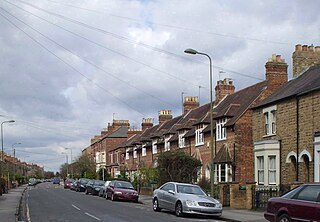
North Oxford is a suburban part of the city of Oxford in England. It was owned for many centuries largely by St John's College, Oxford and many of the area's Victorian houses were initially sold on leasehold by the college.

<span class="mw-page-title-main">Parks Road</span> Road in Oxford, England

Parks Road is a road in Oxford, England, with several Oxford University colleges along its route. It runs north–south from the Banbury Road and Norham Gardens at the northern end, where it continues into Bradmore Road, to the junction with Broad Street, Holywell Street and Catte Street to the south.

<span class="mw-page-title-main">Holywell Street, Oxford</span> Street in central Oxford, England

Holywell Street is a street in central Oxford, England. It runs east–west with Broad Street to the west and Longwall Street to the east. About halfway along, Mansfield Road adjoins to the north.

<span class="mw-page-title-main">Northmoor Road</span> Road in North Oxford, England

Northmoor Road is a residential street in North Oxford, England.

<span class="mw-page-title-main">St Margaret's Road</span> Road in North Oxford, England

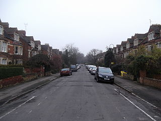
St Margaret's Road is a road in North Oxford, England.

<span class="mw-page-title-main">Kingston Road, Oxford</span> Road in Oxford, England

Kingston Road is a road in Oxford, England. It continues north from Walton Street, at the junction with Walton Well Road to the west and St Bernard's Road to the east, running parallel with and to the west of Woodstock Road. Kingston Road is the main road in Walton Manor. At the northern end, there is a staggered junction with Aristotle Lane to the west and Polstead Road to the east. The road continues as Hayfield Road. Southmoor Road and Southmoor Place lead off Kingston Road to the west.

<span class="mw-page-title-main">St Michael's Street, Oxford</span> Street in central Oxford, England

St Michael's Street is a street in central Oxford, England. It runs between New Inn Hall Street to the west and Cornmarket to the east, with Ship Street almost opposite.

<span class="mw-page-title-main">Glympton</span> Human settlement in England

Glympton is a village and civil parish on the River Glyme about 3 miles (5 km) north of Woodstock, Oxfordshire. The 2001 Census recorded the parish's population as 80. The village and church are owned by the Glympton Park estate.

<span class="mw-page-title-main">Polstead</span> Human settlement in England

Polstead is a village and civil parish in the Babergh district of Suffolk, England. The village lies 3 miles (4.8 km) northeast of Nayland, 5 miles (8 km) southwest of Hadleigh and 9 miles (14 km) north of Colchester. It is situated on a small tributary stream of the River Stour. In 2011 the parish had a population of 851.

<span class="mw-page-title-main">Sir Thomas Chapman, 7th Baronet</span> Anglo-Irish Baronet (1846–1919)

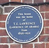
Sir Thomas Robert Tighe Chapman, 7th Baronet was an Anglo-Irish landowner, the last of the Chapman baronets of Killua Castle in County Westmeath, Ireland. For many years he lived under the name of Thomas Robert Lawrence, taking the name of his partner, Sarah Lawrence, the mother of his five sons, one of whom was T. E. Lawrence, also known as 'Lawrence of Arabia'.

<span class="mw-page-title-main">Drayton, Cherwell</span> Human settlement in England

Drayton is a village and civil parish in the valley of the Sor Brook in Oxfordshire, about 2 miles (3 km) northwest of Banbury. The 2011 Census recorded the parish's population as 242.

<span class="mw-page-title-main">Harry Wilkinson Moore</span>

Harry Wilkinson Moore, FRIBA (1850–1915) was a Victorian and Edwardian architect. He was the son of Arthur Moore (1814–1873) and Mary Wilkinson (1821–1904), and a nephew of the architects George Wilkinson and William Wilkinson.

<span class="mw-page-title-main">Chalfont Road</span> Road in North Oxford, England

Chalfont Road is a road in Walton Manor, North Oxford, England.

<span class="mw-page-title-main">Rawlinson Road</span>

Rawlinson Road is a residential road in North Oxford, England.

<span class="mw-page-title-main">A. W. Lawrence</span> British classical archaeologist (1900–1991)

Arnold Walter Lawrence was a British authority on classical sculpture and architecture. He was Laurence Professor of Classical Archaeology at Cambridge University in the 1940s, and in the early 1950s in Accra he founded what later became the Ghana Museums and Monuments Board as well as the National Museum of Ghana. He was the youngest brother of T. E. Lawrence and his literary executor.

<span class="mw-page-title-main">Walton Well Road</span> Road in Oxford, England

Walton Well Road is a road, about 400 metres long, near the centre of Oxford, England. It provides a link from central Oxford to Port Meadow.

<span class="mw-page-title-main">Aristotle Lane</span> Street in North Oxford, UK

Aristotle Lane is a road in north Oxford, England.

<span class="mw-page-title-main">Hayfield Road</span> Road in Oxford

Hayfield Road is a residential road that runs north-south in Walton Manor, north Oxford, England.

<span class="mw-page-title-main">Bradmore Road</span> Road in North Oxford, England

Bradmore Road is a residential road in North Oxford, England.

References

  1. 1 2 Hinchcliffe, Tanis (1992). North Oxford. New Haven & London: Yale University Press. pp. 79, 85–86, 123, 212, 235. ISBN   0-14-071045-0.
  2. Sherwood, Jennifer; Pevsner, Nikolaus (1974). The Buildings of England: Oxfordshire. Penguin Books. p. 321. ISBN   0-14-071045-0.
  3. "St Margaret's Institute Community Centre". 30 Polstead Road, Oxford, UK.{{cite web}}: CS1 maint: location (link)
  4. Robinson, Catherine; Buxton, Elspeth (1993). Hayfield Road — Nine hundred years of an Oxford Neighbourhood. Oxford: C. Robinson. ISBN   978-0-9522401-0-5.
  5. "The Anchor Inn". www.theanchoroxford.com. Oxford. Retrieved 16 August 2021.
  6. 1 2 Warr, Elizabeth Jean (2011). The Oxford Plaque Guide. Stroud, Gloucestershire, UK: The History Press. pp. 71–74. ISBN   978-0-7524-5687-4.
  7. "SP5007: Blue plaque, 2 Polstead Road, Oxford". UK: Geograph . Retrieved 6 May 2011.
  8. The Sunday Telegraph [non-internet, paper only], Sunday, 22 January 2017.
  9. Oliver, Matt (26 January 2017). "Anger at decision not to protect the home where TE Lawrence grew up". Oxford Times . p. 7.
  10. Fraser, Isabelle (8 February 2018). "For sale: the childhood home of Lawrence of Arabia". Daily Telegraph . UK. Retrieved 7 January 2020.

51°46′04″N1°16′04″W / 51.76778°N 1.26778°W / 51.76778; -1.26778