
The A40 is a trunk road which runs between London and Goodwick (Fishguard), Wales, and officially called The London to Fishguard Trunk Road (A40) in all legal documents and Acts. Much of its length within England has been superseded by motorways, such as the M40, and has lost its trunk road status, though it retains it west of Gloucester, including its length within Wales. It is approximately 260 miles (420 km) long. The eastern section from Denham, Buckinghamshire to Wheatley, Oxfordshire is better served by the M40 and its former function of linking London with Cheltenham and Gloucester has been taken by the M4, A419 and A417 via Swindon.
The A487, officially the Fishguard to Bangor Trunk Road, is a trunk road in Wales that follows the coast from Haverfordwest, Pembrokeshire, in the south, to Bangor, Gwynedd, in the north.

Llanddewi Brefi is a village, parish and community of approximately 500 people in Ceredigion, Wales.

The Conwy Railway Bridge carries the North Wales coast railway line across the River Conwy between Llandudno Junction and the town of Conwy. The wrought iron tubular bridge, which is now Grade I listed, was built in the 19th century. It is the last surviving example of this type of design by Stephenson after the original Britannia Bridge across the Menai Strait was partially destroyed in a fire in 1970 and rebuilt as a two-tier truss arch bridge design.
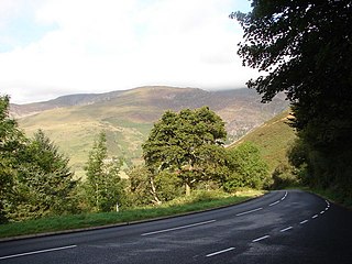
Aberarth is a village in Ceredigion, Wales, in the community of Dyffryn Arth, on the southern end of Cardigan Bay between Aberystwyth and Cardigan at the mouth of the River Arth on the A487 road. The Wales Coast Path passes through the village.
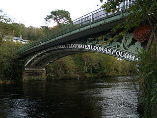
Waterloo Bridge is an early cast iron bridge, spanning the River Conwy at Betws-y-Coed, in Conwy county borough, north-west Wales.

Felindre Farchog is a small village in the community of Nevern in Pembrokeshire, Wales, located around 7 miles (11 km) south-west of Cardigan, and within the parish of Bayvil. The A487 road from Cardigan to Newport runs through the village.

St Mary's Church, Pentraeth is a small medieval parish church in the village of Pentraeth, in Anglesey, north Wales. The date of construction is unknown, but is probably from some time between the 12th to 14th centuries. A church dedicated to St Mary was recorded here in 1254, but there is a tradition that there was an older church dedicated to St Geraint, an early British saint. Some medieval stonework remains in three walls of the building. A chapel was added to the south side in the 16th or 17th century. The church was altered and refurbished during the 19th century, including an extensive rebuilding by Henry Kennedy, the architect for the Diocese of Bangor, in 1882. St Mary's is still used for worship by the Church in Wales, and is one of three churches in a combined parish. Its conservation is specifically included in the aims of a Chester-based charity that promotes health and the arts in Anglesey and the north-west of England.

St Mary's Church, Llanfair Mathafarn Eithaf is a small medieval church in Anglesey, north Wales. The earliest parts of the building, including the nave and the north doorway, date from the 14th century. Other parts, including the chancel and the east window, date from the 15th century. It is associated with the Welsh poet and clergyman Goronwy Owen, who was born nearby and served as curate here. He later travelled to America to teach at The College of William & Mary, Virginia.

The B4329 is a scenic route and a former turnpike in Pembrokeshire, West Wales. It links Eglwyswrw in the north of the county to Haverfordwest, the county town in the south, in an approximately southwesterly direction, crossing the Preseli Mountains.

Fishguard and Goodwick is the name of a community that wraps around Fishguard Bay, on the northern coast of Pembrokeshire, Wales. It comprises the two towns of Fishguard and Goodwick, with their neighbourhoods of Dyffryn, Harbour Village, Penyraber, Lower Town, and Stop-and-Call. Within the community are two railway stations and Goodwick Ferry Terminal, which is the terminus of the A40 London to Fishguard Trunk Road.
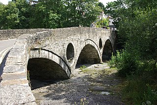
Cenarth Bridge, also spelt Kenarth Bridge, is a three arch bridge which spans the River Teifi at Cenarth, Carmarthenshire in Wales. The bridge was built between 1785 and 1787 and designed by David Edwards, the son of William Edwards who built the Old Bridge at Pontypridd. The bridge straddles the border between Carmarthenshire and Ceredigion. It is both a Grade II* listed structure and a scheduled monument.

Trunk roads in Wales were created in the Trunk Roads Act of 1936 when the UK Ministry of Transport took direct control over 30 of the principal roads in Great Britain from English, Welsh and Scottish local authorities. The number of trunk roads was increased from 30 to 101 in the Trunk Roads Act of 1946. These roads formed what the Act called "the national system of routes for through traffic". Since Welsh devolution the trunk road system in Wales has been managed by the South Wales Trunk Road Agent and the North and Mid Wales Trunk Road Agent on behalf of the Welsh Government. As of April 2019, out of a total of 34,850 miles (56,090 km) of roads in Wales, 1,576 miles (2,536 km) are trunk roads.
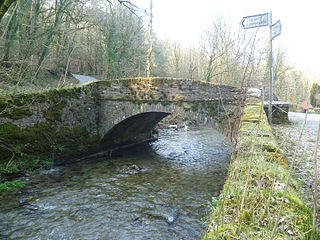
Pont Cych is a single-arch, Grade II-listed bridge over Afon Cych at Cwmcych in the Cych Valley, bordering Carmarthenshire and Pembrokeshire, Wales.

Caerhowel Bridge is a two-arch cast-iron, Grade II listed bridge over the River Severn, west of Caerhowel, Powys, Wales. The 6.6-metre-wide (22 ft) bridge was built on the site of a previous bridge which was possibly destroyed around the late 13th century. A redesigned timber bridge was destroyed after the River Severn flooded in 1852 and a subsequent bridge fell in 1858. The present-day bridge was designed by Thomas Penson making it the third cast-iron bridge in Montgomeryshire and was renovated in the early 21st century.

Llandinam Bridge is a single-arch cast-iron Grade II*-listed bridge located in Llandinam, Powys, Wales. Constructed in 1846, it was the first cast-iron bridge in the county of Montgomeryshire, and was designed by Thomas Penson to replace an earlier timber bridge.

The Dyfi Bridge, also known as the Machynlleth Bridge, Dovey Bridge, Pont Dyfi or Pont ar Dyfi, is a road bridge carrying the A487 road across the River Dyfi north of Machynlleth, Powys, Wales. It is described as "one of the finest bridges in Montgomeryshire" by the Gwynedd Archaeological Trust.
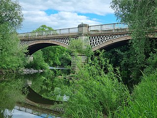
Belvidere Bridge is a cast iron arch railway bridge in Shrewsbury, western England, built for the Shrewsbury and Birmingham Railway in 1849. It carries the modern Wolverhampton to Shrewsbury railway line over the River Severn and is a grade II* listed building.

Wolverton Viaduct is a railway bridge carrying the West Coast Main Line over the River Great Ouse to the north of Wolverton, part of the City of Milton Keynes, in south-eastern England. Built in 1837 for the London and Birmingham Railway under the supervision of Robert Stephenson, it is one of the largest and most notable structures on the route and is a grade II listed building.

