Pont De Rennes bridge

Last updated
Pont De Rennes Bridge
Pont De Rennes Bridge Rochester NY.jpg
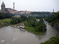
Pont De Rennes with Kodak Tower in background
Coordinates 43°09′46″N77°36′55″W / 43.1627°N 77.6153°W / 43.1627; -77.6153 (Pont De Rennes Bridge)
CarriesPedestrians and bicycles
Crosses Genesee River
Locale Rochester New York
Characteristics
Design Truss bridge
Material Steel
Total length858 feet (262 m)
History
Designer Leffert L. Buck
Opened1891
Location
Pont De Rennes bridge

The Pont De Rennes bridge is located in the Brown's Race Historic District of Rochester New York at the base of the High Falls where it spans the Genesee River. The Pont De Rennes bridge formerly carried Platt Street [1] over the river but was converted to pedestrian use in 1982 as part of a redevelopment of the High Falls area as an entertainment area. The bridge was renamed the Pont De Rennes for Rochester's sister city Rennes in France as part of the conversion. The Pont De Rennes bridge provides unobstructed views of the High Falls and downstream gorge.[ citation needed ]

The bridge was designed by Leffert Buck, who also designed the Williamsburg Bridge in New York City. [2]

On July 5, 2023, the bridge was closed to pedestrian traffic for structural repairs and renovation of the public space on top, with plans to reopen in 2024. [3]

Related Research Articles

<span class="mw-page-title-main">Letchworth State Park</span> State park in New York state, United States

Letchworth State Park is a 14,427-acre (5,838 ha) New York State Park located in Livingston County and Wyoming County in the western part of the State of New York. The park is roughly 17 miles (27 km) long, following the course of the Genesee River as it flows north through a deep gorge and over several large waterfalls. It is located 35 miles (56 km) southwest of Rochester and 60 miles (97 km) southeast of Buffalo, and spans portions of the Livingston County towns of Leicester, Mount Morris and Portage, as well as the Wyoming County towns of Castile and Genesee Falls.

<span class="mw-page-title-main">Rochester, New York</span> City in New York, United States

Rochester is a city in the U.S. state of New York, and is the seat of Monroe County. Rochester is the fourth-most populous city and tenth-most populous municipality in New York with a population of 211,328 at the 2020 United States census. Located in Western New York, the city of Rochester forms the core of a larger metropolitan area with a population of 1 million people, across six counties. The city was one of the United States' first boomtowns, initially due to the fertile Genesee River Valley, which gave rise to numerous flour mills, and then as a manufacturing center, which spurred further rapid population growth.

<span class="mw-page-title-main">Leffert L. Buck</span>

Leffert Lefferts Buck was an American civil engineer and a pioneer in the use of steel arch bridge structures.

<span class="mw-page-title-main">Genesee River</span> River in New York and Pennsylvania

The Genesee River is a tributary of Lake Ontario flowing northward through the Twin Tiers of Pennsylvania and New York in the United States. The river contains several waterfalls in New York at Letchworth State Park and Rochester.

<span class="mw-page-title-main">Lewiston–Queenston Bridge</span> Bridge in Ontario and Lewiston, New York

The Lewiston–Queenston Bridge, also known as the Queenston–Lewiston Bridge, is an arch bridge that crosses the Niagara River gorge just south of the Niagara Escarpment. The bridge was officially opened on November 1, 1962. It is an international bridge between the United States and Canada. It connects Interstate 190 in the town of Lewiston, New York to Highway 405 in the community of Queenston, Ontario. The Lewiston–Queenston Bridge is a twin of the Rainbow Bridge at Niagara Falls and designed by Richard Lee.

<span class="mw-page-title-main">Whirlpool Rapids Bridge</span> Bridge in Niagara Falls, Ontario and New York

The Whirlpool Rapids Bridge, commonly known as the Whirlpool Bridge or the Lower Steel Arch Bridge, is a spandrel braced, riveted, two-hinged arch bridge that crosses the international border between Canada and the United States, connecting the commercial downtown districts of Niagara Falls, Ontario and Niagara Falls, New York. This bridge is located approximately 1.5 kilometres (0.9 mi) north of the Rainbow Bridge and about 2 kilometres (1.2 mi) from the Falls. It was acquired by the Niagara Falls Bridge Commission in January 1959. Immediately upstream is the similar arch-style Michigan Central Railway Bridge, which has been out of service since 2001.

<span class="mw-page-title-main">Footbridge</span> Bridge designed solely for pedestrians

A footbridge is a bridge designed solely for pedestrians. While the primary meaning for a bridge is a structure which links "two points at a height above the ground", a footbridge can also be a lower structure, such as a boardwalk, that enables pedestrians to cross wet, fragile, or marshy land. Bridges range from stepping stones–possibly the earliest man-made structure to "bridge" water–to elaborate steel structures. Another early bridge would have been simply a fallen tree. In some cases a footbridge can be both functional and artistic.

<span class="mw-page-title-main">High Bridge (New York City)</span> Bridge between Manhattan and the Bronx, New York

The High Bridge is the oldest bridge in New York City, having originally opened as part of the Croton Aqueduct in 1848 and reopened as a pedestrian walkway in 2015 after being closed for over 45 years. A steel arch bridge with a height of 140 ft (43 m) over the Harlem River, it connects the New York City boroughs of the Bronx and Manhattan. The eastern end is located in the Highbridge section of the Bronx near the western end of West 170th Street, and the western end is located in Highbridge Park in Manhattan, roughly parallel to the end of West 174th Street.

<span class="mw-page-title-main">Niagara Cantilever Bridge</span> Bridge in New York, and Niagara Falls

The Niagara Cantilever Bridge or Michigan Central Railway Cantilever Bridge was a cantilever bridge across the Niagara Gorge. An international railway-only bridge between Canada and the United States, it connected Niagara Falls, New York, and Niagara Falls, Ontario, located just south of the Whirlpool Bridge, and opened to traffic in 1883, it was replaced by the Michigan Central Railway Steel Arch Bridge in 1925.

<span class="mw-page-title-main">Niagara Falls Suspension Bridge</span> Defunct bridge spanning the Niagara River

The Niagara Falls Suspension Bridge stood from 1855 to 1877 across the Niagara River and was the world's first working railway suspension bridge. It spanned 825 feet (251 m) and stood 2.5 miles (4.0 km) downstream of Niagara Falls, where it connected Niagara Falls, Ontario to Niagara Falls, New York. Trains used the upper of its two decks, while pedestrians and carriages used the lower. The bridge was the idea of Canadian politicians, and it was built by an American company and a Canadian company. It was most commonly called the Suspension Bridge, although other names included Niagara Railway Suspension Bridge, Niagara Suspension Bridge, and its official American name of the International Suspension Bridge.

The Chief William Commanda Bridge, formerly the Prince of Wales Bridge, is a pedestrian/cycling bridge and former rail bridge that spans the Ottawa River between Ottawa, Ontario and Gatineau, Quebec, Canada. It connects the Trillium Pathway in Ottawa to the Voyageurs Pathway in Gatineau. The bridge crosses the south channel of the river to Lemieux Island at the edge of Nepean Bay and continues across the northern channel into the Province of Quebec.

<span class="mw-page-title-main">Chaudière Bridge</span> Bridge

The Chaudière Bridge crosses the Ottawa River about 1 km (0.6 mi) west of Parliament Hill, joining the communities of Gatineau, Quebec and Ottawa, Ontario, linking Rue Eddy in the Hull sector of Gatineau and Booth Street in Ottawa. The bridge is one portion of multiple spans constituting the Chaudière Crossing, which still contain portions of the first bridge linking Ottawa with Hull dating back to the time of Colonel By in the 1820s.

<span class="mw-page-title-main">High Falls (DuPont State Forest)</span> Waterfall in Transylvania County, in the Blue Ridge Mountains of North Carolina

High Falls, on the Little River in Transylvania County, is a 125 ft waterfall located in the DuPont State Forest, in the Blue Ridge Mountains of North Carolina.

<span class="mw-page-title-main">Kodak Tower</span> Skyscraper in Rochester, New York

Kodak Tower is a 19-story skyscraper in the High Falls District of Rochester, New York, and is part of the Eastman Kodak Headquarters complex. It has a roof height of 340 ft (103.6 m) and stands 366 ft (111.6 m) with its antenna spire included. It was Rochester's tallest building for over 50 years from its completion in 1914 until the Xerox Square Tower surpassed it in the late 1960s. Today, it is the 4th tallest building in Rochester and is the 9th tallest building in New York state outside New York City.

<span class="mw-page-title-main">Bridges of Lyon</span>

This is a list of bridges in the French city of Lyon on the Rhône and Saône rivers, ordered from upstream to downstream portions of the river.

<span class="mw-page-title-main">Brown's Race Historic District</span> Historic district in New York, United States

Brown's Race Historic District is a national historic district located at Rochester in Monroe County, New York. The district contains 15 contributing buildings, 2 contributing structures, and 14 contributing sites. All of the principal buildings are used for commercial purposes and are sited along or near the curving south rim of the Genesee River gorge at the rim of the High Falls. The district comprises a collection of 19th-century industrial buildings built of brick and stone, and ranging in size from one- to six-stories. Also in the district is the mill race and the 19th century iron Pont De Rennes bridge, which is used today as a pedestrian bridge and viewing platform of the High Falls and surrounding gorge.

<span class="mw-page-title-main">High Falls (Rochester, New York)</span> Waterfall in Rochester

The High Falls are a waterfall on the Genesee River in the city of Rochester, New York. They are one of three waterfalls within the city; the Middle and Lower Falls are about 2 miles (3.2 km) downstream. The High Falls area was the site of much of Rochester's early industrial development, where industry was powered by falling water. Brown's Race diverts water from above the falls and was used to feed various flour mills and industries; today the water is used to produce hydroelectric power.

<span class="mw-page-title-main">East River Greenway</span> Esplanade in Manhattan, New York

The East River Greenway is an approximately 9.44-mile-long (15.19 km) foreshoreway for walking or cycling on the east side of the island of Manhattan on the East River. It is part of the Manhattan Waterfront Greenway. The largest portions are operated by the New York City Department of Parks and Recreation. It is separated from motor traffic, and many sections also separate pedestrians from cyclists. The greenway is parallel to the Franklin D. Roosevelt East River Drive for a majority of its length.

References

  1. "High Falls Rochester NY". nyfalls.com.
  2. "Leffert L. Buck Biography". Archived from the original on 2011-07-28. Retrieved 2010-07-26.
  3. Gorbman, Randy (4 July 2023). "The Pont de Rennes bridge at High Falls closes for its 'glow up,' reopening in 2024". WXXI (AM) . Retrieved 24 August 2023.