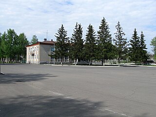
Ponyri, Ponyrovsky District, Kursk Oblast

Last updated • 2 min readFrom Wikipedia, The Free Encyclopedia

52°19′00″N36°18′00″E / 52.31667°N 36.30000°E / 52.31667; 36.30000

Contents

Ponyri
Поныри
Ponyri 1.JPG
A square in Ponyri.
Russia administrative location map.svg
Red pog.svg
Ponyri
Location within Russia
Coordinates: 52°18′49″N36°18′09″E / 52.313520°N 36.302621°E / 52.313520; 36.302621
Country Russia
Oblast Kursk Oblast
District Ponyrovski District
Population
 (2015) [1]
  Total4,801
  Estimate 
(2016)
4,803
Ponyri, Ponyrovsky District, Kursk Oblast

Ponyri is an urban-type settlement in the Ponyrovsky District of the Kursk Oblast. It has been famous for its apples, known as Antonovskiye Yabloki (English: Antonov's apples [variety]) [2] In the Soviet era it largely consisted of two state farms ( sovkhozi ), Ponyri 1 and 2. [3] In English-language publications it is sometimes referred to as Ponyri Station, due to its location on the railway between Oryol and Kursk. [4] Population: 4,916(2021 Census); [5] 4,791(2010 Census); [6] 4,697(2002 Census); [7] 4,941(1989 Soviet census). [8]

Great Patriotic War

Following the Nazi invasion, Ponyri was not under threat of occupation until late October, 1941, when the German XXXXVIII Motorized Corps pushed through against minimal resistance but while enduring minimal supplies and appalling weather on its way to Kursk. [9]

Ponyri remained under German occupation until February, 1943. In the course of the Soviet winter counter-offensive on the southern half of the front, following their victory at Stalingrad, elements of Bryansk Front's 48th and 13th Armies liberated the settlement on February 9. [10] The Soviet advance was brought to a halt in late February with the lines several kilometres north of Ponyri, and they began to dig in, at first as a matter of course, and then more seriously as a summer German offensive was anticipated.

Battle of Kursk

The north shoulder of the Kursk salient was defended by 13th Army of Gen. K.K. Rokossovsky's Central Front in the first line. On April 21, Rokossovsky was ordered by STAVKA to evacuate the civilian population from the frontal zone to a depth of 25 km, including Ponyri, so as to adapt the evacuated towns, villages and settlements for defense. [11]

The first attacks on Ponyri came from the air on the first morning of the battle. Rokossovsky had anticipated that the main German 9th Army attack would come straight down the rail line, but in fact it struck somewhat farther west, and he scrambled to get reserves into place. The 3rd Tank Corps was deployed to the south of Ponyri in the afternoon, [12] as well as the 3rd and 4th Guards Airborne Divisions, in support of the 307th Rifle Division. [13]

On the following days the 9th and 18th Panzer Divisions gradually pushed into Ponyri, at great cost to both sides. The German writer, Paul Carell, described it as "the Stalingrad of the Kursk salient." The 307th fiercely contested the schoolhouse, the water tower, the train and the field tractor stations. The 1023rd Rifle Regiment hung on to the high ground of Hill 253.5, just to the south of the settlement, and by July 11 the German forces were stuck fast, many kilometres from their objectives. [14]

Related Research Articles

<span class="mw-page-title-main">Shchigry, Kursk Oblast</span> Town in Kursk Oblast, Russia

Shchigry is a town in Kursk Oblast, Russia, located between the Shchigra and Lesnaya Plata Rivers, 60 kilometers (37 mi) northeast of Kursk. Population: 14,927 (2021 Census); 17,040 (2010 Census); 19,582 (2002 Census); 21,187 (1989 Soviet census); 18,000 (1974).

<span class="mw-page-title-main">Fatezh</span> Town in Kursk Oblast, Russia

Fatezh is a town and the administrative center of Fatezhsky District in Kursk Oblast, Russia, located on the Usozha River 45 kilometers (28 mi) north of Kursk, the administrative center of the oblast. Population: 4,691 (2021 Census); 5,404 (2010 Census); 5,710 (2002 Census); 5,712 (1989 Soviet census). 4,959 (1897).

<span class="mw-page-title-main">Oboyan</span> Town in Kursk Oblast, Russia

Oboyan is a town and the administrative center of Oboyansky District in Kursk Oblast, Russia, located on the right bank of the Psyol at its confluence with the Oboyanka, 60 kilometers (37 mi) south of Kursk, the administrative center of the oblast. Population: 11,844 (2021 Census); 13,565 (2010 Census); 14,618 (2002 Census); 15,360 (1989 Soviet census).

Imeni Karla Libknekhta is an urban locality in Kurchatovsky District of Kursk Oblast, Russia, located on the left bank of the Seym River. Population: 7,969 (2021 Census); 7,682 (2010 Census); 8,216 (2002 Census); 9,833 (1989 Soviet census).

<span class="mw-page-title-main">Konyshyovsky District</span> District in Kursk Oblast, Russia

Konyshyovsky District is an administrative and municipal district (raion), one of the twenty-eight in Kursk Oblast, Russia. It is located in the northwestern central part of the oblast. The area of the district is 1,135 square kilometers (438 sq mi). Its administrative center is the urban locality of Konyshyovka. Population: 8,425 (2021 Census); 10,594 (2010 Census); 15,155 ; 19,234 (1989 Soviet census). The population of Konyshyovka accounts for 42.7% of the district's total population.

Korenevsky District is an administrative and municipal district (raion), one of the twenty-eight in Kursk Oblast, Russia. It is located in the southwest of the oblast. The area of the district is 873 square kilometers (337 sq mi). Its administrative center is the urban locality of Korenevo. Population: 15,018 (2021 Census); 18,294 (2010 Census); 21,474 ; 23,183 (1989 Soviet census). The population of Korenevo accounts for 37.0% of the district's total population.
<span class="mw-page-title-main">Oktyabrsky District, Kursk Oblast</span> District in Kursk Oblast, Russia

Oktyabrsky District is an administrative and municipal district (raion), one of the twenty-eight in Kursk Oblast, Russia. It is located in the center of the oblast. The area of the district is 628 square kilometers (242 sq mi). Its administrative center is the urban locality of Pryamitsyno. Population: 23,164 (2021 Census); 22,569 (2010 Census); 23,877 ; 125,296 (1989 Soviet census). The population of Pryamitsyno accounts for 22.4% of the district's total population.

<span class="mw-page-title-main">Ponyrovsky District</span> District in Kursk Oblast, Russia

Ponyrovsky District is an administrative and municipal district (raion), one of the twenty-eight in Kursk Oblast, Russia. It is located in the north of the oblast. The area of the district is 690 square kilometers (270 sq mi). Its administrative center is the urban locality of Ponyri. Population: 10,893 (2021 Census); 11,778 (2010 Census); 13,553 ; 15,694 (1989 Soviet census). The population of Ponyri accounts for 45.1% of the district's total population.

<span class="mw-page-title-main">Pristensky District</span> District in Kursk Oblast, Russia

Pristensky District is an administrative and municipal district (raion), one of the twenty-eight in Kursk Oblast, Russia. It is located in the south of the oblast. The area of the district is 696 square kilometers (269 sq mi). Its administrative center is the urban locality of Pristen. Population: 14,326 (2021 Census); 16,893 (2010 Census); 21,249 ; 4,935 (1989 Soviet census). The population of Pristen accounts for 34.3% of the district's total population.

Sovetsky District is an administrative and municipal district (raion), one of the twenty-eight in Kursk Oblast, Russia. It is located in the west of the oblast. The area of the district is 1,150 square kilometers (440 sq mi). Its administrative center is the urban locality of Kshensky. Population: 16,348 (2021 Census); 19,080 (2010 Census); 23,673 ; 28,252 (1989 Soviet census). The population of Kshensky accounts for 34.2% of the district's total population.

Timsky District is an administrative and municipal district (raion), one of the twenty-eight in Kursk Oblast, Russia. It is located in the east of the oblast. The area of the district is 882 square kilometers (341 sq mi). Its administrative center is the urban locality of Tim. Population: 10,208 (2021 Census); 11,759 (2010 Census); 14,628 ; 16,278 (1989 Soviet census). The population of Tim accounts for 30.0% of the district's total population.
<span class="mw-page-title-main">Zheleznogorsky District</span> District in Kursk Oblast, Russia

Zheleznogorsky District is an administrative and municipal district (raion), one of the twenty-eight in Kursk Oblast, Russia. It is located in the north of the oblast. The area of the district is 991 square kilometers (383 sq mi). Its administrative center is the town of Zheleznogorsk. Population: 15,478 (2021 Census); 16,289 (2010 Census); 18,192 ; 19,571 (1989 Soviet census).

<span class="mw-page-title-main">Zolotukhinsky District</span> District in Kursk Oblast, Russia

Zolotukhinsky District is an administrative and municipal district (raion), one of the twenty-eight in Kursk Oblast, Russia. It is located in the north of the oblast. The area of the district is 1,150 square kilometers (440 sq mi). Its administrative center is the urban locality of Zolotukhino. Population: 21,151 (2021 Census); 22,914 (2010 Census); 26,800 ; 31,564 (1989 Soviet census). The population of Zolotukhino accounts for 21.2% of the district's total population.

<span class="mw-page-title-main">Peschanokopskoye</span> Selo in Rostov Oblast, Russia

Peschanokopskoye is a rural locality and the administrative center of Peschanokopsky District in Rostov Oblast, Russia. Population: 10,593 (2010 Census); 11,357 (2002 Census); 10,966 (1989 Soviet census).

Kastornoye is an urban locality and the administrative center of Kastorensky District of Kursk Oblast, Russia. Population: 3,461 (2021 Census); 3,848 (2010 Census); 4,492 (2002 Census); 4,562 (1989 Soviet census). Telephone code: +7 47157; postal code: 306700.

Tim is an urban locality in Timsky District of Kursk Oblast, Russia. Population: 3,070 (2021 Census); 3,186 (2010 Census); 3,758 (2002 Census); 4,104 (1989 Soviet census).

Gorshechnoye is an urban locality in Gorshechensky District of Kursk Oblast, Russia. Population: 5,106 (2021 Census); 6,137 (2010 Census); 6,915 (2002 Census); 6,863 (1989 Soviet census).

<span class="mw-page-title-main">Korenevo, Korenevsky District, Kursk Oblast</span> Urban-type settlement in Kursk Oblast, Russia

Korenevo is an urban locality in Korenevsky District of Kursk Oblast, Russia. Population: 5,555 (2021 Census); 6,119 (2010 Census); 6,630 (2002 Census); 7,177 (1989 Soviet census).

<span class="mw-page-title-main">Glushkovo, Glushkovsky District, Kursk Oblast</span> Urban-type settlement in Kursk Oblast, Russia

Glushkovo is an urban locality in the Glushkovsky District of Kursk Oblast, Russia. In the 19th century the village was an administrative center of Glushkovskaya volost, Rylsky Uyezd, Kursk Governorate. Population: 4,785 (2021 Census); 5,349 (2010 Census); 5,748 (2002 Census); 6,413 (1989 Soviet census). The settlement is adjacent to the Seym river.

Ponyri is a rural locality in Bolshezhirovsky Selsoviet Rural Settlement, Fatezhsky District, Kursk Oblast, Russia. The population as of 2010 is 8.

References

  1. "Ponyri". Citypopulation.de. January 2015. Retrieved 28 January 2016.
  2. Robin Cross, The Battle of Kursk, Penguin Books, London, 1993, p 84
  3. David M. Glantz, After Stalingrad, Helion & Co., Ltd., Solihull, UK, 2009, pp 239, 245
  4. Glantz & Jonathan House, When Titans Clashed, University Press of Kansas, Lawrence, KS, 1995, p 166
  5. Russian Federal State Statistics Service. Всероссийская перепись населения 2020 года. Том 1 [2020 All-Russian Population Census, vol. 1](XLS) (in Russian). Federal State Statistics Service.
  6. Russian Federal State Statistics Service (2011). Всероссийская перепись населения 2010 года. Том 1 [2010 All-Russian Population Census, vol. 1]. Всероссийская перепись населения 2010 года [2010 All-Russia Population Census] (in Russian). Federal State Statistics Service.
  7. Federal State Statistics Service (21 May 2004). Численность населения России, субъектов Российской Федерации в составе федеральных округов, районов, городских поселений, сельских населённых пунктов – районных центров и сельских населённых пунктов с населением 3 тысячи и более человек [Population of Russia, Its Federal Districts, Federal Subjects, Districts, Urban Localities, Rural Localities—Administrative Centers, and Rural Localities with Population of Over 3,000](XLS). Всероссийская перепись населения 2002 года [All-Russia Population Census of 2002] (in Russian).
  8. Всесоюзная перепись населения 1989 г. Численность наличного населения союзных и автономных республик, автономных областей и округов, краёв, областей, районов, городских поселений и сёл-райцентров [All Union Population Census of 1989: Present Population of Union and Autonomous Republics, Autonomous Oblasts and Okrugs, Krais, Oblasts, Districts, Urban Settlements, and Villages Serving as District Administrative Centers]. Всесоюзная перепись населения 1989 года [All-Union Population Census of 1989] (in Russian). Институт демографии Национального исследовательского университета: Высшая школа экономики [Institute of Demography at the National Research University: Higher School of Economics]. 1989 via Demoscope Weekly.
  9. David Stahel, The Battle for Moscow, Cambridge University Press, Cambridge, UK, 2015, pp. 60-61, and map on p. 57
  10. Glantz, p. 245
  11. Dr. Boris Sokolov, Marshal K.K. Rokossovsky, Helion & Co., Ltd., Solihull, UK, 2015, p. 242
  12. Cross, p. 164
  13. Nikolai Litvin, 800 Days on the Eastern Front, trans. and ed. by Stuart Britton, University Press of Kansas, Lawrence, KS, 2007, pp. 16-17
  14. Cross, pp. 197-88. Note that Cross mistakenly identifies the rifle regiment as the 1032nd.