German submarine U-27 was a Type VIIA U-boat of Nazi Germany's Kriegsmarine built for service in World War II. Her keel was laid down in November 1935 in Bremen. She was commissioned in August 1936 with Korvettenkapitän Hans Ibbeken in command. Ibbeken was relieved on 4 October 1937, by Johannes Franz, who commanded the boat until 6 June 1939 when Hans-Georg von Friedeburg assumed command for barely one month. He was relieved on 8 July again by Johannes Franz, who commanded the boat until her loss on 20 September 1939.

The Lavender Pit is a former open pit copper mine near Bisbee in Cochise County, Arizona, United States. It is located near the famous Copper Queen Mine. The Lavender Pit was named in honor of Harrison M. Lavender (1890–1952), who as Vice-President and General Manager of Phelps Dodge Corporation, conceived and carried out this plan for making the previously unprofitable low-grade copper bearing rock of the area into commercial copper ore.
German submarine U-215 was a Type VIID mine-laying U-boat of Nazi Germany's Kriegsmarine during World War II. She was one of six U-boats of her kind, equipped with special vertical tubes that launched the mines. Her keel was laid down 15 November 1940 by Germaniawerft in Kiel as yard number 647. The U-boat was launched on 9 October 1941 and commissioned on 22 November with Kapitänleutnant Fritz Hoeckner in command.
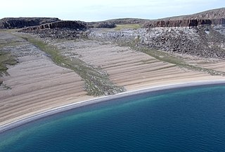
Bathurst Inlet is a deep inlet located along the northern coast of the Canadian mainland, at the east end of Coronation Gulf, into which the Burnside and Western rivers empty. The name, or its native equivalent Kingoak, is also used to identify the community of Bathurst Inlet located on the shore.
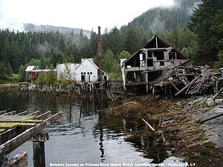
Butedale is a ghost town on Princess Royal Island, in British Columbia, Canada. It was founded in 1918 as a fishing, mining and logging camp. Initially the salmon cannery was established by Western Packers which was purchased and operated by the Canadian Fishing Company until it ceased operating in the 1950s. At its peak the summertime population of Butedale was over 400 people.
German submarine U-3519 was a Type XXI U-boat of Nazi Germany's Kriegsmarine during World War II. The Elektroboote submarine was laid down on 19 September 1944 at the Schichau-Werke yard at Danzig, launched on 23 November 1944, and commissioned on 6 January 1945 under the command of Kapitänleutnant Richard von Harpe.
German submarine U-217 was a Type VIID mine-laying U-boat of Nazi Germany's Kriegsmarine during World War II.

German submarine U-13 was a Type IIB U-boat of Nazi Germany's Kriegsmarine which was commissioned on 30 November 1936, following construction at the Deutsche Werke shipyards at Kiel. The first commander on board was Hans-Gerrit von Stockhausen. In her career she completed nine patrols, all while serving with the 1st U-boat Flotilla. The U-boat succeeded in sinking nine ships and damaging three more.
Gold Harbour, was a gold and silver mine and camp on Mitchell Inlet, part of Tasu Sound on Moresby Island in the Queen Charlotte Islands of the North Coast of British Columbia, Canada. It is notable as the location of the first lode mine worked in what is now British Columbia.
Milne Inlet is a body of water in Nunavut's Qikiqtaaluk Region. It flows in a southerly direction from Navy Board Inlet at the confluence of Eclipse Sound. Ragged Island is located at the inlet's opening, while Stephens Island is located further within. Baffinland had proposed in 2008 to build a harbour here. Then connecting the mine to Steensby Inlet, via a special cold-weather railway was planned in 2011. A few years later, after Baffinland's original environmental assessments had been approved, Baffinland announced that a fall in ore prices meant they could no longer justify the high capital cost of building the railway. Instead they proposed spending a smaller sum to construct a "tote road" that would allow ore to be trucked to Milne Inlet. They ended up building the road, and the harbour at Milne Inlet. The bulk carrier Federal Tiber departed from Milne Inlet on August 8, 2015, with the first shipment of ore from the mine.
SM UC-10 was a German Type UC I minelayer submarine or U-boat in the German Imperial Navy during World War I. The U-boat was ordered on 14 November 1914 and was launched on 15 July 1915. She was commissioned into the German Imperial Navy on 17 July 1915 as SM UC-10. Mines laid by UC-10 in her 30 patrols were credited with sinking 17 ships. UC-10 was torpedoed and sunk on 21 August 1916 by British submarine E54 at position 52°02′N03°54′E.
SM U-80 was one of the 329 submarines serving in the Imperial German Navy in World War I. U-80 was engaged in the naval warfare and took part in the First Battle of the Atlantic.
German submarine U-216 was a Type VIID mine-laying U-boat of Nazi Germany's Kriegsmarine during World War II. Her keel was laid down 1 January 1941 by Germaniawerft in Kiel as yard number 648. She was launched on 23 October 1941 and commissioned on 15 December 1941 with Oberleutnant zur See Karl-Otto Schultz in command.

Carbonate, also known as Carbonate Camp, West Virginia, Virginia, and Carbonate City (1881-1939), is a ghost town located in Lawrence County, South Dakota, United States.
German submarine U-2502 was a Type XXI U-boat of Nazi Germany's Kriegsmarine, built for service in World War II. The submarine was laid down on 25 April 1944 at the Blohm & Voss yard at Hamburg, launched on 15 June 1944, and commissioned on 19 July 1944 under the command of Kptlt. Gert Mannesmann, who commanded her until 8 April 1945.

German submarine U-1007 was a Type VIIC/41 U-boat of Nazi Germany's Kriegsmarine during World War II.

German submarine U-762 was a Type VIIC U-boat of Nazi Germany's Kriegsmarine during World War II.
German submarine U-927 was a Type VIIC U-boat of Nazi Germany's Kriegsmarine during World War II.
German submarine U-3503 was a Type XXI U-boat of Nazi Germany's Kriegsmarine, built for service in World War II. She was ordered on 6 November 1943, and was laid down on 17 June 1944 at F Schichau GmbH, Danzig, as yard number 1648. She was launched on 27 July 1944, and commissioned under the command of Oberleutnant zur See Hugo Deiring, on 9 September 1944.


