Related Research Articles

Port Isabel was a seaport established on Port Isabel Slough in 1865 during the American Civil War in Sonora, Mexico in the mouth of the Colorado River on the Gulf of California. It was founded to support the increased river traffic caused by the gold rush that began in 1862 on the Colorado River and the Yuma Quartermaster Depot newly established in 1864 to support the Army posts in the Arizona Military District. The slough was discovered in 1865 by the Captain W. H. Pierson of the schooner Isabel, that first used the slough to transfer its cargo to steamboats safe from the tidal bore of the Colorado River. Shortly afterward Port Isabel was established 3 miles up the slough and replaced Robinson's Landing as the place where cargo was unloaded in the river from seagoing craft on to flat bottomed steamboats of the Colorado River and carried up to Fort Yuma and points further north on the river.
Robinson's Landing was a location in Baja California, Mexico. It lay on the west bank of the Colorado River northwest of the north tip of Montague Island in the Colorado River Delta, 10 miles above the mouth of the river on the Gulf of California. Named for David C. Robinson, it was the place where cargo was unloaded in the river from seagoing craft on to flatbottomed steamboats and carried up to Fort Yuma and points further north on the river from 1852 onward. Joseph C. Ives, described it as it was in 1858, in his 1861 Report upon the Colorado river of the West The river here was subject to a severe tidal bore that formed in the estuary about Montague Island and propagated upstream and could on occasion swamp barges, boats and ships. By 1865, a better location was found, ships offloaded their cargos on the east bank of the river at Port Isabel, Sonora, northeast of Montague Island. 17 miles from Robinson's landing and 57 miles below Port Famine.
George Alonzo Johnson (1824–1903) was an American entrepreneur and politician.

El Dorado Canyon is a canyon in southern Clark County, Nevada famed for its rich silver and gold mines. The canyon was named in 1857 by steamboat entrepreneur Captain George Alonzo Johnson when gold and silver was discovered here. It drains into the Colorado River at the former site of Nelson's Landing.

Callville is a former settlement of Clark County in the U.S. state of Nevada. Abandoned in 1869, it was submerged under Lake Mead when the Colorado River was dammed, Callville Bay retaining the name. At one time, it was noted to be the southernmost outpost of the Mormon settlement.

Steamboats on the Colorado River operated from the river mouth at the Colorado River Delta on the Gulf of California in Mexico, up to the Virgin River on the Lower Colorado River Valley in the Southwestern United States from 1852 until 1909, when the construction of the Laguna Dam was completed. The shallow draft paddle steamers were found to be the most economical way to ship goods between the Pacific Ocean ports and settlements and mines along the lower river, putting in at landings in Sonora state, Baja California Territory, California state, Arizona Territory, New Mexico Territory, and Nevada state. They remained the primary means of transportation of freight until the advent of the more economical railroads began cutting away at their business from 1878 when the first line entered Arizona Territory.
Colorado, was a stern-wheel paddle-steamer, the third steamboat on the Colorado River, and first stern-wheel steamboat put on that river, in December 1855.
Cocopah, was a stern-wheel paddle-steamer, the fifth steamboat on the Colorado River, first put on the river in August 1859.
General Jesup was a side-wheel paddle-steamer, named for General Thomas Jesup then Quartermaster General of the United States Army, and was the second steamboat launched on the Colorado River, in 1854.

Cocopah II, was a stern-wheel paddle-steamer, the tenth steamboat on the Colorado River, first put on the river in 1867.
Esmerelda, was a stern-wheel paddle-steamer, built for the Sacramento River trade, in 1864 it became the first of the opposition steamboats on the Colorado River. It was also the first steamboat to tow large cargo barges on that river, in May 1864 and to reach Callville, Nevada in 1866.
Mohave was the first stern-wheel steamboat of that name running on the Colorado River between 1864 and 1875.
Colorado City is now a ghost town, in Clark County, Nevada, located under Lake Mohave at the mouth of El Dorado Canyon.
Nina Tilden, one of the two opposition stern-wheel steamboats that ran on the Colorado River from 1864 to 1868. Purchased by George A. Johnson Company it ran on the Colorado River from 1868 until 1874.
Olive City, or Olivia, was a short-lived town, steamboat landing, and ferry crossing on the Colorado River in what was then Yuma County, Arizona Territory, from 1863 to 1866. It was located on the Arizona bank of the Colorado River, 1 mile above its rival Mineral City and 1/2 mile above the original site of Ehrenberg, Arizona, 3 miles southwest of the location of La Paz. The GNIS location of Olive City (historical) is indicated as being in La Paz County, Arizona, but its coordinates in the present-day now put it across the river just within Riverside County, California. Olive City was named after Olive Oatman who had been, with her sister, survivors of the massacre of her family and a captive of the Yavapai until purchased from them by the Mohave who they lived with for several years.
George A. Johnson & Company was a partnership between three men who pioneered navigation on the Colorado River. Benjamin M. Hartshorne, George Alonzo Johnson and Alfred H. Wilcox. The George A. Johnson & Company was formed in the fall of 1852, and was reorganized as the Colorado Steam Navigation Company in 1869.
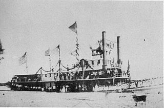
Mohave, the second stern-wheel steamboat of that name running on the Colorado River for the Colorado Steam Navigation Company (C.S.N.C) between 1875 and 1876. It was the first and only double smokestack steamboat to run on the river.
Jaeger's Slough, was a former course of the Colorado River, reduced to a slough sometime before 1849. It ran from its head on the north or California) bank of the river, from the main channel, that at that time ran two or three miles northwest and then east of Fort Yuma. The slough rejoined the river at its mouth nearly a mile west of Fort Yuma. The slough can be seen on Lieutenant Amiel Weeks Whipple's 1849 map "Map of a Survey and Reconnaissance of the Vicinity of the Mouth of the Rio Gila". The map shows two Quechan villages along either side of the slough. The slough would have flooded in the high water months of May and June and then been planted with crops as the water receded, the common practice of the native people along the Colorado River.
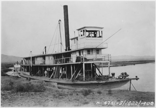
Cochan, (Quechan) last of the stern-wheel steamboats built for the Colorado Steam Navigation Company (CSNC). It ran on the Colorado River between 1900 and 1909.
Philips Point was a promontory on the north east bank of the Colorado River in Sonora, Mexico, that marked the mouth of the tidal estuary of the Colorado River in the later 19th century.
References
- 1 2 "The Arizona Sentinel, 1882-01-14, p. 2, col. 1 "What's in a Name?"". Archived from the original on 2015-11-25. Retrieved 2015-08-23.
- 1 2 The west coasts of Mexico and Central America from the United States to Panama including the gulfs of California and Panama: Chiefly from surveys by the United States steamers Narragansett, Tuscarora, Ranger, and Thetis, between 1873 and 1901; United States Hydrographic Office; Government Printing Office, 1904. pp.155-157