
Col du Tourmalet is one of the highest paved mountain passes in the French Pyrenees, in the department of Hautes-Pyrénées. Sainte-Marie-de-Campan is at the foot on the eastern side and the ski station La Mongie two-thirds of the way up. The village of Barèges lies on the western side, above the town of Luz-Saint-Sauveur.

The Col du Galibier is a mountain pass in the southern region of the French Dauphiné Alps near Grenoble. It is the eighth highest paved road in the Alps, and recurrently the highest point of the Tour de France.
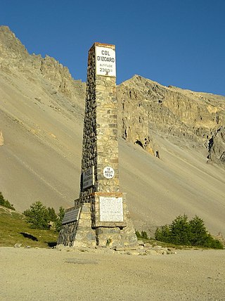
Col d'Izoard is a mountain pass in the Alps in the department of Hautes-Alpes in France.

Col du Glandon is a high mountain pass in the Dauphiné Alps in Savoie, France, linking Le Bourg-d'Oisans to La Chambre. It is situated between the Belledonne, Grandes Rousses and Arvan-Villards mountain ranges, west of the Col de la Croix de Fer. The road over the Col du Glandon was opened in 1898, although it was not linked to the Col de la Croix de Fer until 1912.

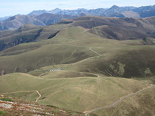
Plateau de Beille is a ski resort in the Pyrenees. It is situated in the Ariège department, and in the region of the Occitanie. The winter sports resort lies at a height of 1,790 m (5,870 ft).
The Port de Balès is a mountain pass in the central Pyrenees in the department of Hautes-Pyrénées in France. It connects the village of Ferrère to that of Bourg-d'Oueil, Haute-Garonne (south-east).
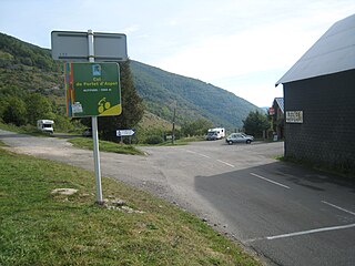
The Col de Portet d'Aspet is a mountain pass in the central Pyrenees in the department of Haute-Garonne in France. It is situated on the D618 road between Aspet and Saint-Girons and connects the Ger and Bouigane valleys, on the slopes of the Pic de Paloumère.

The Col de Menté is a mountain pass in the central Pyrenees in the department of Haute-Garonne in France. It is situated on the D44 road between Saint-Béat and the D618 and connects the Ger and Garonne valleys. Le Mourtis ski-station is located 1 km. south of the col.

The Col de Peyresourde is a mountain pass in the central Pyrenees on the border of the department of Haute-Garonne and Hautes-Pyrénées in France. It is situated on the D618 road between Bagnères-de-Luchon and Arreau.

The Port de Larrau is a mountain pass on the France – Spain border in the western Pyrenees between the department of Pyrénées-Atlantiques, France and Navarre, Spain. The climb from the French side was used in the 2007 Tour de France.

Col de Port is a mountain pass in the French Pyrenees between Massat and Tarascon-sur-Ariège in the "massif de l'Arize". It links the Couserans and Ariège valleys.

Col de Marie-Blanque is a mountain pass in the western Pyrenees in the department of Pyrénées-Atlantiques in France. The pass is situated south-east of Oloron-Sainte-Marie and connects the valleys of the Aspe and the Ossau rivers.
Semnoz is a mountain of Haute-Savoie, France. It lies in the Bauges range. It has an altitude of 1,699 m (5,574 ft) above sea level. The mountain is crossed by the D41/D110 road near to the Crêt de Chatillon at an altitude of 1,660 m (5,446 ft).

Col du Soulor is a mountain pass in the Pyrenees in France, linking Argelès-Gazost with Arthez-d'Asson. It connects the Ouzom and Arens valleys. A road leaves the pass to the west to reach the higher Col d'Aubisque.

Col d'Ornon is a mountain pass through the Dauphiné Alps in the department of Isère in France which connects the communities of Le Bourg-d'Oisans and La Mure. The climb is used occasionally in the Tour de France cycle race, including on the "Queen stage" on 18 July 2013 which finishes with two ascents to Alpe d'Huez.

The Col du Portillon is a mountain pass in the Pyrenees on the border between France and Spain. It connects Bagnères-de-Luchon in France with Bossòst in the Val d'Aran, Spain.

The Col du Grand Ballon is a mountain pass situated close to the summit of the Grand Ballon in the Vosges Mountains of France. It connects Cernay (Haut-Rhin) with Le Markstein winter sports station.
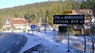
The Col du Bonhomme is a mountain pass in the Vosges Mountains of France. The pass connects Kaysersberg (Haut-Rhin) with Saint-Dié-des-Vosges (Vosges) (east–west) and is also crossed by the Route des Crêtes (north–south). The pass takes its name from the nearby village of Le Bonhomme, 6 km to the east.
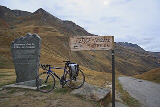
Col de Sarenne is a mountain pass located in the Grandes Rousses massif, approximately 9 km (6 mi) east of Alpe d'Huez in the Isère department of France. The pass connects Alpe d'Huez with the villages of Mizoën and Le Freney-d'Oisans in the Romanche valley. The road over the pass was used on Stage 18 of the 2013 Tour de France bicycle race as this loops round to enable the cyclists to climb the Alpe d'Huez twice in the same stage.
The Col du Petit Ballon is a mountain pass in the Vosges Mountains in the Haut-Rhin department of France, close to the summit of the Petit Ballon mountain.

