
Franklin County is a county along the Gulf of Mexico in the panhandle of the U.S. state of Florida. As of the 2010 census, the population was 11,549, making it the third-least populous county in Florida. The county seat is Apalachicola.

Wakulla County is a county located in the Big Bend region in the northern portion of the U.S. state of Florida. As of the 2010 census, the population was 30,776. Its county seat is Crawfordville.

Apalachicola is a city and the county seat of Franklin County, Florida, United States, on the shore of Apalachicola Bay, an inlet of the Gulf of Mexico. The population was 2,231 at the 2010 census.

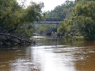
The Apalachicola River is a river, approximately 160 mi (180 km) long in the state of Florida. The river's large watershed, known as the ACF River Basin, drains an area of approximately 19,500 square miles (50,500 km2) into the Gulf of Mexico. The distance to its farthest head waters in northeast Georgia is approximately 500 miles (800 km). Its name comes from the Apalachicola people, who used to live along the river. It is the largest river in Florida.

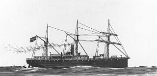
USS Mercedita (1861) was a wooden steamer that served as a gunboat in the Union Navy during the American Civil War.

USS Port Royal (1862) was a double-ended gunboat built for the U.S. Navy during the American Civil War. The vessel was assigned to patrol the rivers and other waterways of the Confederate States of America and to enforce the Union blockade on the South.
USS Sumpter was a steamship in the United States Navy during the American Civil War.
The third USS Montgomery was a wooden screw steamer in the Union Navy during the American Civil War.
Indian Pass is a small area on the south coast of Gulf County, Florida, 8 miles south of Port St. Joe. It promotes itself as an uncrowded haven for sports fisherman and water enthusiasts, and for dining featuring locally caught oysters. A ferry provides access to a wildlife sanctuary on St Vincent Island. Indian Pass is commonly thought of as one of the last bastions of "Old Florida" living.

The Cape St. George Light is a 72-foot (22 m) high brick lighthouse which had originally stood for 153 years on St. George Island, Florida, until toppling into the Gulf of Mexico October 22, 2005. The pieces of the lighthouse were retrieved, and in April 2008, the light's restoration was completed.

Apalachicola Bay is an estuary and lagoon located on the northwest coast of the U.S. state of Florida. The Apalachicola Bay system also includes St. George Sound, St. Vincent Sound and East Bay, covering an area of about 208 square miles (540 km2). Four islands, St. Vincent Island to the west, Cape St. George Island and St. George Island to the south, and Dog Island to the east, separate the system from the Gulf of Mexico. Water exchange occurs through Indian Pass, West Pass, East Pass and the Duer Channel. The lagoon has been designated as a National Estuarine Research Reserve and the Apalachicola River is the largest source of freshwater to the estuary. Combined with the Chattahoochee River, Flint River, and Ochlockonee River they drain a watershed of over 20,000 square miles (50,000 km2) at a rate of 19,599 cubic feet (550 m3) per second according to the United States Geological Survey in 2002.
The Ochlockonee River is a fast running river, except where it has been dammed to form Lake Talquin in Florida, originating in Georgia and flowing for 206 miles (332 km) before terminating in Florida.

CSS Chattahoochee was a twin-screw steam powered gunboat built at Saffold, Georgia; she was christened for the river upon which she was built. The gunboat entered Confederate States Navy service in February 1863.
USS Somerset was a wooden-hulled, side-wheel ferryboat built at Brooklyn, N.Y., in 1862, which was purchased by the Navy at Washington, D. C., on 4 March 1862 and was commissioned at the New York Navy Yard on 3 April 1862, Lt. Earl English in command.

USS Sagamore was a Unadilla-class gunboat built on behalf of the United States Navy for service during the American Civil War. She was outfitted as a gunboat and assigned to the Union blockade of the Confederate States of America. Sagamore was very active during the war, and served the Union both as a patrol ship and a bombardment vessel.
USS G. L. Brockenborough (1862) was a sloop captured by the Union Navy during the American Civil War.
USS Brockenborough (1862) was a sloop captured by the Union Navy during the American Civil War.
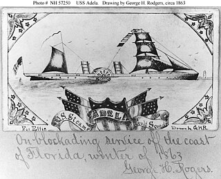
USS Adela (1862) was a steamer captured by the Union Navy during the American Civil War. She was used by the Union Navy as a gunboat in support of the Union Navy blockade of Confederate waterways.

The John Gorrie Bridge carries US 98 and US 319 over the Apalachicola Bay. It connects Apalachicola, Florida, with Eastpoint, Florida. The original John Gorrie Bridge was built in 1935, replacing a ferry service between the two towns. It included a rotating section to allow passage of ships with high masts. The current bridge was built in 1988.
New River is in the Florida Panhandle. It originates in the far north of the Apalachicola National Forest and joins with the Crooked River (Florida) above Carrabelle, Florida to become the Carrabelle River, which opens onto St. George Sound and the Gulf of Mexico. The New River watershed drains a large part of Liberty County, Florida with the Apalachicola River to the west and the Wakulla River to the east.


