
Indonesia's transport system has been shaped over time by the economic resource base of an archipelago with thousands of islands, and the distribution of its more than 200 million people concentrated mainly on a single island, Java.

Banten is the westernmost province on the island of Java, Indonesia. Its capital city is Serang and its largest city is Tangerang. The province borders West Java and the Special Capital Region of Jakarta on the east, the Java Sea on the north, the Indian Ocean on the south, and the Sunda Strait on the west and shares a maritime border with Bengkulu and Lampung to the east and Bangka Belitung Islands to the north. The province covers an area of 9,352.77 km2 (3,611.12 sq mi). It had a population of over 11.9 million in the 2020 census, up from about 10.6 million in 2010. The estimated mid-2023 population was 12.308 million. Formerly part of the province of West Java, Banten was split off to become a province on 17 October 2000.

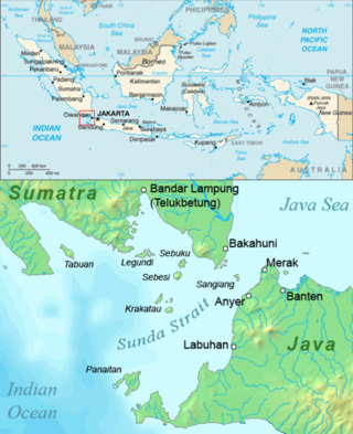
Lampung, officially the Province of Lampung, is a province of Indonesia. It is located on the southern tip of the island of Sumatra. It has a short border with the province of Bengkulu to the northwest, and a longer border with the province of South Sumatra to the north, as well a maritime border with the province of Banten and Jakarta to the east. It is the original home of the Lampung people, who speak their own language, and possess their own written script. Its capital is Bandar Lampung.

The Java Sea is an extensive shallow sea on the Sunda Shelf, between the Indonesian islands of Borneo to the north, Java to the south, Sumatra to the west, and Sulawesi to the east. Karimata Strait to its northwest links it to the South China Sea. It is a part of the western Pacific Ocean.
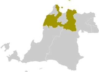
Serang Regency is a regency of Banten province, Indonesia. It is located in the northwest corner of the island of Java. The administrative center of the regency is at Ciruas, while the capital of the province is the independent municipality of Serang which was split off the regency on 17 July 2007.
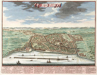
Banten, also written as Bantam, is a port town near the western end of Java, Indonesia. It has a secure harbour at the mouth of Banten River, a navigable passage for light craft into the island's interior. The town is close to the Sunda Strait through which important ocean-going traffic passes between Java and Sumatra. Formerly Old Banten was the capital of a sultanate in the area, was strategically important and a major centre for trade.

Cilegon is a major coastal industrial city in Banten province, Indonesia, covering 162.51 km2 (62.75 sq mi). It is located on the island of Java. The city had a population of 374,464 at the 2010 Census and 434,896 at the 2020 Census; the official estimate as at mid 2023 was 450,507 - comprising 228,360 males and 222,150 females.

Port of Merak is a seaport located in the Pulo Merak District of the city of Cilegon, Banten, on the northwestern tip of Java, Indonesia. The port and district are named after the green peafowl, which once lived in the region, but now only lives in the nearby Ujung Kulon National Park. The port is connected to Jakarta via the Jakarta-Merak Toll Road and is also connected to the Bakauheni port which is located at the south of the Trans-Sumatran Highway.
Madura Strait is a stretch of water that separates the Indonesian islands of Java and Madura, in the province of East Java. The islands of Kambing, Giliraja, Genteng, and Ketapang lie in the Strait. The Suramadu Bridge, the longest in Indonesia, spans the strait between Surabaya on Java and Bangkalan on Madura.

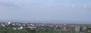
Anyer, also known as Anjer or Angier, is a coastal town in Banten, formerly West Java, Indonesia, 82 miles (100 km) west of Jakarta and 15 kilometers (9 mi) south of Merak. A significant coastal town late 18th century, Anyer faces the Sunda Strait.
Banten Bay, also known as Bantam Bay, is a bay in Banten province, near the northwest tip of Java, Indonesia. It is part of the Java Sea and has a total water surface of approximately 150 square kilometres and an average depth of 7 metres (23 ft). It includes marine ecosystems such as seagrass fields and coral reefs, and a major international bird sanctuary. The coastal zone, including the nearby cities of Serang and the port of Merak, is undergoing rapid industrialisation.

Bali Strait is a stretch of water separating Java and Bali while connecting the Indian Ocean and the Bali Sea. At its narrowest it is 2.4 kilometers (1.5 mi) wide.

Serang is a city and the capital of Banten province and was formerly also the administrative center of Serang Regency in Indonesia. The city is located towards the north of Banten province, on the island of Java; the north part of the city contains the coast zone facing onto Banten Bay, and includes the historical site of Old Banten, after which the province is named. Before Banten province was formed in 2000, Serang city was part of West Java province.
The Sunda Strait Bridge was a planned road and railway megaproject between the two large Indonesian islands of Sumatra and Java.
Sangiang is an island midway in the Sunda Strait between the Indonesian islands of Sumatra and Java. Administratively it is a part of Banten province of western Java. One current design for the ambitious Sunda Strait Bridge allows for part of the bridge to be built crossing the island. It is uninhabited due to its status as a nature preserve.
Pulau Legundi is an Indonesian island in the Sunda Strait between Java and Sumatra. It is one of the larger islands in the Strait and lies at the western end of Sumatra's Lampong Bay, in the province of Lampung.

Port Link is a ro-pax ferry that was formerly operated by Sealink and Stena Line between Holyhead and Dun Laoghaire and later Stranraer and Larne / Belfast. Now it is used by ASDP Indonesia Ferry for Merak to Bakauheni line.

The Jakarta–Merak Toll Road is a toll road connecting Jakarta and the Port of Merak in Cilegon, Banten, Indonesia. Having a total length of 98 kilometres (61 mi), this toll road is a part of the Trans-Java Toll Road and divided into 2 sections: the 26 kilometres (16 mi) long Jakarta–Tangerang Toll Road and the 72 kilometres (45 mi) long Tangerang–Merak Toll Road. It is generally used by people to travel back and forth between Sumatra and the cities of Java. This toll road is also a part of Asian Highway 2.

MV Laut Teduh II was an Indonesian-flagged double-ended RO/RO passenger ferry that served the route from the Port of Merak in Java to the Port of Bakauheni in Sumatra, one of the busiest ferry routes in Indonesia. She was built in 1988 in England and was registered as Laut Teduh II in 2007.


