Selangor, also known by the Arabic honorific Darul Ehsan, or "Abode of Sincerity", is one of the 13 states of Malaysia. It is on the west coast of Peninsular Malaysia and is bordered by Perak to the north, Pahang to the east, Negeri Sembilan to the south, and the Strait of Malacca to the west. Selangor surrounds the federal territories of Kuala Lumpur and Putrajaya, both of which were previously part of it. Selangor has diverse tropical rainforests and an equatorial climate. The state's mountain ranges belong to the Titiwangsa Mountains, which is part of the Tenasserim Hills that covers southern Myanmar, southern Thailand and Peninsular Malaysia, with Mount Semangkok as the highest point in the state.

Negeri Sembilan, historically spelled as Negri Sembilan, is a state in Malaysia which lies on the western coast of Peninsular Malaysia. It borders Selangor on the north, Pahang in the east, and Malacca and Johor to the south.
Port Dickson, colloquially referred to as PD is a beach resort in Port Dickson District, Negeri Sembilan, Malaysia. It is the second largest urban area in Negeri Sembilan after Seremban, its state capital. The town's administration is run by the Port Dickson Municipal Council, formerly known as the Port Dickson Sanitary Board from 29 March 1928 until 28 February 1950, Port Dickson Town Board from 1 March 1950 until 30 November 1979, Port Dickson District Council from 1 December 1979 until 1 February 2002.
Seri Kembangan, also known as Serdang, formerly known as Serdang New Village, is a town located in Petaling District, Selangor, Malaysia. It is located in between Kuala Lumpur and Putrajaya. The town is now a considerable city in size. It is located near the northern end of the PLUS Expressway Southern Route North–South Expressway Southern Route.
The North–South Expressway Southern RouteNorth–South Expressway Southern Route is an interstate controlled-access highway running parallel to the southwestern coast of Peninsular Malaysia. The expressway forms the south section of the North–South Expressway, connecting the states of Selangor, Negeri Sembilan, Malacca and Johor. It begins at Seri Kembangan, near the state/territory boundary between Selangor and Kuala Lumpur, and travels southwards to end at Pandan-Tebrau in Johor.
The Klang River is a river which flows through Kuala Lumpur and Selangor in Malaysia and eventually flows into the Straits of Malacca. It is approximately 120 km (75 mi) in length and drains a basin of about 1,288 km2 (497 sq mi). The Klang River has 11 major tributaries.

The term "British Malaya" loosely describes a set of states on the Malay Peninsula and the island of Singapore that were brought under British hegemony or control between the late 18th and the mid-20th century. Unlike the term "British India", which excludes the Indian princely states, British Malaya is often used to refer to the Federated and the Unfederated Malay States, which were British protectorates with their own local rulers, as well as the Straits Settlements, which were under the sovereignty and direct rule of the British Crown, after a period of control by the East India Company.
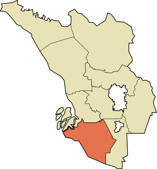
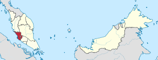
The Kuala Langat District is a district of Selangor, Malaysia. It is situated in the southwestern part of Selangor. It covers an area of 858 square kilometres, and had a population of 307,787 at the 2020 Census. It is bordered by the districts of Klang and Petaling to the north and Sepang to the east. The Strait of Malacca forms its western border.
Sungai Besi is a town and suburb within the Federal Territory of Kuala Lumpur. The federal constituency of Sungai Besi existed from 1974 to 1995. Sungai Besi was a historical mining town with many heavy industries such as steelworks, waste steel plants and other steel industries. Sungei Besi Tin Mine site was the largest and deepest open cast alluvial tin mine in the world and in Malaysia. The town has since developed from a large area of village settlements.

The Selangor River is a major river in Selangor, Malaysia. It runs from Kuala Kubu Bharu in the east and empties into the Straits of Malacca at Kuala Selangor in the west.

Rantau is a small town and a mukim in Seremban District, Negeri Sembilan, Malaysia.
Federal Route 138 is a federal road in Malacca, Malaysia, connecting Masjid Tanah and Kuala Linggi. It was originally known as Jalan Kuala Sungai Baru-Sungai Udang and Jalan Lubuk Redan-Masjid Tanah. Federal Route FT 138 features Sungai Linggi Bridge and was built to provide a shorter, less-winding alternative to Federal Route 5 for journeys from Malacca City to Port Dickson. Kilometre Zero of Federal Route 138 is at Kampung Jeram near Masjid Tanah.
Kuala Sungai Baru is a mukim and town in Alor Gajah District, Malacca, Malaysia, with fishing as main economic activity. It is situated midway between Kuala Linggi and Pengkalan Balak and is approximately 15 kilometers from Masjid Tanah.

Eye on Malaysia was a transportable Ferris wheel installation in Malaysia. It began operating in Kuala Lumpur in 2007, and was then moved to Malacca in 2008, where it operated until 2010.

Ampangan is a suburb and a mukim in Seremban District, Negeri Sembilan, Malaysia.

Malacca, officially the Historic State of Malacca, is a state in Malaysia located in the southern region of the Malay Peninsula, facing the Strait of Malacca. The state is bordered by Negeri Sembilan to the north and west and Johor to the south. The exclave of Tanjung Tuan also borders Negeri Sembilan to the north. Its capital is Malacca City, which has been listed as a UNESCO World Heritage Site since 7 July 2008.

Seremban is a city in the Seremban District and the capital of the state of Negeri Sembilan in Peninsular Malaysia. The city's administration is run by the Seremban City Council. Seremban gained its city status on 20 January 2020.

The Royal Malaysian Customs Department Museum is a museum about Royal Malaysian Customs Department in Malacca City, Malacca, Malaysia.

The East Coast Rail Link (ECRL) is a standard gauge double-track railway link infrastructure project connecting Port Klang on the Straits of Malacca to Kota Bharu in northeast Peninsular Malaysia, connecting the East Coast Economic Region states of Pahang, Terengganu and Kelantan to one another, and to the Central Region of the Peninsula's west coast.
Port of Kuala Tanjung is a sea port at Batubara Regency, North Sumatra, Indonesia. Once fully functional the port can accommodate 60 million TEUs per year as the biggest port in West Indonesia, bigger than Port of Tanjung Priok in Jakarta. The first phase of development of Kuala Tanjung Multipurpose Terminal was inaugurated in 2018. The first ship to dock at the port was the cruise ship SuperStar Libra on 5 April 2018 from Port Klang, Malaysia. The port made its debut in the global container market, with its first shipment on 28 March, 2020.


