
The Neman, Niemen or Nemunas is a river in Europe that rises in central Belarus and flows through Lithuania then forms the northern border of Kaliningrad Oblast, Russia's western exclave, which specifically follows its southern channel. It drains into the Curonian Lagoon, narrowly connected to the Baltic Sea. The 937 km (582 mi) long Neman is a major Eastern European river. It flows generally west to Grodno within 12 kilometres (7.5 mi) of the Polish border, north to Kaunas, then westward again to the sea.

A pier is a raised structure that rises above a body of water and usually juts out from its shore, typically supported by piles or pillars, and provides above-water access to offshore areas. Frequent pier uses include fishing, boat docking and access for both passengers and cargo, and oceanside recreation. Bridges, buildings, and walkways may all be supported by architectural piers. Their open structure allows tides and currents to flow relatively unhindered, whereas the more solid foundations of a quay or the closely spaced piles of a wharf can act as a breakwater, and are consequently more liable to silting. Piers can range in size and complexity from a simple lightweight wooden structure to major structures extended over 1,600 m (5,200 ft). In American English, a pier may be synonymous with a dock.

Neringa or Neringa Municipality is a municipality of Klaipėda County in westernmost Lithuania, comprising several villages in the Curonian Spit. In terms of population, it is the smallest municipality of the country. Nida is the seat of government and largest town in Neringa Municipality.

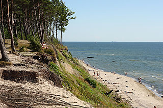
The Curonian (Courish) Spit is a 98-kilometre (61 mi) long, thin, curved sand-dune spit that separates the Curonian Lagoon from the Baltic Sea. It is a UNESCO World Heritage Site shared by Lithuania and Russia. Its southern portion lies within Kaliningrad Oblast of Russia, and its northern within southwestern Klaipėda County of Lithuania.
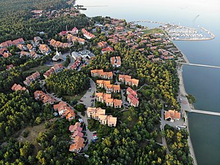
Nida is a resort town in Lithuania, the administrative centre of Neringa municipality. Located on the Curonian Spit between the Curonian Lagoon and the Baltic Sea, it is the westernmost point of Lithuania and the Baltic states, close to the border with the Russian Kaliningrad Oblast exclave. It currently has about 2,385 residents.

Smiltynė is a part of Klaipėda city municipality in Lithuania. It is located on the northern tip of the Curonian Spit, next to Kopgalis, which is at the very tip of the spit pointing into the narrow strait which connects the Curonian Lagoon to the Baltic Sea. Across the 0.5-kilometre wide (0.31 mi) strait, on the Lithuanian mainland, is the port city of Klaipėda. Ferries transport vehicles and people daily between the two cities across the strait, as there is no connecting bridge. Smiltynė serves as a public beach for Klaipėda residents, as ports take up the coastline around Klaipėda.
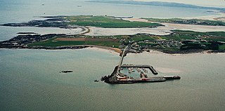
Fenit is a small village in County Kerry, Ireland, located on north side of Tralee Bay about 10 km (6 mi) west of Tralee town, just south of the Shannon Estuary. It is also a civil parish. The bay is enclosed from the Atlantic by the Maharee spit which extends northwards from the Dingle peninsula. Fenit harbour is a mixed function sea port, where fishing, freight import and export, and a 136 berth marina are the main forms of business. As of the 2022 CSO census of Ireland, Fenit had a population of 619 people.

Juodkrantė is a Lithuanian seaside resort town located on the Curonian Spit with a permanent population of about 720 people. A part of Neringa municipality, Juodkrantė is the second largest settlement on Lithuania's part of the spit. For centuries it was a fishing village, which underwent a tourist boom in the late 19th–early 20th century.
Rybachy is a rural settlement in Zelenogradsky District of Kaliningrad Oblast, Russia, located on the Curonian Spit. As of 2010 it has about 839 residents. It was formerly known for the Rossitten Bird Observatory and the Rossitten gliding school.

The Berkeley Marina is the westernmost portion of the city of Berkeley, California, located west of the Eastshore Freeway at the foot of University Avenue on San Francisco Bay. Narrowly speaking, "Berkeley Marina" refers only to the city marina, but in common usage, it applies more generally to the surrounding area. The Berkeley Marina is a hub for various water activities, offering opportunities for kayaking, stand-up paddleboarding, windsurfing, open-water swimming, and kiteboarding. Outdoor enthusiasts gather to enjoy the scenic bay, catch the wind for a sail, or practice their water sports skills.
The Kursenieki are a nearly extinct Baltic ethnic group living along the Curonian Spit. "Kuršiai" refers only to inhabitants of Lithuania and former East Prussia that speak a southwestern dialect of Latvian. Some autochthonous inhabitants of Šventoji in Lithuania call themselves "kuršiai" as well.

The Port of Southampton is a passenger and cargo port in the central part of the south coast of England. The modern era in the history of the Port of Southampton began when the first dock was inaugurated in 1843. After the Port of Felixstowe, Southampton is the second largest container terminal in UK, with a handled traffic of 1.5 million twenty-foot equivalent units (TEU). It also handles cruise ships, roll-on roll-off, dry bulk, and liquid bulk.

USS Sylph (PY-5) was a steel hulled steam yacht that served as a presidential yacht operating from the Washington Navy Yard from the late 19th century through the presidency of Woodrow Wilson. Afterwards the yacht was used by the Secretary of the Navy and Assistant Secretary of the Navy. After decommissioning and sale in 1929 the yacht was used as a party fishing boat in New York and later a ferry. Sometime around 1950 the line went out of business and the vessel was abandoned at a pier at West 37th Street, Sea Gate, Brooklyn. The pier and abandoned vessel were reduced by fire and storms to the waterline and wreckage in the sands which still may be exposed by storms.

Douglas Harbour is located near Douglas Head at the southern end of Douglas, the capital of the Isle of Man. It is the island's main commercial shipping port. The Port of Douglas was the first in the world to be equipped with radar.
Hornblower Cruises is a San Francisco–based charter yacht, dining cruise and ferry service company. In 2021, the company rebranded most of its services as City Cruises or City Experiences. In 2024, the company filed for bankruptcy protection.

The Port of Skagen, also Skagen Harbour, is located in Skagen, northern Denmark. The country's leading fishing port consists of an industrial harbour that supports the area's fishing industry as well as facilities for cruise ships. It also has a shipyard and fish-processing facilities. The harbour's marina is open to visitors during the summer months.
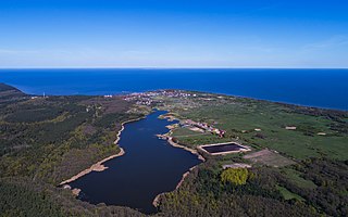
Seaside Regional Park is a regional park located on the coast of the Baltic Sea in Western Lithuania. 54% of its 5,602 ha is sea and 36% forest. The administration offices are in Karklė. The park was founded in order to preserve the continental coastal landscapes/seascapes, the natural and cultural heritage properties, the biological diversity of the Baltic Sea, and the marine boulder beds.

Rusnė Island is an island in Nemunas Delta, Šilutė District Municipality, Lithuania. It is located between Atmata and Skirvytė, distributaries of the Neman River, and the Curonian Lagoon. At 45 or 46 square kilometers, Rusnė is often considered Lithuania's largest island.

Preila is a settlement in the Neringa Municipality, Lithuania. It is located on the Preila Bay of the Curonian Lagoon). Preila is situated about 2 kilometres (1.2 mi) away from the Baltic Sea and 6 kilometres (3.7 mi) north of Nida, which is a popular tourist destination. The village is surrounded by many dunes: Preila Hill, Vecekrugas Hill, and Karvaičiai Hill.

The Curonian weathervane is a unique decoration of boats, created by fishermen of the Curonian Lagoon in Lithuania. The weather vanes have been used for identifications, as well as decoration and indication of the direction of wind.


