Portland Square, Bristol

Last updated

Portland Square
Portlandsquare2.JPG
North side
Bristol UK location map.svg
Red pog.svg
Location St Paul's, Bristol, England
Coordinates 51°27′41″N2°35′10″W / 51.4615°N 2.5861°W / 51.4615; -2.5861 Coordinates: 51°27′41″N2°35′10″W / 51.4615°N 2.5861°W / 51.4615; -2.5861
OS grid ST596742
St. Paul's church St Paul Bristol - geograph.org.uk - 1726298.jpg
St. Paul's church

Portland Square (grid reference ST594737 ) is a Grade I listed square in the St Paul's area of Bristol. [1]

Contents

It was laid out in the early 18th century as one of Bristol's first suburbs. Built upon a flat area of ground its central focus of St. Paul's Church. Shortly after construction started a number of the builders involved in the project became bankrupt, leaving much of the Square unfinished.

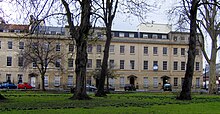
A variety of Georgian architecture designed by Daniel Hague was designed for wealthy occupants, although some has since fallen into disrepair or been converted from residential occupation to offices. It is laid out around a central gardens. The gates and railings of which are a grade II listed building. [2]

Notable residents

Architecture

Many of the buildings now have Grade I listed building status.

Numbers 11 and 12 have been demolished, but not before a major archaeological investigation was undertaken first. It showed that site of Nos 11–12 Portland Square consisted of two joined structures. On the western side along the street frontage, no. 11 was occupied by a Georgian House, with a courtyard to the rear. In 1877, no. 12 was converted for use as Young and Melrow's stay factory. [9]

Numbers 31 and 32 are on the Historic England Buildings at Risk Register and described as being in very bad condition. [10]

West side Portlandsquare.JPG
West side

Decline

The area never achieved the fashionable cachet anticipated by the scale of the architecture and St Paul's church, being soon eclipsed by Clifton. Rather than the fine domestic residences planned by the developers, by the end of the 19th century there were many small business based around the square, particularly involving boot & shoe manufacture, and ancillary services for printing such as ink making and cardboard box making. [11] By 1916 the Salvation Army opened two hostels for men and women in the area. [note 1]

Bristol suffered from heavy bombing in World War II and Portland Square did not escape. A raid on 2 December 1940 killed 40 people and destroyed Dean Street, to the North of the Square. [11] After the war, there was little interest in large Georgian properties [note 2] and by 1951 the Ordnance Survey map described parts of the Square as "in ruins". [11] Bristol's brutalist planning and development policies in the 1960s did nothing to repair this damage, particularly in the adjoining Brunswick Square. Unlike its neighbour, Portland Square did at least maintain its railed gardens and trees through the wartime scrap metal drives, which left the Square with some residual sense of coherence.

Portland & Brunswick Square was first designated as a Conservation Area in 1974, with extensions to this in the years following. [12] Despite this, little progress was made and the North West corner of the Square still required timber shoring to support buildings damaged by wartime bomb damage.

A gradual decline of St Paul's in general reached its nadir around the rioting of 1980. Both Portland and Brunswick squares developed a reputation for prostitution and drug-dealing. [13] [14]

Redevelopment

Bristol's generally booming economy in the 1990s encouraged some restoration and sympathetic redevelopment, initially on a small scale by individuals and businesses. Cosie's wine bar [15] and the Surrey Wine Vaults [16] were bohemian destinations for Bristol's vibrant nightlife, despite the area's threatening reputation – a reputation far less deserved in these main squares than in some nearby streets.

FTP which then became Galaxy Radio 97.2 The Hot FM was based at No 25.

One of the first major projects, the inspiration of its founding director June Burrough, was the Pierian Centre, a self-contained centre for training and self-development. [17] This opened in 2002 in the Grade I listed No 27 and closed in December 2011 due to lack of funding. [18] The most visible development was in 2004, the opening of St Pauls church (closed in 1988) as the Circomedia centre of excellence for circus and theatre training. [19]

Portland Square featured in the BBC Doctor Who 2012 Christmas Special, "The Snowmen". Filming took place overnight on 21–22 August 2012. It stood in for central London for the bonfire scene in the Sherlock episode "The Empty Hearse".[ citation needed ]

Footnotes

  1. The Salvation Army continues in the area, although now moved North onto Ashley Road.
  2. This also affected similar properties in Clifton

Notes

  1. "Portland & Brunswick Square: Character Appraisal" (PDF). Bristol City Council. May 2008. p. 4. Archived from the original (PDF) on 10 January 2012.
  2. "Gates and railings round Portland Square gardens". historicengland.org.uk. Retrieved 22 February 2007.
  3. "Nos.1–6 (Consecutive) and attached area railings". historicengland.org.uk. Retrieved 22 February 2007.
  4. "Nos.14–17 (Consecutive) and attached area railings". historicengland.org.uk. Retrieved 22 February 2007.
  5. "Nos.18–21 (Consecutive) and attached area railings". historicengland.org.uk. Retrieved 22 February 2007.
  6. "Nos.22–28 (Consecutive) and attached area railings". historicengland.org.uk. Retrieved 22 February 2007.
  7. "Nos.31–34 (Consecutive) and attached area railings". historicengland.org.uk. Retrieved 22 February 2007.
  8. "Nos.7–13 (Consecutive) and attached area railings". historicengland.org.uk. Retrieved 22 February 2007.
  9. "11–12 Portland Square". Cotswold Archeology. Archived from the original on 25 September 2006. Retrieved 22 February 2007.
  10. "31 and 32 Portland Square, Portland Squaret". English Heritage Buildings at Risk Register. Retrieved 10 May 2007.
  11. 1 2 3 Bristol Council & Character Appraisal , p. 8
  12. Bristol Council & Character Appraisal , p. 9
  13. "Mixed reaction in Bristol to new powers to tackle prostitution". This Is Bristol. 19 November 2008. Archived from the original on 18 April 2012.
  14. "Bristol kerb crawler, 74, caught with trousers down". 23 September 2009. Archived from the original on 5 May 2013.
  15. "Cosies Bistro Wine Bar and Club - Bristol". Archived from the original on 23 March 2012. Retrieved 4 April 2012.
  16. "St Pauls". Avon Packet. Archived from the original on 21 September 2011.
  17. "The Pierian Centre". 18 April 2022.
  18. http://pierian-centre.com/the-program/ [ dead link ]
  19. "Home". circomedia.com.

Related Research Articles

<span class="mw-page-title-main">Bristol Museum & Art Gallery</span> Museum in Bristol, UK

Bristol Museum & Art Gallery is a large museum and art gallery in Bristol, England. The museum is situated in Clifton, about 0.5 miles (0.8 km) from the city centre. As part of Bristol Culture it is run by the Bristol City Council with no entrance fee. It holds designated museum status, granted by the national government to protect outstanding museums. The designated collections include: geology, Eastern art, and Bristol's history, including English delftware. In January 2012 it became one of sixteen Arts Council England Major Partner Museums.

<span class="mw-page-title-main">Southville, Bristol</span> Human settlement in England

Southville is an inner city ward of Bristol, England, on the south bank of the River Avon northwest of Bedminster. Most of the area's houses were built in the late 19th and early 20th centuries for workers in the Bristol coal mining industry or the tobacco factories of W. D. & H. O. Wills, homes of the eponymous "Wills Girls". The world headquarters of Imperial Tobacco, the world's fourth largest international tobacco company, used to be here, but moved to Ashton. Southville was also a centre for the tanning industry.

St Pauls is an inner suburb of Bristol, England, situated just northeast of the city centre and west of the M32. It is bounded by the A38, the B4051, the A4032 and the A4044, although the River Frome was traditionally the eastern boundary before A4032 was constructed. St Pauls was laid out in the early 18th century as one of Bristol's first suburbs.

<span class="mw-page-title-main">Buildings and architecture of Bristol</span>

Bristol, the largest city in South West England, has an eclectic combination of architectural styles, ranging from the medieval to 20th century brutalism and beyond. During the mid-19th century, Bristol Byzantine, an architectural style unique to the city, was developed, and several examples have survived.

<span class="mw-page-title-main">Victoria Rooms, Bristol</span> Building of the University of Bristol

The Victoria Rooms, also known as the Vic Rooms, houses the University of Bristol's music department in Clifton, Bristol, England, on a prominent site at the junction of Queens Road and Whiteladies Road. The building, originally assembly rooms, was designed by Charles Dyer and was constructed between 1838 and 1842 in Greek revival style, and named in honour of Queen Victoria, who had acceded to the throne in the previous year. An eight column Corinthian portico surmounts the entrance, with a classical relief sculpture designed by Musgrave Watson above. The construction is of dressed stonework, with a slate roof. A bronze statue of Edward VII, was erected in 1912 at the front of the Victoria Rooms, together with a curved pool and several fountains with sculptures in the Art Nouveau style.

<span class="mw-page-title-main">Park Street, Bristol</span>

Park Street is a major shopping street in Bristol, England, linking the city centre to Clifton. It forms part of the A4018.

<span class="mw-page-title-main">Brunswick, Hove</span> House in Brighton and Hove, East Sussex

Brunswick Town is an area in Hove, in the city of Brighton and Hove, England. It is best known for the Regency architecture of the Brunswick estate.

<span class="mw-page-title-main">St Paul's Church, Bristol</span> Church in Bristol, England

St Paul's Church gives its name to the surrounding St Paul's area of Bristol. It was built in the 1790s but fell into disuse and disrepair by its closure in 1988. It is recorded in the National Heritage List for England as a designated Grade I listed building.

<span class="mw-page-title-main">Grade I listed buildings in Bristol</span>

There are 100 Grade I listed buildings in Bristol, England according to Bristol City Council. The register includes many structures which for convenience are grouped together in the list below.

There are 212 Grade II* listed buildings in Bristol, England.

There are many Grade II listed buildings in Bristol, United Kingdom.

<span class="mw-page-title-main">Berkeley Square, Bristol</span> Area in Bristol, England

Berkeley Square is an area close to Park Street in the Clifton area of Bristol that includes buildings and a central area of greenery.

<span class="mw-page-title-main">Dowry Square</span>

Dowry Square is in the Hotwells area of Bristol.

<span class="mw-page-title-main">Bristol Byzantine</span> Byzantine Revival architecture in Bristol, England

Bristol Byzantine is a variety of Byzantine Revival architecture that was popular in the city of Bristol from about 1850 to 1880.

<span class="mw-page-title-main">Grade I listed buildings in Somerset</span> Buildings of exceptional interest in Somerset

The Grade I listed buildings in Somerset, England, demonstrate the history and diversity of its architecture. The ceremonial county of Somerset consists of a non-metropolitan county, administered by Somerset County Council, which is divided into five districts, and two unitary authorities. The districts of Somerset are West Somerset, South Somerset, Taunton Deane, Mendip and Sedgemoor. The two administratively independent unitary authorities, which were established on 1 April 1996 following the breakup of the county of Avon, are North Somerset and Bath and North East Somerset. These unitary authorities include areas that were once part of Somerset before the creation of Avon in 1974.

<span class="mw-page-title-main">Royal York Crescent</span>

Royal York Crescent is a major residential street in Clifton, Bristol. It overlooks much of the docks, and much of the city can be seen from it. It also joins Clifton Village at one end. It is one of the most expensive streets in the city.

<span class="mw-page-title-main">Grade I listed buildings in Brighton and Hove</span>

There are 24 Grade I listed buildings in the city of Brighton and Hove, England. The city, on the English Channel coast approximately 52 miles (84 km) south of London, was formed as a unitary authority in 1997 by the merger of the neighbouring towns of Brighton and Hove. Queen Elizabeth II granted city status in 2000.

<span class="mw-page-title-main">Grade II* listed buildings in Brighton and Hove</span>

There are 72 Grade II* listed buildings in the city of Brighton and Hove, England. The city, on the English Channel coast approximately 52 miles (84 km) south of London, was formed as a unitary authority in 1997 by the merger of the neighbouring towns of Brighton and Hove. Queen Elizabeth II granted city status in 2000.

<span class="mw-page-title-main">Berkeley Crescent, Bristol</span> Building in Bristol, England

Berkeley Crescent is a late 18th-century crescent of six Georgian houses with a private communal garden.