Potter Valley Project

Last updated
Map of the Potter Valley Project Potter Valley Project.png
Map of the Potter Valley Project
Lake Pillsbury, the project's primary reservoir Lake Pillsbury.JPG
Lake Pillsbury, the project's primary reservoir

The Potter Valley Project is an interbasin water transfer project in Northern California in the United States, delivering water from the Eel River basin to turbines in the headwaters of the Russian River. [1] The project is owned and operated by Pacific Gas and Electric Company (PG&E). The main facilities are two dams on the Eel River, a diversion tunnel and hydroelectric plant. [2] Average annual throughput is 159,000 acre⋅ft (196,000,000 m3), although this figure varies significantly with both the amount of precipitation in the Eel River basin and the demand on the Russian River. [3]

Contents

In 2019, PG&E chose not to relicense the hydroelectric project with the Federal Energy Regulatory Commission, as it had become unprofitable to operate. Federal regulations require that PG&E submit a final license surrender application by 2025, which would enable it to begin decommissioning the project. [4] [5] The dams and hydroelectric facilities are to be removed, while various options are being considered for maintaining water diversions to the Russian River. [6]

History

Construction on the project began in 1900, when The Eel River Power and Irrigation Company (later the Snow Mountain Water and Power Company) constructed the Cape Horn Dam and a one-mile (1.6 km), 8-foot (2.4 m)-diameter tunnel under the drainage divide to Potter Valley, at the headwaters of the East Fork Russian River. [7] The water dropped 450 feet (140 m) to a powerhouse before being released to the East Fork Russian River. On April 1, 1908, the first deliveries were made and power production began with a capacity of 4000 kilowatts (KW). In 1910, the generation capacity was boosted to 7000 KW and in 1912 second penstock was built to increase the flow capacity of the tunnel. The powerhouse was upgraded to 9400 KW in 1917, after the addition of a fourth unit. [2]

Initially, the project could only operate during the winter months, when there was enough water in the Eel River to divert without drying up the riverbed downstream. In 1920, Snow Mountain Water and Power began construction on a larger dam on the Eel River, 12 miles (19 km) upstream from Cape Horn. Scott Dam, which forms Lake Pillsbury, was completed in 1922. With its greater storage capacity, it provides water for the diversion during the summer months and also affords some flood control during winter storms. [2] In 1930, ownership of the project was transferred to PG&E. In 1959, Coyote Valley Dam was built on the Russian River as part of the separate Russian River Basin Project (RRBP), forming Lake Mendocino, which provides additional storage of diverted Eel River waters. This reservoir serves a critical function during dry years as it is drawn down to compensate for reduced diversions from the Eel River system. [8]

The Federal Energy Regulatory Commission relicensing of the project on January 28, 2004, placed limits on the amount of water than can be diverted. In combination with drought conditions, diversions between 2004 and 2009 averaged 90,000 acre-feet (110,000,000 m3), or 57% of the historical average. Since then, late summer water has been released from Cape Horn Dam at rates roughly mimicking or exceeding natural flows in an attempt to mitigate the impacts to fisheries.[ citation needed ]

Operations

The project derives water from a drainage basin of 289 square miles (750 km2) above Scott Dam and approximately 50 square miles (130 km2) between Scott Dam and Cape Horn Dam, where water is diverted to the Russian River. The vast majority of the water arrives as winter rain between December and April, with a smaller, less reliable amount furnished by snowmelt and groundwater through June. Scott Dam, which forms Lake Pillsbury, has a total storage capacity of 74,993 acre-feet (92,503,000 m3). Project regulations require that the gates at Scott Dam be opened between October 16 and April 1, for safety reasons during the winter months. Winter storms fill the reservoir, which provides only very limited flood control, because the average annual runoff of 400,000 acre-feet (490,000,000 m3) is over five times the project storage capacity. It is not uncommon for the dams to spill eight or nine times during a single winter season. After the wet season passes, Lake Pillsbury is drawn down beginning April 1. Typical summer drawdowns leave the reservoir at or above 20,000 acre-feet (25,000,000 m3), or 27 percent capacity. Water is released to Cape Horn Dam, which diverts the majority, while releasing a small flow to the Eel River designed to mimic natural summer flows. This is typically around 20 cubic feet per second (0.57 m3/s), but can decrease significantly during dry years. [9]

Beneficiaries

In 1924, the Potter Valley Irrigation District (PVID) was formed to provide irrigation water to the farmers along the East Branch Russian River. The district currently serves 390 farmers with rights to 22,670 acre-feet (27,960,000 m3) of project water per year, for the irrigation of 4,905 acres (1,985 ha) within a district boundary of 6,900 acres (2,800 ha). [10] Because there is very little natural runoff in Potter Valley and the local geology is non-conducive to groundwater storage, the PVID is the only constituent that depends solely on Eel River water. [11]

Project water also serves farmers and municipalities downstream along the Russian River, in Mendocino County. The total water use per year is about 17,000 to 23,000 acre-feet (21,000,000 to 28,000,000 m3). Even further downstream, water users in Sonoma County use between 50,000 and 80,000 acre-feet (62,000,000 and 99,000,000 m3) per year. These users depend both on Potter Valley Project water and natural flows in the Russian River basin managed by the RRBP. In addition to agricultural, domestic and industrial uses, project water helps to maintain a minimum dry season flow of 150 cubic feet per second (4.2 m3/s) in the Russian River, serving for recreational, aesthetic and fishery enhancement purposes. [11] Project water is estimated to provide at least part of the water supply for nearly 500,000 people living in Sonoma and Mendocino Counties, mainly in the North Bay area, for cities such as Santa Rosa. [2]

Environmental impact

The Potter Valley Project has had a significant impact on summer low streamflows in the Eel River basin. Although the project taps water from only the upper 10% of the Eel River system, this headwaters region provides most of the summer flow in the lower Eel, especially during critically dry years, when only 5 cubic feet per second (0.14 m3/s) are allowed into the Eel River past the Cape Horn diversion point. As a result, summer-run salmon and steelhead in the Eel River are negatively affected during dry years. In addition, while Cape Horn Dam has a fish ladder, the larger Scott Dam blocks fish migration to about 100 miles (160 km) of habitat in the Eel River headwaters. [12]

See also

Related Research Articles

<span class="mw-page-title-main">Tuolumne River</span> River from Yosemite to the San Joaquin Valley, California

The Tuolumne River flows for 149 miles (240 km) through Central California, from the high Sierra Nevada to join the San Joaquin River in the Central Valley. Originating at over 8,000 feet (2,400 m) above sea level in Yosemite National Park, the Tuolumne drains a rugged watershed of 1,958 square miles (5,070 km2), carving a series of canyons through the western slope of the Sierra. While the upper Tuolumne is a fast-flowing mountain stream, the lower river crosses a broad, fertile and extensively cultivated alluvial plain. Like most other central California rivers, the Tuolumne is dammed multiple times for irrigation and the generation of hydroelectricity.

<span class="mw-page-title-main">Dolores River</span> River in Colorado and Utah in the United States

The Dolores River is a tributary of the Colorado River, approximately 241 miles (388 km) long, in the U.S. states of Colorado and Utah. The river drains a rugged and arid region of the Colorado Plateau west of the San Juan Mountains. Its name derives from the Spanish El Rio de Nuestra Señora de Dolores, River of Our Lady of Sorrows. The river was explored and possibly named by Juan Maria Antonio Rivera during a 1765 expedition from Santa Fe.

<span class="mw-page-title-main">Pit River</span> River in California, United States

The Pit River is a major river draining from northeastern California into the state's Central Valley. The Pit, the Klamath and the Columbia are the only three rivers in the U.S. that cross the Cascade Range.

<span class="mw-page-title-main">Eel River (California)</span> River in northern California, United States

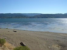
The Eel River is a major river, about 196 miles (315 km) long, in northwestern California. The river and its tributaries form the third largest watershed entirely in California, draining a rugged area of 3,684 square miles (9,540 km2) in five counties. The river flows generally northward through the Coast Ranges west of the Sacramento Valley, emptying into the Pacific Ocean about 10 miles (16 km) downstream from Fortuna and just south of Humboldt Bay. The river provides groundwater recharge, recreation, and industrial, agricultural and municipal water supply.

<span class="mw-page-title-main">Mokelumne River</span> River in northern California

The Mokelumne River is a 95-mile (153 km)-long river in northern California in the United States. The river flows west from a rugged portion of the central Sierra Nevada into the Central Valley and ultimately the Sacramento–San Joaquin River Delta, where it empties into the San Joaquin River-Stockton Deepwater Shipping Channel. Together with its main tributary, the Cosumnes River, the Mokelumne drains 2,143 square miles (5,550 km2) in parts of five California counties. Measured to its farthest source at the head of the North Fork, the river stretches for 157 miles (253 km).

<span class="mw-page-title-main">Friant Dam</span> Dam in Madera/Fresno Counties, California

Friant Dam is a concrete gravity dam on the San Joaquin River in central California in the United States, on the boundary of Fresno and Madera Counties. It was built between 1937 and 1942 as part of a U.S. Bureau of Reclamation (USBR) water project to provide irrigation water to the southern San Joaquin Valley. The dam impounds Millerton Lake, a 4,900-acre (2,000 ha) reservoir about 15 miles (24 km) north of Fresno.

<span class="mw-page-title-main">Colorado–Big Thompson Project</span> Federal water diversion project

The Colorado–Big Thompson Project is a federal water diversion project in Colorado designed to collect West Slope mountain water from the headwaters of the Colorado River and divert it to Colorado's Front Range and plains. In Colorado, approximately 80% of the state's precipitation falls on the West Slope, in the Rocky Mountains, while around 80% of the state's growing population lives along the eastern slope, between the cities of Fort Collins and Pueblo.

<span class="mw-page-title-main">California State Water Project</span> Flood control, energy production, and water conveyance infrastructure

The California State Water Project, commonly known as the SWP, is a state water management project in the U.S. state of California under the supervision of the California Department of Water Resources. The SWP is one of the largest public water and power utilities in the world, providing drinking water for more than 27 million people and generating an average of 6,500 GWh of hydroelectricity annually. However, as it is the largest single consumer of power in the state itself, it has a net usage of 5,100 GWh.

<span class="mw-page-title-main">Navajo Dam</span> Dam in San Juan and Rio Arriba Counties, New Mexico

Navajo Dam is a dam on the San Juan River, a tributary of the Colorado River, in northwestern New Mexico in the United States. The 402-foot (123 m) high earthen dam is situated in the foothills of the San Juan Mountains about 44 miles (71 km) upstream and east of Farmington, New Mexico. It was built by the U.S. Bureau of Reclamation (Reclamation) in the 1960s to provide flood control, irrigation, domestic and industrial water supply, and storage for droughts. A small hydroelectric power plant was added in the 1980s.

<span class="mw-page-title-main">Fryingpan–Arkansas Project</span>

The Fryingpan–Arkansas Project, or "Fry-Ark," is a water diversion, storage and delivery project serving southeastern Colorado. The multi-purpose project was authorized in 1962 by President Kennedy to serve municipal, industrial, and hydroelectric power generation, and to enhance recreation, fish and wildlife interests. Construction began in 1964 and was completed in 1981. The project includes five dams and reservoirs, one federal hydroelectric power plant, and 22 tunnels and conduits totaling 87 miles (140 km) in length. The Bureau of Reclamation, under the Department of the Interior built and manages the project.

<span class="mw-page-title-main">Lake Pillsbury</span> Reservoir in Lake County, California

Lake Pillsbury is a lake in the Mendocino National Forest of Lake County, California, created from the Eel River and Hull Mountain watershed by Scott Dam. Elevation is 1,818 ft (554 m) with 65 mi (105 km) of shoreline and covering 2,003 acres (811 ha). Activities in the Lake Pillsbury Recreation Area include powerboating, fishing, swimming, sailing, picnicking, hiking and hang gliding. There are two main access roads to the lake. At the north end of the lake is a small gravel airstrip. About 400 vacation cabins including National Forest Recreational Residences ring the lake.

<span class="mw-page-title-main">Bear River (Feather River tributary)</span> River in California, United States

The Bear River is a tributary of the Feather River in the Sierra Nevada, winding through four California counties: Yuba, Sutter, Placer, and Nevada. About 73 miles (117 km) long, the river flows generally southwest through the Sierra then west through the Central Valley, draining a narrow, rugged watershed of 295 square miles (760 km2).

<span class="mw-page-title-main">East Fork Russian River</span> River in California, United States

East Fork Russian River is a 15 mi (24 km) long tributary of the Russian River in Mendocino County, California artificially connected to the Eel River via an interbasin diversion at the Potter Valley Project hydroelectric facility. It forms in the north of Potter Valley, flows south through this valley, then southwest through a mountain pass to Lake Mendocino, an artificial reservoir that empties into Russian River. At one time Clear Lake to the east drained through Cold Creek then along the lower part of East Fork Russian River through Coyote Valley to the Russian River proper. A few hundred years ago a massive landslide blocked this channel, and Clear Lake found a new outlet to the Sacramento River.

<span class="mw-page-title-main">Mammoth Pool Dam</span> Dam in Fresno / Madera counties, California

Mammoth Pool Dam is a hydroelectric dam located on the San Joaquin River in the southern Sierra Nevada mountain range of California, about 45 miles (72 km) northeast of Fresno. It forms Mammoth Pool Reservoir and lies within the Sierra National Forest. The dam and reservoir were named after a large natural pool in the river that was once located above the present dam site.

<span class="mw-page-title-main">Rio Grande Project</span>

The Rio Grande Project is a United States Bureau of Reclamation irrigation, hydroelectricity, flood control, and interbasin water transfer project serving the upper Rio Grande basin in the southwestern United States. The project irrigates 193,000 acres (780 km2) along the river in the states of New Mexico and Texas. Approximately 60 percent of this land is in New Mexico. Some water is also allotted to Mexico to irrigate some 25,000 acres (100 km2) on the south side of the river. The project was authorized in 1905, but its final features were not implemented until the early 1950s.

Sonoma Water, formerly known as the Sonoma County Water Agency, maintains a water transmission system that provides naturally filtered Russian River water to more than 600,000 residents in portions of Sonoma County, California and Marin County, California. The Water Agency is a water wholesaler that sells potable water to nine cities and special districts that in turn sell drinking water to their residents. These cities and special districts are: the City of Santa Rosa, Rohnert Park, Cotati, Petaluma, Sonoma, the Town of Windsor, Valley of the Moon Water District, Marin Municipal Water District, and North Marin Water District.

<span class="mw-page-title-main">Lake Van Arsdale</span> Reservoir in Mendocino County, California

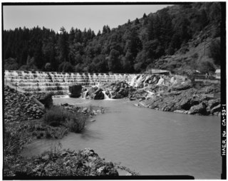
Lake Van Arsdale, also known as Van Arsdale Reservoir, is a reservoir on the Eel River in California, part of the Potter Valley Project. Located in Mendocino County, 4 miles (6.4 km) north of the town of Potter Valley, California, the reservoir supplies water to users as far south as Marin County.

<span class="mw-page-title-main">San Juan–Chama Project</span> Water management project in New Mexico and Colorado

The San Juan–Chama Project is a U.S. Bureau of Reclamation interbasin water transfer project located in the states of New Mexico and Colorado in the United States. The project consists of a series of tunnels and diversions that take water from the drainage basin of the San Juan River – a tributary of the Colorado River – to supplement water resources in the Rio Grande watershed. The project furnishes water for irrigation and municipal water supply to cities along the Rio Grande including Albuquerque and Santa Fe.

<span class="mw-page-title-main">Yuba–Bear Hydroelectric Project</span>

The Yuba–Bear Hydroelectric Project is a complex hydroelectric scheme in the northern Sierra Nevada in California, tapping the upper Yuba River and Bear River drainage basins. The project area encompasses approximately 400 square miles (1,000 km2) in Nevada, Placer, and Sierra Counties. Owned by the Nevada Irrigation District, it consists of 16 storage dams plus numerous diversion and regulating dams, and four generating stations producing 425 million kilowatt hours of electricity each year. The Yuba–Bear Hydroelectric Project consists of the Bowman development, Dutch Flat No. 2 development, Chicago Park development, and Rollins development.

<span class="mw-page-title-main">Upper North Fork Feather River Project</span>

The Upper North Fork Feather River Project is a hydroelectric scheme in the Sierra Nevada of California, within Lassen and Plumas Counties. The project consists of three dams, five power plants, and multiple conduits and tunnels in the headwaters of the North Fork Feather River, a major tributary of the Feather—Sacramento River systems. The total installed capacity is 362.3 megawatts (MW), producing an annual average of 1,171.9 gigawatt hours (GWh). The project is also contracted for the delivery of irrigation water between March 31 and October 31 of each year. The project is owned and operated by Pacific Gas and Electric Company.

References

  1. "Potter Valley Hydroelectric Project | Federal Energy Regulatory Commission (FERC) Project No. 77". California State Water Resources Control Board. Retrieved 1 December 2021.
  2. 1 2 3 4 "The Potter Valley Project". Potter Valley Irrigation District. Retrieved 2013-12-18.
  3. "Staff Report on the Russian River Watershed: Proposed Actions to be taken by the Division of Water Rights on Pending Water Right Applications within the Russian River Watershed" (PDF). California State Water Resources Control Board, Division of Water Rights. Klamath Resource Information System. 1997-08-15. Retrieved 2013-12-18.
  4. "PG&E Confirms Plan to Begin Full Removal of Eel River Dams". CalTrout. 2023-11-17. Retrieved 2024-01-30.
  5. "Potter Valley Project (FERC Project No. 77) Surrender Application and Decommissioning Plan". Pacific Gas & Electric Company. Retrieved 2024-01-30.
  6. Fishman, Kate (2023-12-11). "Decommissioning the Potter Valley Project: a turning point for Mendocino County". The Mendocino Voice. Retrieved 2024-01-30.
  7. "Potter Valley Project History".
  8. "Potter Valley Project (FERC No. 77) Project Overview". North Coast Integrated Regional Water Management Plan. 2001-09-21. Retrieved 2013-12-18.
  9. "Flows in the Eel River and the Potter Valley Project". Potter Valley Irrigation District. Retrieved 2013-12-18.
  10. "Potter Valley Irrigation District History". Potter Valley Irrigation District. Retrieved 2013-12-18.
  11. 1 2 Dixon, Roger (1995). "The Potter Valley Project, Part 1: Eel-Russian Flows". Mendocino Environmental Center. Retrieved 2013-12-18.
  12. "PG&E's Potter Valley Hydroelectric Project". Friends of the Eel River. Archived from the original on 2013-10-04. Retrieved 2013-12-18.