Powellville, Maryland

Last updated

Powellville
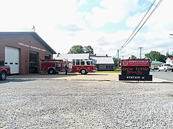
PowellvilleMDFireDepartment.jpg
Powellville Fire Department
USA Maryland location map.svg
Red pog.svg
Powellville
Location within the state of Maryland
Usa edcp location map.svg
Red pog.svg
Powellville
Powellville (the United States)
Coordinates: 38°19′43″N75°22′32″W / 38.32861°N 75.37556°W / 38.32861; -75.37556
CountryUnited States
State Maryland
County Wicomico
Area
[1]
  Total1.59 sq mi (4.11 km2)
  Land1.57 sq mi (4.08 km2)
  Water0.01 sq mi (0.03 km2)
Elevation
30 ft (9 m)
Population
 (2020)
  Total188
  Density119.44/sq mi (46.11/km2)
Time zone UTC−5 (Eastern (EST))
  Summer (DST) UTC−4 (EDT)
ZIP code
21852
Area code(s) 410 & 443
FIPS code 24-63725
GNIS feature ID591066 [2]

Powellville is an unincorporated community and census-designated place in Wicomico County, Maryland, United States. [2] Its population was 189 as of the 2010 census. [3] It is part of the Salisbury, Maryland-Delaware Metropolitan Statistical Area.

Demographics

Historical population
CensusPop.Note
2020 188
U.S. Decennial Census [4]

Related Research Articles

<span class="mw-page-title-main">Frederick County, Maryland</span> County in Maryland, United States

Frederick County is located in Maryland, United States. As of the 2020 U.S. census, the population was 271,717. The county seat is Frederick.

<span class="mw-page-title-main">Washington County, Maryland</span> County in Maryland, United States

Washington County is located in the western part of the U.S. state of Maryland. As of the 2020 census, the population was 154,705. It is the most populous county in the Western Maryland region and its county seat is Hagerstown.

<span class="mw-page-title-main">Wicomico County, Maryland</span> County in Maryland, United States

Wicomico County is located in the southeastern part of the U.S. state of Maryland, on the Delmarva Peninsula. As of the 2020 census, the population was 103,588. The county seat is Salisbury. The county was named for the Wicomico River, which in turn derives its name from the Algonquian language words wicko mekee, meaning "a place where houses are built," apparently referring to a Native American town on the banks. The county is included in the Salisbury, MD-DE Metropolitan Statistical Area.

<span class="mw-page-title-main">Severn, Maryland</span> Census-designated place in Maryland, United States

Severn is a census-designated place (CDP) in Anne Arundel County, Maryland, United States. According to the 2020 U.S. census, the population of Severn is 57,118, a 22.6% increase from 44,231 in 2010. The zip code is 21144.

<span class="mw-page-title-main">Berlin, Maryland</span> Town in Maryland, United States

Berlin is a town in Worcester County, Maryland, United States which includes its own historical Berlin Commercial District. The population was 4,485 at the 2010 census, and has since grown in population. It is part of the Salisbury, Maryland-Delaware Metropolitan Statistical Area.

<span class="mw-page-title-main">Calverton, Maryland</span> Census-designated place in Maryland, United States

Calverton is an unincorporated area and census-designated place located on the boundary between Montgomery and Prince George's counties, Maryland, in the United States. At the 2020 census, it had a population of 17,316.

<span class="mw-page-title-main">Hillandale, Maryland</span> Census-designated place in Maryland, United States

Hillandale is an unincorporated area and census-designated place located in Montgomery and Prince George's counties, Maryland, United States. As of the 2020 census, it had a population of 5,774. Hillandale is contained between the Prince George's / Montgomery County line to the east, the Anacostia River to the west, McCeney Avenue to the north, and D.C.'s Capital Beltway to the south. It borders the communities of Adelphi, Avenel, White Oak and Beltsville.

Lanham is an unincorporated community and census-designated place in Prince George's County, Maryland. As of the 2020 United States Census it had a population of 11,282. The New Carrollton station as well as an Amtrak station are across the Capital Beltway in New Carrollton, Maryland. Doctors Community Hospital is located in Lanham.

Peppermill Village is an unincorporated community near Maryland Route 214 in Prince George's County, Maryland, United States. Per the 2020 census, the population was 5,264. FedExField, Metrorail's Blue Line, and Hampton Mall shopping center are all located nearby. Because it is not formally incorporated, it has no official boundaries, but the United States Census Bureau has defined a census-designated place (CDP) consisting of Peppermill Village and the adjacent community of Carmody Hills, for statistical purposes.

<span class="mw-page-title-main">1790 United States census</span> First United States census

The 1790 United States census was the first decennial United States census of the whole United States. It recorded the population of the United States as of Census Day, August 2, 1790, as mandated by Article 1, Section 2 of the United States Constitution and applicable laws. In the first census, the population of the United States was enumerated to be 3,929,214 inhabitants

<span class="mw-page-title-main">1800 United States census</span> Second United States census conducted in the year 1800

The United States census of 1800 was the second census conducted in the United States. It was conducted on August 4, 1800. It showed that 5,308,483 people were living in the United States, of whom 893,602 were enslaved. The 1800 census included the new District of Columbia. The census for the following states were lost: Georgia, Kentucky, New Jersey, Tennessee, and Virginia.

<span class="mw-page-title-main">1830 United States census</span> Fifth US census

The United States census of 1830, the fifth census undertaken in the United States, was conducted on June 1, 1830. The only loss of census records for 1830 involved some countywide losses in Massachusetts, Maryland, and Mississippi.

The Salisbury, MD-DE Metropolitan Statistical Area is a United States Census Bureau-designated metropolitan area centered in and around Salisbury, Maryland, including four counties: Somerset, Wicomico, and Worcester in Maryland; and Sussex in Delaware.

<span class="mw-page-title-main">Green Sea, South Carolina</span> Census-designated place in South Carolina, United States

Green Sea is an unincorporated community and census-designated place (CDP) in Horry County, South Carolina, United States, near the city of Loris. It was first listed as a CDP in the 2020 census with a population of 105.

Konterra is an unincorporated area and census-designated place (CDP) in Prince George's County, Maryland, United States. The population was 3,158 at the 2020 census.

Cedarville is an unincorporated community and census-designated place in southern Prince George's County, Maryland, United States. As of the 2020 census the population was 639.

Melwood is an unincorporated community and census-designated place (CDP) in Prince George's County, Maryland, United States. It was newly delineated for the 2010 census, at which time its population was 3,051. Per the 2020 census, the population was 3,977.

Queensland is a census-designated place south of Upper Marlboro in Prince George's County, Maryland, United States. The population of the CDP was 2,191 at the 2020 census. It was formerly known as Queenland until 2014 when its name was changed to Queensland and a small portion of its geography was transferred to Upper Marlboro.

References

  1. "2020 U.S. Gazetteer Files". United States Census Bureau. Retrieved April 26, 2022.
  2. 1 2 "Powellville". Geographic Names Information System . United States Geological Survey, United States Department of the Interior.
  3. "U.S. Census website". United States Census Bureau . Retrieved May 14, 2011.
  4. "Census of Population and Housing". Census.gov. Retrieved June 4, 2016.