Powerline river crossings in the United Kingdom

Last updated

Powerline river crossings comprise both overhead lines and cable tunnels beneath rivers and estuaries. Overhead power lines are supported on towers (called pylons in the UK) which are usually significantly taller than overland pylons and are more widely spaced to cross the river in a single span. Tall pylons ensure that the electricity cables which they support provide an adequate safety clearance for river traffic.

Contents

Overhead crossings

The tallest and longest overhead power line river crossings in the United Kingdom are:


The tallest electricity pylons in the UK are those of the 400 kV Thames Crossing, at West Thurrock, which are 190 m (630 ft) high. These were constructed by BICC in 1965. The cables stretch 1300 m (4,500 ft) across the River Thames and have a minimum clearance of 76 m (250 ft). There are two 400 kV circuits that connect Littlebrook substation on the south bank to West Thurrock substation on the north side. [1]

The Aust Severn Powerline Crossing cables leaving this Aust pylon run for one mile to a similar pylon at Beachley Aust pylon of the Severn power line crossing, England arp.jpg
The Aust Severn Powerline Crossing cables leaving this Aust pylon run for one mile to a similar pylon at Beachley

The longest powerline river crossing in the UK is the Aust Severn Powerline Crossing over the River Severn at Aust, stretching 1700 m (5,310 ft) between towers 148 m (488 ft) high. The line was commissioned in 1959 and comprises two 275 kV electricity circuits forming part of the line between Iron Acton and Whitson substations. [2] This pylon crossing is paralleled by the Severn-Wye Cable Tunnel beneath it, at almost the same location.

List of overhead powerlines

This is an incomplete list of overhead powerline river crossings in the UK.

Overhead powerline river crossings in the UK
RiverLocationSpan (m)Height of towers (m)Clearance (m)NotesReferences
BlythBlyth, Northumberland389 (275 kV), 352 (66 kV)1 × double 275 kV, 1 × single 275 kV, 1 × double 66 kV, 1 × single 66 kV, 1 × single ? kV [3]
Cleddau DduBurton, Pembrokeshire5831 × single 132 kV [4]
ForthAlloa, Clackmannanshire425, 4622 × single 275 kV [5]
ForthKincardine Bridge, Clackmannanshire1,130137 & 1541 × single 275 kV, see 275 kV Forth Crossing [5]
LoughorBryn, Carmarthenshire and Swansea406 (upper crossing), 377 (lower)1 × single 132 kV, 1 × single 132 kV [6]
MerseyFiddlers Ferry, Warrington2501 × single 275 kV [7]
NessInverness, Highland1 × double 275 kV, 1 × double 132 kV,

1 × double 132 kV, 1 × double 33 kV

[8]
OrwellCliff Quay, Suffolk417 (upper), 444 (lower)452 × triple 132 kV (unusual triple circuit on each crossing) [9] [10] [11]
OuseBlacktoft, East Riding of Yorkshire5282 × double 400 kV [12]
RibblePreston, Lancashire2221 × double 400 kV, 1 × single 400 kV, 2 × double 132 kV, 1 × double 33 kV [13] [14]
SevernArlingham, Gloucestershire639 + 6392 × single 132 kV (crosses river twice) [15]
SevernAust, Gloucestershire1,7001481 × double 275 kV, commissioned in 1959, see Aust Severn Powerline Crossing
SoarCity of Leicester2653 × double 132 kV [16]
Tamar & TavyWeir Quay & Carr Green, Devon and Cornwall553 (400 kV), 635 (132 kV)1 × single 400 kV, 1 × double 132 kV [17]
Tay & EarnEaster Rhynd, Perth and Kinross425, 3801 × single 275 kV, 1 × single 132 kV [18]
TeesTeesport, Stockton on Tees5421 × single 400 kV [19]
ThamesThurrock, Essex and Littlebrook, Kent1,300190762 × double 400 kV. Constructed by BICC in 1965. See 400 kV Thames Crossing [1]
ThamesCrossness, Bexley & Dagenham, Barking and Dagenham933148.4Former 132 kV. Installed 1927-32, dismantled 1987. [20]
TrentWalcot, North Lincolnshire944 (upstream) 1022 (downstream)2 × double 400 kV [12]
TyneJarrow, Tyne and Wear8001281 × single 275 kV [21] [22] [23]
TyneStella, Tyne and Wear524 (longest crossing)1 × double 400 kV, 2 × double 275 kV, 2 × double 132 kV [24]
TywiPenken, Carmarthenshire359 (400 kV), 206 (132 kV)2 × double 400 kV, 1 × single 132 kV [25]
YareTrowse, Norwich, Norfolk72.5132 kV. Dismantled 2017 [26] [27]

Cable tunnel river crossings

In addition to overhead powerline river crossings, there are also underground powerline river crossings.

River Thames

Tunnels under the River Thames, from east to west are:

Cable tunnels under other rivers

Other underground tunnel cable crossings are:

Incidents

The 430-ft high 275kV Tyne Crossing collapsed on 16 February 1962, on the same day there was the British highest wind speed of 177mph on Lowther Hill in south-west Scotland. [38] [39] [40] The pylon at Jarrow crashed at 4am, and the pylon at East Howdon crashed at 5.20am. The Jarrow pylon crashed onto oil pipes of the neighbouring Shell oil terminal. The North Eastern Electricity Board had planned a transmission line from Blyth to Teesside in 1958; Jarrow Borough Council wanted the cables to go underground. [41]

It was part of the 50-mile Blyth to Lackenby 275kV line. [42] The transmission line was built around December 1961. [43] The crossing was rebuilt from 4 November 1962. [44]

Related Research Articles

<span class="mw-page-title-main">Transmission tower</span> Structure used to support an overhead power line

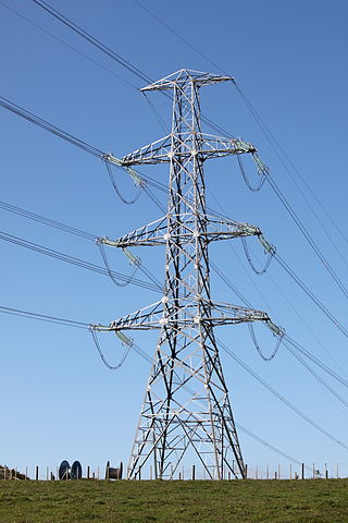
A transmission tower is a tall structure, usually a lattice tower made of steel that is used to support an overhead power line. In electrical grids, transmission towers carry high-voltage transmission lines that transport bulk electric power from generating stations to electrical substations, from which electricity is delivered to end consumers; moreover, utility poles are used to support lower-voltage sub-transmission and distribution lines that transport electricity from substations to electricity customers.

<span class="mw-page-title-main">Baltic Cable</span>

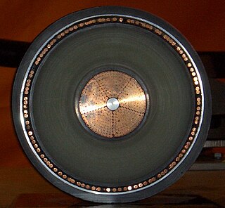
The Baltic Cable is a monopolar HVDC power line running beneath the Baltic Sea that interconnects the electric power grids of Germany and Sweden. Its maximum transmission power is 600 megawatts (MW).

<span class="mw-page-title-main">Pylons of Messina</span> Historic high-voltage towers in Italy

The Pylons of Messina are two free-standing steel towers, the Sicilian one in Torre Faro and the Calabrian one in Villa San Giovanni. They were used from 1955 to 1994 to carry a 220 kilovolt power line across the Strait of Messina, between the Scilla substation in Calabria on the Italian mainland at 38°14′42″N15°40′59″E and the Messina-Santo substation in Sicily at 38°15′57″N15°39′04″E.

<span class="mw-page-title-main">Overhead line crossing</span> Crossing of an immovable obstacle by an overhead power line

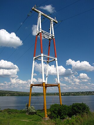
An overhead line crossing is the crossing of an obstacle—such as a traffic route, a river, a valley or a strait—by an overhead power line. The style of crossing depends on the local conditions and regulations at the time the power line is constructed. Overhead line crossings can sometimes require extensive construction and can also have operational issues. In such cases, those in charge of construction should consider whether a crossing of the obstacle would be better accomplished by an underground or submarine cable.

<span class="mw-page-title-main">Dead-end tower</span> Structure used in construction of overhead power lines

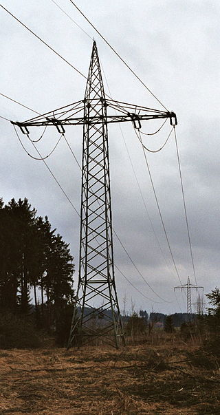
A dead-end tower is a fully self-supporting structure used in construction of overhead power lines. A dead-end transmission tower uses horizontal strain insulators at the end of conductors. Dead-end towers may be used at a substation as a transition to a "slack span" entering the equipment, when the circuit changes to a buried cable, when a transmission line changes direction by more than a few degrees, or at intervals along a straight run to limit the extent of a catastrophic collapse.

<span class="mw-page-title-main">Overhead power line</span> Above-ground structure for bulk transfer and distribution of electricity

An overhead power line is a structure used in electric power transmission and distribution to transmit electrical energy along large distances. It consists of one or more conductors suspended by towers or poles. Since the surrounding air provides good cooling, insulation along long passages and allows optical inspection, overhead power lines are generally the lowest-cost method of power transmission for large quantities of electric energy.

<span class="mw-page-title-main">Berlin 380-kV electric line</span>

The Berlin 380 kV electric line is a 38.3-km double-circuit high-voltage electric three-phase power line in Berlin. An unusual system for a municipality, it was installed by the West Berlin Bewag utility company during the division of the city. Since 1951, West Berlin had been cut off from the East Berlin and East German power networks, and maintained an independent power generation capacity that was not connected to any other power grid. Berlin was connected to the western European power grid in 1994, following German reunification, by extending the 380 kV line.

<span class="mw-page-title-main">Traction power network</span> Electricity grid for the supply of electrified rail networks

A traction network or traction power network is an electricity grid for the supply of electrified rail networks. The installation of a separate traction network generally is done only if the railway in question uses alternating current (AC) with a frequency lower than that of the national grid, such as in Germany, Austria and Switzerland.

The Yangtze River power line crossings are overhead power lines that cross the Yangtze River in China. There are at least three power line crossings on the Yangtze River at Jiangyin, Nanjing, and Wuhu. The towers of the crossing in Jiangyin are among the highest in the world.

<span class="mw-page-title-main">400 kV Thames Crossing</span> Overhead power line crossing of the River Thames

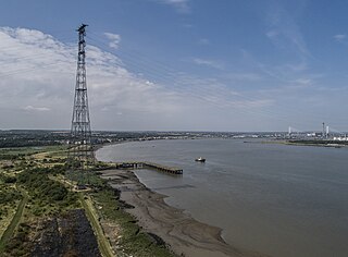
The 400 kV Thames Crossing is an overhead power line crossing of the River Thames, between Botany Marshes in Swanscombe, Kent, and West Thurrock, Essex, England. Its towers are the tallest electricity pylons in the UK.

<span class="mw-page-title-main">Aust Severn Powerline Crossing</span> Power line span over the River Severn in Great Britain

Aust Severn Powerline Crossing is the longest overhead power line span in the United Kingdom with a length of 1,618 m (5,308 ft).

<span class="mw-page-title-main">GKK Etzenricht</span>

GKK Etzenricht, an abbreviation of Gleichstromkurzkupplung Etzenricht, meaning Etzenricht HVDC-back-to-back station, was an HVDC back-to-back facility near Etzenricht in the district of Neustadt an der Waldnaab in Bavaria, Germany. It was built on the site of the Etzenricht substation, a 380 kV/220 kV/110 kV-substation, which went into service in 1970 and expanded afterwards several times. The facility was used between 1993 and 1995 for the exchange of power between Germany and the Czech Republic, operated by Bayernwerk AG.

<span class="mw-page-title-main">275 kV Forth Crossing</span>

The 275 kV Forth Crossing is an overhead power line crossing of the River Forth in Scotland. The crossing, located next to the Clackmannanshire Bridge and the Kincardine Bridge, has the tallest electricity towers (pylons) in Scotland.

The Saint Lawrence River HVDC Powerline Crossing is the crossing of Hydro-Québec's Quebec-New England HVDC transmission line over the Saint Lawrence River between Grondines and Lotbinière, Quebec, Canada. The crossing is remarkable, for being first implemented as an overhead crossing, and then later replaced by a cable tunnel. Hydro-Québec wanted to complete the transmission line in time, which was only possible with an overhead crossing of Saint Lawrence River. However, due to the negative visual impact of the large towers of the overhead crossing on the local populations of Grondines and Lotbinière, it was decided to build a cable tunnel under the river, although this made the project more expensive.

<span class="mw-page-title-main">Whakamaru to Brownhill Road transmission line</span>

The Whakamaru to Brownhill Road transmission line is a double-circuit 400 kV-capable transmission line constructed by Transpower to increase the capacity of the National Grid between the southern Waikato and the city of Auckland. The line runs from the Whakamaru sub-station near the Whakamaru Power Station, over a distance of 186 kilometres (116 mi) to the new Brownhill Road substation near Whitford in southeastern Auckland. The line will initially be operated at 220 kV. From Brownhill Road, 220 kV underground cables connect the line to the Pakuranga sub-station in eastern Auckland. The project was the subject of considerable controversy and protest during the planning and approval stages. Construction of the line started in February 2010, and the line was commissioned on 30 October 2012. The transmission line forms the major part of a wider North Island Grid Upgrade project with a forecast cost to completion of $894 million.

<span class="mw-page-title-main">Fawley Tunnel</span> Power cable tunnel in Hampshire, England

Fawley Tunnel, or Fawley transmission tunnel, is a 3-metre (9.8 ft) diameter, 2-mile (3.2 km) long tunnel under Southampton Water between Fawley Power Station and Chilling near Warsash. It carries the cables of two 400kV circuits of the National Grid.

The Thames Cable Tunnel, also known as the Tilbury – Gravesend Cable Tunnel, is a tunnel carrying high-voltage electrical transmission lines beneath the lower River Thames between Tilbury and Gravesend. It remains the furthest tunnel downstream on the Thames.

The Lower Lea Valley Cable Tunnels, known as the PLUG Project during construction, are a pair of 6 km cable tunnels running beneath the lower Lea Valley in east London. Constructed at a cost of £130m ahead of the 2012 London Olympic Games, they are owned by National Grid plc and UK Power Networks.

The River Medway Cable Tunnels are a pair of tunnels carrying high-voltage electricity transmission lines beneath the lower River Medway between the Isle of Grain and Chetney Marshes, Kent.

The Severn-Wye Cable Tunnel, also known as the Severn Cable Tunnel, carries high-voltage electricity transmission lines beneath the estuaries of the River Severn and River Wye between Newhouse (Mathern), Monmouthshire and Aust, South Gloucestershire.

References

  1. 1 2 "Open Infrastructure Map". Open Infrastructure Map. Retrieved 20 March 2020.
  2. "Open Infrastructure Map". Open Infrastructure Map. Retrieved 20 March 2020.
  3. "Open Infrastructure Map".
  4. "Open Infrastructure Map" . Retrieved 30 July 2020.
  5. 1 2 "Open Infrastructure Map".
  6. "Open Infrastructure Map" . Retrieved 30 July 2020.
  7. "Open Infrastructure Map".
  8. "Open Infrastructure Map".
  9. "Open Infrastructure Map".
  10. "Find my harbour". Visit my harbour. Retrieved 30 July 2020.
  11. "Ipswich Docks and National Grid electricity pylons & cables spanning the River Orwell". alamy. Retrieved 1 August 2020.
  12. 1 2 "Open Infrastructure Map".
  13. "Open Infrastructure Map". Open Infrastructure Map. Retrieved 11 April 2020.
  14. "Navigations in the north west". Canal Enthusiast. 2010. Retrieved 11 April 2020.
  15. "Open Infrastructure Map" . Retrieved 30 July 2020.
  16. "Open Infrastructure Map".
  17. "Open Infrastructure Map" . Retrieved 30 July 2020.
  18. "Open Infrastructure Map".
  19. "Open Infrastructure Map" . Retrieved 30 July 2020.
  20. "Power over the Thames". Wonders of World Engineering. 11 January 1938. Retrieved 23 March 2020.
  21. "Harbours".
  22. "Open Infrastructure Map". Open Infrastructure Map. Retrieved 20 March 2020.
  23. Span measured on map
  24. "Open infrastructure Map".
  25. "Open Infrastructure Map" . Retrieved 30 July 2020.
  26. "Planning Application - Utilities site Norwich". norwich.gov.uk. 3 September 2015. Retrieved 7 April 2020.
  27. "Fifteen pylons and 4.5km of overhead lines to be removed from Norwich skyline". Eastern Daily Press. 26 May 2017. Retrieved 7 April 2020.
  28. "Open Infrastructure Map". Open Infrastructure Map. Retrieved 23 March 2020.
  29. "Open Infrastructure Map". Open Infrastructure Map. Retrieved 23 March 2020.
  30. "Open Infrastructure Map". Open Infrastructure Map. Retrieved 20 March 2020.
  31. 1 2 "Open Infrastructure Map". Open Infrastructure Map. Retrieved 20 March 2020.
  32. 1 2 "Open Infrastructure Map". Open Infrastructure Map. Retrieved 20 March 2020.
  33. "Open Infrastructure Map". Open Infrastructure Map. Retrieved 20 March 2020.
  34. "Open Infrastructure Map". Open Infrastructure Map. Retrieved 20 March 2020.
  35. "Open Infrastructure Map". Open Infrastructure Map. Retrieved 20 March 2020.
  36. "Open Infrastructure Map". Open Infrastructure Map. Retrieved 23 March 2020.
  37. "Open Infrastructure Map". Open Infrastructure Map. Retrieved 20 March 2020.
  38. Newcastle Evening Chronicle Friday 16 February 1962, page 1
  39. Newcastle Journal Saturday 17 February 1962, page 11
  40. Times Saturday February 17 1962, page 8
  41. Newcastle Evening Chronicle Thursday 5 June 1958, page 7
  42. Newcastle Evening Chronicle Thursday 23 June 1960, page 3
  43. Newcastle Evening Chronicle Tuesday 1 May 1962, page 5
  44. Newcastle Evening Chronicle Monday 5 November 1962, page 5