In digital photography, computer-generated imagery, and colorimetry, a grayscale or greyscale image is one in which the value of each pixel is a single sample representing only an amount of light, that is, it carries only intensity information. Grayscale images, a kind of black-and-white or gray monochrome, are composed exclusively of shades of gray. The contrast ranges from black at the weakest intensity to white at the strongest.

sRGB is an RGB color space that HP and Microsoft created cooperatively in 1996 to use on monitors, printers, and the Internet. It was subsequently standardized by the IEC as IEC 61966-2-1:1999. It is often the "default" color space for images that contain no color space information, especially if the images' pixels are stored in 8-bit integers per color channel.
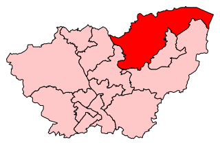
Doncaster North is a constituency in South Yorkshire represented in the House of Commons of the UK Parliament since 2005 by Ed Miliband of the Labour Party.

Mahoba district is one of the districts of Uttar Pradesh state of India and Mahoba town is the district headquarters. Mahoba district is a part of Chitrakoot Division. The district occupies an area of 2884 km². It has a population of 876,055. As of 2011 it is the least populous district of Uttar Pradesh .2 Mahoba District also known as Alha-Udal Nagari.

Howe is a neighborhood within the larger Longfellow community in Minneapolis. It is bordered by the Cooper and Longfellow neighborhoods to the north, Corcoran and Standish to the west, Hiawatha to the south, and the Mississippi River to the east. The neighborhood and its elementary school are named for Julia Ward Howe.

The Golden Mile is the name given to the stretch of Promenade between the North and South piers in Blackpool, England. It emerged in the late 19th century, when small-time amusement ride operators, fortune-tellers, phrenologists and oyster bars set up in the front gardens of boarding houses, to take advantage of passing trade near the now-demolished Blackpool Central railway station.
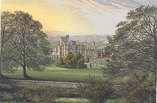
Ilam Park is a 158-acre (0.64 km2) country park situated in Ilam, on both banks of the River Manifold five miles (8 km) north west of Ashbourne, England, and in the ownership of the National Trust. The property is managed as part of the Trust's White Peak Estate.
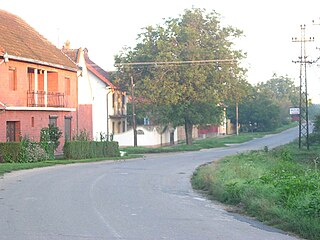
Zagajica is a village in Serbia. It is situated in the Vršac municipality, in the South Banat District, Vojvodina province. The village has a Serb ethnic majority (89.21%) and its population numbering 492 people.

Dropshort Marsh is a 2.7 hectare biological Site of Special Scientific Interest in Toddington in Bedfordshire. It was notified under Section 28 of the Wildlife and Countryside Act 1981 in 1985, and the local planning authority is Central Bedfordshire Council. The site is managed by the Wildlife Trust for Bedfordshire, Cambridgeshire and Northamptonshire.
Tybory-Żochy is a village in the administrative district of Gmina Wysokie Mazowieckie, within Wysokie Mazowieckie County, Podlaskie Voivodeship, in north-eastern Poland.
Bârna is a commune in Timiș County, Romania. It is composed of seven villages: Bârna, Botești (Borzasfalva), Botinești (Bottyánfalva), Drinova (Derenyő), Jurești (Györösd), Pogănești (Pogányfalva) and Sărăzani (Szárazány).

Dźwierzno is a village in the administrative district of Gmina Bieżuń, within Żuromin County, Masovian Voivodeship, in east-central Poland. It lies approximately 4 kilometres (2 mi) east of Bieżuń, 14 km (9 mi) south of Żuromin, and 109 km (68 mi) north-west of Warsaw.

Silno is a village in the administrative district of Gmina Chojnice, within Chojnice County, Pomeranian Voivodeship, in northern Poland. It lies approximately 12 kilometres (7 mi) south-east of Chojnice and 101 km (63 mi) south-west of the regional capital Gdańsk.
Hořany is a village and municipality in Nymburk District in the Central Bohemian Region of the Czech Republic.
Zalaszántó is a village in Zala County, Hungary. It is home to a large Buddhist stupa.

The Baltic International Academy is the largest degree-awarding tertiary educational institution in Latvia teaching primarily in the Russian language and the largest non-government higher education establishment in the Baltic countries. It was established in 1992 as the Baltic Russian Institute. It adopted its current name in 2006. The academy has its main campus in Riga and has locations in Daugavpils, Liepāja, Rēzekne, Jēkabpils, Ventspils, Smiltene and Jelgava. It has 4,500 students, including 450 foreign students from 15 countries.

Cartwright Air Station is a closed General Surveillance Radar station. It is located 145.2 miles (233.7 km) east-northeast of CFB Goose Bay, Newfoundland and Labrador. It was closed in 1968.
Fereydunkenar County is a county in Mazandaran Province in Iran. The capital of the county is Fereydunkenar. It was separated from Babolsar County in 2008. At the 2006 census, the county's population was 56,055, in 15,049 families. The county has two districts: the Central District and Dehferi District. The county has one city: Fereydunkenar.

Alderman Canal West is a one hectare Local Nature Reserve in Ipswich in Suffolk. It is owned by Ipswich Borough Council and managed by the Greenways Project.

Waldringfield Pit is a 0.8 hectare geological Site of Special Scientific Interest between Martlesham Heath and Waldringfield in Suffolk. It is a Geological Conservation Review site.


