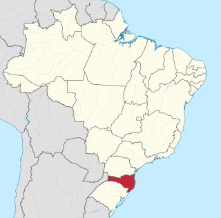
Santa Catarina is one of the 27 federative units of Brazil. It is located in the centre of the country's Southern region. It is bordered to the north by the state of Paraná, to the south by the state of Rio Grande do Sul, to the east by the Atlantic Ocean, and to the west by the Argentine province of Misiones.

Florianópolis is the capital and second largest city of the state of Santa Catarina, in the South region of Brazil. The city encompasses Santa Catarina Island and surrounding small islands, as well as part of the mainland. It has a population of 537,211, according to the 2022 Brazilian census, the second-most populous city in the state, and the 39th in Brazil. The metropolitan area has an estimated population of 1,111,702, the 21st largest in the country. The city is known for having the country's third highest Human Development Index score among all Brazilian cities (0.847).

Laguna is a Brazilian municipality located in the southern state of Santa Catarina, 120 kilometers south of the state's capital, Florianópolis, and north east of Porto Alegre. The population is 46,122 in an area of 336.4 km². Elevation is 2 m. The BR-101 coastal highway passes through the municipality.

Palhoça is a municipality in Santa Catarina, Brazil.

Santa Catarina Island is an island in the Brazilian state of Santa Catarina, located off the southern coast. It is home to the state capital, Florianópolis.

Balneário Camboriú is a coastal city in the southern Brazilian state of Santa Catarina. The city is built on steep hills which drop down to the sea. It is a popular tourist destination for South Americans, who are drawn to its main ocean boulevard Avenida Atlântica, and who swell the city's population from 145,796 to over one million in the summer. Balneário Camboriú is famous for its unique beach-to-beach cable car which links the city's central beach with the beach of Laranjeiras. The city is located 10 km (6.2 mi) south of the city of Itajaí, 96 km (60 mi) south of the city of Joinville, and 80 km (50 mi) north of the state capital, Florianópolis.
Barra da Lagoa is a small fishing village in the city of Florianópolis, Santa Catarina, Brazil. The village is set on the mouth of a tidewater channel that flows in and out of the Island's sizable lagoon, the Lagoa da Conceição. The channel is at the end of a long beach made up of Praia Barra da Lagoa and Mozambique Beach which form a single 14 km stretch of beach.

Tourism is a growing sector and key to the economy of several regions of Brazil. The country had 6.589 million visitors in 2018, ranking in terms of the international tourist arrivals as the second main destination in South America after Argentina and third in Latin America after Mexico and Argentina. Revenues from international tourists reached US$5.8 billion in 2015, continuing a recovery trend from the 2008–2009 economic crisis.

The coastline of Brazil measures 7,491 km, making it the 16th longest national coastline in the world. The coastline touches exclusively the Atlantic Ocean. Brazil's coastline has many geographical features such as islands, reefs, bays, and its 2,095 beaches.

São Miguel do Oeste is a Brazilian municipality in the state of Santa Catarina, in the southern region of Brazil, 655 km from the state capital, Florianópolis. Its population in 2022, according to the Brazilian Institute of Geography and Statistics Demographic Census, was 44 330 inhabitants.
Ingleses do Rio Vermelho is a district of Florianópolis located in the northeast of the island of Santa Catarina, between the districts of Cachoeira do Bom Jesus and São João do Rio Vermelho, created by a decree in 1831. The origin of its name is attributed to the sinking of an English ship, occurring in the mid-eighteenth century, when some crew members opted to reside in the region.
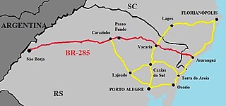
BR-285 is an east-west Brazilian federal highway that starts in Araranguá, Santa Catarina, and crosses the Gaucho range and highlands. It stretches approximately 674.5 km, passing through cities such as Vacaria, Lagoa Vermelha, Passo Fundo, Carazinho, Ijuí e São Luiz Gonzaga, and ends in São Borja, Rio Grande do Sul, on the border of Argentina.
Praia dos Açores is a beach-side district on the south side of the Island of Santa Catarina in the state of Santa Catarina in Brazil. The beach is 31 km from the Centro downtown region of Florianópolis.

Mozambique Beach is the longest beach on Santa Catarina Island in Brazil at 13.5 km in length. The beach is located to the north of Barra da Lagoa in the east of the island.

Praia de Naufragados is a beach on Santa Catarina Island in Florianópolis, Santa Catarina, Brazil. The beach is 1.45 km in length and is only accessible by a 4 km walking trail.

Praia Brava is a beach located at the northern end of the island of Santa Catarina Island, between Praia da Lagoinha and Praia dos Ingleses, 38 kilometres (24 mi) from the center of Florianópolis, capital of the State of Santa Catarina, and is one of the most beautiful beaches in this city.
Serra do Tabuleiro State Park is a state park in the state of Santa Catarina, Brazil. It protects a mountainous area near the city of Florianópolis, covered in Atlantic Forest, which is an important source of drinking water. It also protects some coastal islands. The park is used for scientific research, education and eco-tourism.

The island of Santiago in Cape Verde in the middle of the Sotavento Islands is home to several teams and clubs. The major professional clubs are Sporting Praia, Boavista Praia and CD Travadores, semi-pro teams includes Académica da Praia and Desportivo da Praia. From its foundation in 1953 to 1999, the island had a single league of each sport. Since that time, the association and competition are currently divided into two zones, the north and the south and includes all sports including football, basketball, volleyball, futsal and athletics, the only island to have nearly all the sport competitions into two zones.

The Rio Vermelho State Park Portuguese: Parque Estadual do Rio Vermelho is a state park in the state of Santa Catarina, Brazil. It protects an area of restinga, dense rainforest and land modified by exotic plantations which is to be restored. The park provides a green space for visitors from the nearby state capital of Florianópolis. It features an ecological trail where visitors may see and learn about wild animals rescued from abuse by the environmental police.
