Related Research Articles

Regina is the capital city of the Canadian province of Saskatchewan. The city is the second-largest in the province, and is a commercial centre for southern Saskatchewan. As of the 2021 census, Regina had a city population of 226,404, and a metropolitan area population of 249,217. It is governed by Regina City Council. The city is surrounded by the Rural Municipality of Sherwood No. 159.
Saskatoon Public Schools (SPS) or Saskatoon S.D. No. 13 is the largest school division in Saskatchewan serving 28,246 students as of September 2023. Saskatoon Public Schools operates 48 elementary schools and 10 secondary schools in Saskatoon. The offices of the Saskatoon School Board are housed in the Eaton's Building. Saskatoon School Division No. 13 belongs to Department of Saskatchewan Learning Division 4 along with Englefeld Protestant Separate School Division No. 132, Horizon School Division No. 205, Prairie Spirit School Division No. 206, St. Paul's Roman Catholic Separate School Division No. 20, Sun West School Division No. 207 and Division scolaire francophone 310.
Melfort is a city in Saskatchewan, Canada, located approximately 95 kilometres (59 mi) southeast of Prince Albert, 172 kilometres (107 mi) northeast of Saskatoon and 280 kilometres (170 mi) north of Regina.

Indian Head is a town in southeast Saskatchewan, Canada, 69 kilometres (43 mi) east of Regina on the Trans-Canada Highway. It "had its beginnings in 1882 as the first settlers, mainly of Scottish origin, pushed into the area in advance of the railroad, most travelling by ox-cart from Brandon." "Indian" refers to Indigenous peoples in Canada. The town is known for its federally operated experimental farm and tree nursery, which has produced and distributed seedlings for shelter belts since 1901. For many years the program was run by the Prairie Farm Rehabilitation Administration (PFRA).

Delisle is a town in south central Saskatchewan, Canada. It is 45 kilometres (28 mi) southwest of Saskatoon beside Highway 7.

Dalmeny is a town in the central part of Saskatchewan, Canada, named after Dalmeny, Scotland. The town is located in the Rural Municipality of Corman Park No. 344, and is about 26.8 km north of Saskatoon. The Dominion Land Survey description of Dalmeny's location is Section 10 Twp 39 Rge 6 W3.
Martensville is a city located in Saskatchewan, Canada, just 8 kilometres (5.0 mi) north of Saskatoon, 10 kilometres (6.2 mi) west of the city of Warman and 14 kilometres (8.7 mi) southwest of Clarkboro Ferry which crosses the South Saskatchewan River. It is a bedroom community of Saskatoon. It is surrounded by the Rural Municipality of Corman Park No. 344. The community is served by the Saskatoon/Richter Field Aerodrome located immediately west of the city across Highway 12, as well as by Saskatoon's John G. Diefenbaker International Airport, only a few miles to the south.

Grenfell is a town in Southern Saskatchewan, Canada. It is situated at the junction of Highway 47 and the Trans-Canada Highway 1 130 kilometres (80 mi) east of Regina, the provincial capital. It is 24 kilometres (15 mi) south of the Qu'Appelle Valley where Crooked Lake Provincial Park and Bird's Point Resort are popular beach destinations and are accessed by Highway 47.
Qu'Appelle is a town in Saskatchewan, located on Highway 35 approximately 50 kilometres (31 mi) east of the provincial capital of Regina.

Blaine Lake is a town in central Saskatchewan, Canada. It is located 85 km north of Saskatoon, 104 km southwest of Prince Albert and 104 km east of North Battleford at the junction of Highway 12 and Highway 40. Nearby are the urban centres of Shellbrook and Rosthern. Blaine Lake is considered the "Gateway to the Northern Lakes" due to its proximity to fishing, hunting and camping sites, as well as its convenient location at a junction of two highways.
Located in west-central Saskatchewan, the Sun West School Division covers approximately 25,600 square kilometers. On its east side, the Division includes schools in Davidson and Kenaston, whose attendance areas include students on the east side of Highway 11. The Alberta border serves as the Division's limits on the west, with the South Saskatchewan River providing its most southerly border. The Division extends as far north as Landis and Biggar. Sun West School Division No. 207 belongs to Department of Saskatchewan Learning Division 4 along with Englefeld Protestant Separate S.D. No. 132, Horizon School Division No. 205, Prairie Spirit School Division No. 206, Saskatoon School Division No. 13, Greater Saskatoon Catholic School Division - and Division scolaire francophone 310.
Highway 1 is the Saskatchewan section of the Trans-Canada Highway mainland route. The total distance of the Trans-Canada Highway in Saskatchewan is 654 kilometres (406 mi). The highway traverses Saskatchewan from the western border with Alberta, from Highway 1, to the Manitoba border where it continues as PTH 1. The Trans-Canada Highway Act was passed on December 10, 1949. The Saskatchewan segment was completed August 21, 1957, and completely twinned on November 6, 2008. The speed limit along the majority of the route is 110 kilometres per hour (70 mph) with urban area thoroughfares slowing to a speed of 80–100 kilometres per hour (50–62 mph). Portions of the highway—the section through Swift Current, an 8-kilometre (5 mi) section east of Moose Jaw, and a 44-kilometre (27 mi) section between the West Regina Bypass and Balgonie—are controlled-access. Highway 1 serves as a major east–west transport route for commercial traffic. It is the main link between southern Saskatchewan's largest cities, and also serves as the province's main link to the neighbouring provinces of Alberta and Manitoba.

Maple Creek is a town in the Cypress Hills of southwest Saskatchewan, Canada. It is surrounded by the Rural Municipality of Maple Creek No. 111. The population was 2,176 at the 2021 Census.
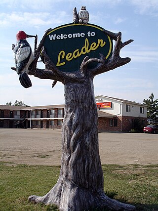
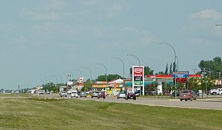
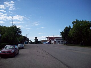
Leader is a town in southwestern Saskatchewan, Canada, located approximately 350 kilometres (220 mi) directly east of Calgary, Alberta and is near the border between Saskatchewan and Alberta. It has a population of 863 as of 2016.
Highway 11 is a major north-south highway in Saskatchewan, Canada that connects the province's three largest cities: Regina, Saskatoon, and Prince Albert. It is a structural pavement major arterial highway which is approximately 391 kilometres (243 mi) long. It is also known as the Louis Riel Trail (LRT) after the 19th century Métis leader. It runs from Highway 1 in Regina until Highway 2 south of Prince Albert. Historically the southern portion between Regina and Saskatoon was Provincial Highway 11, and followed the Dominion Survey lines on the square, and the northern portion between Saskatoon and Prince Albert was Provincial Highway 12.
Highway 6 is a paved undivided major provincial highway in the Canadian province of Saskatchewan. It runs from Montana Highway 16 at the Canada–US border near the Canada customs port of Regway to Highway 55 near Choiceland. Highway 6 is about 523 km (325 mi) long. The CanAm Highway comprises Saskatchewan Highways from south to north: SK 35, Sk 39, Sk 6, Sk 3, as well as Sk 2. 330 kilometres (210 mi) of Saskatchewan Highway 6 contribute to the CanAm Highway between Corinne and Melfort.

Broadview is a town in Saskatchewan along Highway 1, the Trans-Canada Highway, about 155 kilometres (96 mi) east of Regina. The local economy is based mainly on agriculture. It is also the administrative headquarters of the Rural Municipality of Elcapo No. 154
Lang is a village in the Canadian province of Saskatchewan within the Rural Municipality of Scott No. 98 and Census Division No. 2. The village is located approximately 70 km southeast of the City of Regina.
References
- 1 2 Prairie Valley School Division school profiles, archived from the original on 2008-12-24, retrieved 2008-12-21
- ↑ Section 7: Saskatchewan School Divisions, archived from the original on 2010-02-20, retrieved 2008-12-21
- ↑ Saskatchewan schools and school divisions, archived from the original on 2008-12-10, retrieved 2008-12-21
- ↑ Untitled Saskatchewan Schools and School Divisions Region 1, archived from the original on 2006-10-04, retrieved 2008-12-21