
Bhojpur is one of the two urban municipalities of Bhojpur District of Province No. 1 of Nepal.

Dharan is a sub-metropolitan city in Sunsari District of Province No. 1, Nepal, which was established as a fourth municipality in the Kingdom in 1958. It is the third most populous city in Eastern Nepal after Biratnagar and Itahari. Dharan is the location of the former Vijayapur, the seat of a historical Limbuwan kingdom, which was later used by the Sen kings of Makwanpur. Dharan has an estimated city population of 173,096 living in 34,834 households as per 2021 Nepal census. It is one of the cities of the Greater Birat Development Area which incorporates the cities of Biratnagar-Itahari-Gothgau-Biratchowk-Dharan primarily located on the Koshi Highway in Eastern Nepal, with an estimated total urban agglomerated population of 804,300 people living in 159,332 households. It is the largest city in the province number one by Area. It covers 192.32 square kilometers while Biratnagar and Itahari is 2nd and 3rd biggest cities by Area

Sunsari District is one of 14 districts in Province No. 1 of Nepal. The district is located in the eastern part of the Outer Terai and covers an area of 1,257 km2 (485 sq mi).

Udayapur District (Nepali: उदयपुर जिल्लाListen , is one of 14 districts of Province No. 1 of eastern Nepal. The district, with Triyuga as its district headquarters, covers an area of 2,063 km2 and in 2001 had a population of 287,689, in 2011 of 317,532, in 2021 of 342,773

Kosi or Koshi was one of the fourteen zones of Nepal until the restructure of zones to provinces. The headquarters of Kosi Zone was Biratnagar which was also its largest city. Other cities of Kosi Zone were Inaruwa, Dharan, Dhankutta, Jhumka, Duhabi and Itahari. Its main rivers were Arun, Tamor and Sapta Koshi.

Butwal, officially Butwal Sub-Metropolitan City, is a sub-metropolitan city and economic hub in Lumbini Province in West Nepal. Butwal has a city population of 195,054 as per 2021 Nepal census.

Inaruwa is a municipality and headquarters of Sunsari District located 25 km (16 mi) east of the Koshi Barrage and 18.6 km (11.6 mi) east of Koshi Tappu Wildlife Reserve in Province No. 1, Nepal. It covers an area of 77.92 km2 (30.09 sq mi).
Ghorahi is the seventh largest city and largest sub-metropolitan city of Nepal. The city lies in Lumbini Province in the Mid-Western part of Nepal. It is the largest city of Dang Deukhuri District of southwest Nepal. Located in the Inner Terai region, it lies 413 kilometres (257 mi) south-west of Nepal's capital Kathmandu and is one of the Counter Magnets being developed as an alternative centre of growth to help ease the migration and population explosion in the Kathmandu metropolitan area. It is the largest city of the Rapti Zone and is surrounded by the Sivalik Hills to the south and Mahabharata Range to the north.
Itahari is a sub-metropolitan city in the Sunsari District of Province No. 1 of Nepal. Itahari city is business hub of eastern Nepal. It is the second most populous city in Eastern Nepal after Biratnagar. Situated at a distance of 25 kilometres north of the provincial capital of Biratnagar, 16 kilometres south of Dharan and 92 kilometres west of Kakarbhitta, Itahari serves as a junction point of the east-west Mahendra highway and the north–south Koshi highway. Itahari has an estimated city population of 1,98,098 living in 40,207 households as per 2021 Nepal census. It is one of the fastest growing cities of Eastern Nepal. It is one of the cities of the Greater Birat Development Area which incorporates the cities of Biratnagar-Itahari-Gothgau-Biratchowk-Dharan primarily located on the Koshi Highway in Eastern Nepal, with an estimated total urban agglomerated population of 804,300 people living in 159,332 households.

Bhedetar is a village development committee in Dhankuta District in the Koshi Zone of eastern Nepal. At the time of the 1991 Nepal census it had a population of 2643 people living in 513 individual households. It is 1,420 meters high from the sea level. It is actually the border line of Sunsari and Dhankuta district.

Surunga is a trade center of Jhapa District. It is located in Kankai Municipality in Jhapa District in the Province No. 1 of south-eastern Nepal. At the time of the 1991 Nepal census it had a population of 16,747 people living in 2996 individual households. Surunga is one of the rapidly developing towns of Jhapa district. It is situated on the bank of the Kankai River.

Barahachhetra is a Hindu and Kirat piligram site which remains between the confluence of Koka and Koshi rivers in Barahakshetra, Sunsari of Province No. 1, Nepal. This place is one of Nepal's oldest shrines mentioned in Puranas including Brahma Purana, Varaha Purana and Skanda Purana and even mentioned and glorified in the Mahabharata epic. In Barahachhetra, the Varah, an incarnation of Vishnu is worshiped. Barahachhetra is one of the Char Dham in Nepal.
Dumraha is a village development committee in Sunsari District in the Kosi Zone of south-eastern Nepal. According to the State Reformation Act by Nepal Government, it now lies in two municipalities; Inaruwa Municipality and Ramdhuni Municipality. The main wards and villages of Dumaraha are Arta, Sitpur, Marchaya, Kansamadan, and Bankulwa. At the time of the 1991 Nepal census, it had a population of 13,215 people living in 2426 individual households.
Barah Nagarpalika previously Mahendranagar is a municipality in Sunsari District in the Kosi Zone of south-eastern Nepal. It is situated near the Koshi River. Most of the residents, as is common in Nepal, depend on agriculture but in the last few years the trend of going to the gulf countries as workers is increasing. The town is yet to have any prominent business houses but is a growing market with a number of small industries, hotels and shops. Being linked with some major cities, Dharan & Itahari of the Sunsari District, this town holds a very good chance of development. There is one community radio station also, named Sunsari FM.
Satterjhora, a village development committee in Sunsari District in Province No. 1 of south-east Nepal. Its population (2011) was 9,507 in 1,889 households. Among them the male and female population was about 4,539 and 4,968 respectively.

Province No. 1 is the easternmost of the seven provinces established by the new constitution of Nepal which was adopted on 20 September 2015. The province covers an area of 25,905 km2, about 17.5% of the country's total area. With the industrial city of Biratnagar as its headquarters, the province covers other major eastern towns including Birtamod, Birat Chowk, Damak, Dharan, Itahari, Triyuga and Mechinagar and includes several mountains including the Everest, Kanchenjunga, and Ama Dablam. Koshi – the largest river of the nation, circumvents the province's western boundary. Adhering to the first-past-the-post voting system issued by the Constituency Delimitation Commission, the province hosts 28 parliamentary seats and 56 provincial seats.
Barahakshetra Municipality is a newly formed municipality located in Sunsari District of Province No. 1 in Nepal. The area of the municipality is 222 km2 and according to 2011 Census of Nepal the population of the municipality is 77,604 Barahakshetra is a famous pilgrimage site that remains inside Barahakshetra Municipality. Also saptakoshi River flows inside the Municipality.
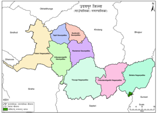
Belaka is a municipality located in Udayapur District of Province No. 1 of Nepal. It is one of four urban municipalities located in Udayapur District.
Sundar Haraicha is a municipality in Morang District of Province No. 1 in Nepal. It is centered around Biratchowk town which is the gateway to Biratnagar. It borders Itahari Sub- Metropolitan city to the West, Dharan Sub- Metropolitan city to the Northwest and Belbari municipality to the East and is connected by the Mahendra Highway. It is one of the fastest growing cities in the Eastern Nepal and the second largest city of Morang district after Biratnagar with 121,305 inhabitants living in 26,677 households. It consists the town centres of Biratchowk and Gothgaun which are parts of the Greater Birat Development Area which incorporates the cities of Biratnagar-Itahari-Gothgau-Biratchowk-Dharan primarily located on the Koshi Highway in Eastern Nepal, with an estimated total urban agglomerated population of 804,300 people living in 159,332 households.


