Pratt Regional Airport

Last updated
Pratt Regional Airport

former Pratt AAF
Pratt Regional Airport KS 2006 USGS.jpg
2008 USGS photo
Summary
Airport typePublic
OwnerPratt Airport Authority
Serves Pratt, Kansas
Elevation  AMSL 1,953 ft / 595 m
Coordinates 37°42′09″N098°44′49″W / 37.70250°N 98.74694°W / 37.70250; -98.74694
Website www.PrattAirportAuthority.com
Runways
Direction LengthSurface
ftm
17/355,5001,676Concrete
Statistics (2008)
Aircraft operations11,450
Based aircraft25

Pratt Regional Airport( IATA : PTT, ICAO : KPTT, FAA LID : PTT) is a public airport five miles north of Pratt, in Pratt County, Kansas. [1] Previously known as Pratt Industrial Airport, it is on the site of the former Pratt Army Airfield .

An IATA airport code, also known as an IATA location identifier, IATA station code or simply a location identifier, is a three-letter code designating many airports around the world, defined by the International Air Transport Association (IATA). The characters prominently displayed on baggage tags attached at airport check-in desks are an example of a way these codes are used.

ICAO airport code four-letter code designating many airports around the world

The ICAOairport code or location indicator is a four-letter code designating aerodromes around the world. These codes, as defined by the International Civil Aviation Organization and published in ICAO Document 7910: Location Indicators, are used by air traffic control and airline operations such as flight planning.

Federal Aviation Administration United States Government agency dedicated to civil aviation matters

The Federal Aviation Administration (FAA) is a governmental body of the United States with powers to regulate all aspects of civil aviation in that nation as well as over its surrounding international waters. Its powers include the construction and operation of airports, air traffic management, the certification of personnel and aircraft, and the protection of U.S. assets during the launch or re-entry of commercial space vehicles. Powers over neighboring international waters were delegated to the FAA by authority of the International Civil Aviation Organization.

Contents

Facilities

Pratt Regional Airport covers 2,569 acre s (1,040  ha ) at an elevation of 1,953 feet (595 m). Its one runway, 17/35, is 5,500 by 100 feet (1,676 x 30 m). [1] The facility had three 8,000 feet (2,400 m) runways: 13/31 (now closed), 04/22 (also closed), and runway 17/35 that has since been shortened by 2500 feet.

Acre unit of area

The acre is a unit of land area used in the imperial and US customary systems. It is traditionally defined as the area of one chain by one furlong, which is exactly equal to 10 square chains, ​1640 of a square mile, or 43,560 square feet, and approximately 4,047 m2, or about 40% of a hectare. Based upon the International yard and pound agreement of 1959, an acre may be declared as exactly 4,046.8564224 square metres. The acre is a statute measure in the United States and was formerly one in the United Kingdom and almost all countries of the former British Empire, although informal use continues.

Hectare metric unit of area

The hectare is an SI accepted metric system unit of area equal to a square with 100-metre sides, or 10,000 m2, and is primarily used in the measurement of land. There are 100 hectares in one square kilometre. An acre is about 0.405 hectare and one hectare contains about 2.47 acres.

In the year ending August 13, 2008 the airport had 11,450 aircraft operations, average 31 per day: 96% general aviation, 3% air taxi, and 1% military. 25 aircraft were then based at this airport: 68% single-engine and 32% multi-engine. [1]

General aviation civil use of aircraft excluding commercial transportation

General Aviation (GA) represents the 'private transport' and recreational flying component of aviation.

Air taxi on-demand commercial air transportation, particularly of smaller quantities of passenger or cargo by aeroplane or helicopter

An air taxi is a small commercial aircraft which makes short flights on demand.

Related Research Articles

Portland–Troutdale Airport airport in Oregon, United States of America

Portland–Troutdale Airport is a public use airport located 10 nautical miles east of the central business district of Portland, in Multnomah County, Oregon, United States. Also known as Troutdale Airport, it is located in Troutdale. It is one of four airports in the Portland metropolitan area owned and operated by the Port of Portland. It is included in the Federal Aviation Administration (FAA) National Plan of Integrated Airport Systems for 2017–2021, in which it is categorized as a regional general aviation facility.

Liberal Mid-America Regional Airport airport in Kansas, United States of America

Liberal Mid-America Regional Airport is two miles west of Liberal, in Seward County, Kansas. It is used for general aviation and was at one point subsidized by the Essential Air Service program. Formerly Liberal Municipal Airport, it hosts the Mid-America Air Museum.

Wichita Falls Municipal Airport airport in Texas, United States of America

Wichita Falls Regional Airport is a public and military use airport six miles north of Wichita Falls in Wichita County, Texas. Its runways and taxiways are shared with Sheppard Air Force Base; most operations are military, but American Eagle flies to Dallas-Fort Worth International Airport.

Lima Allen County Airport airport in Ohio, United States of America

Lima Allen County Airport is a public use airport located five nautical miles (9 km) southeast of the central business district of Lima, a city in Allen County, Ohio, United States. It is owned by the Allen County Regional Airport Authority.

Fulton County Airport (Indiana) airport in Indiana, United States of America

Fulton County Airport is two miles east of Rochester, in Fulton County, Indiana. It is owned by the Fulton County Airport Authority.

Lawrence Municipal Airport is three miles north of Lawrence, in Douglas County, Kansas.

Cessna Aircraft Field is a public use airport located four nautical miles southeast of the central business district of Wichita, in Sedgwick County, Kansas, United States. It is privately owned by the Cessna Aircraft Company.

Elkhart–Morton County Airport is a county-owned public-use airport located one nautical mile (1.85 km) east of the central business district of Elkhart, a city in Morton County, Kansas, United States.

Emporia Municipal Airport is a city-owned public-use airport, located five miles south of Emporia, in Lyon County, Kansas.

Hill City Municipal Airport is a mile northeast of Hill City, in Graham County, Kansas.

Hutchinson Municipal Airport (Kansas) airport in Kansas, United States of America

Hutchinson Municipal Airport is a city-owned public airport three miles east of Hutchinson, in Reno County, Kansas.

Porter County Regional Airport airport in Indiana, United States of America

Porter County Regional Airport is a public use airport one nautical mile (1.8 km) southeast of the central business district of Valparaiso, a city in Porter County, Indiana, United States. The Porter County Municipal Airport Authority owns the airport.

Michigan City Municipal Airport airport in Indiana, United States of America

Michigan City Municipal Airport is a public use airport located three nautical miles east of the central business district of Michigan City, in LaPorte County, Indiana, United States. The airport is publicly owned by the Michigan City Board of Aviation Commissioners.

Newton City/County Airport airport in Kansas, United States of America

Newton City-County Airport is three miles east of Newton, in Harvey County, Kansas. It is owned by the City of Newton and Harvey County.

Baker City Municipal Airport airport in Oregon, United States of America

Baker City Municipal Airport is three miles north of Baker City, in Baker County, Oregon. The National Plan of Integrated Airport Systems for 2011–2015 categorized it as a general aviation facility.

Strother Field airport in Kansas, United States of America

Strother Field is a public airport located in Cowley County, Kansas, United States. It is located five nautical miles southwest of the central business district of Winfield and north of Arkansas City. The airport is jointly owned by both cities. This airport is included in the National Plan of Integrated Airport Systems for 2011–2015, which categorized it as a general aviation facility.

Independence Municipal Airport (Kansas) airport in Kansas, United States of America

Independence Municipal Airport is six miles southwest of Independence, in Montgomery County, Kansas. The National Plan of Integrated Airport Systems for 2011–2015 categorized it a general aviation facility.

Ankeny Regional Airport IATA code IKV

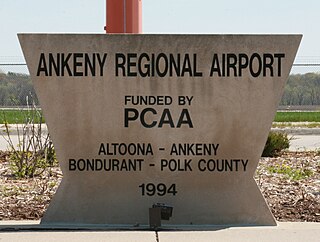
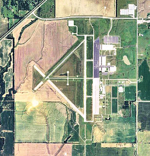
Ankeny Regional Airport is a public airport located one mile (2 km) southeast of the central business district of Ankeny, a city in Polk County, Iowa, United States. It is owned by the Polk County Aviation Authority.

Danville Regional Airport airport in Virginia, United States of America

Danville Regional Airport is three miles east of Danville, in southern Virginia. The Federal Aviation Administration (FAA) National Plan of Integrated Airport Systems for 2017–2021 categorized it as a regional general aviation facility.

Alva Regional Airport airport in Oklahoma, United States of America

Alva Regional Airport is a city-owned, public-use airport located two nautical miles (4 km) south of the central business district of Alva, a city in Woods County, Oklahoma, United States. It is included in the National Plan of Integrated Airport Systems for 2011–2015, which categorized it as a general aviation facility.

References

  1. 1 2 3 4 FAA Airport Master Record for PTT ( Form 5010 PDF ). Federal Aviation Administration. Effective 30 June 2011.
The National Map

The National Map is a collaborative effort of the United States Geological Survey (USGS) and other federal, state, and local agencies to improve and deliver topographic information for the United States. The purpose of the effort is to provide "...a seamless, continuously maintained set of public domain geographic base information that will serve as a foundation for integrating, sharing, and using other data easily and consistently".