Prebends Bridge

Last updated

Prebends Bridge
Prebends Bridge, Durham in Winter, December 2012.jpg
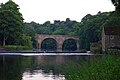
Prebends Bridge from upstream
Coordinates 54°46′15″N1°34′46″W / 54.7709°N 1.5794°W / 54.7709; -1.5794
OS grid reference NZ271418
CarriesPedestrians
Crosses River Wear
Locale County Durham
Owner Durham Cathedral
Heritage status Grade I listed
Preceded by Kingsgate Bridge
Followed by Framwellgate Bridge
Characteristics
DesignSemi-circular arch bridge
MaterialStone
No. of spans3
History
DesignerGeorge Nicholson
Construction start1772
Construction end1778
Location
Prebends Bridge

Prebends Bridge, along with Framwellgate and Elvet bridges, is one of three stone-arch bridges in the centre of Durham, England, that cross the River Wear.

Contents

History

Prebends Bridge was designed by George Nicholson [1] and built from 1772 to 1778. The bridge was built on the instructions of the Dean of Durham and served as a private road for the Dean and Chapter of Durham, giving access from the south through the Watergate. [2]

It replaced a temporary bridge built after the footbridge, built in 1574, was swept away during a flood in 1771. [3] The current bridge affords an excellent view of the cathedral and was built specifically with aesthetic considerations in mind - it was built slightly north of the prior bridge, at a wider part of the river, to improve the views available. [4] Trees were planted along the riverbank to complete the Romantic picture. [2]

Forming part of the estate of Durham Cathedral, the bridge is a Grade I listed building and is situated below the Watergate at the end of South Bailey (with which it is in concurrence), just after St Cuthbert's Society. Although the bridge is wide enough for vehicles, it is mainly used as a footbridge as it only leads to the Riverside paths and up to a closed road barrier to South Bailey. The bridge was restored from 1955 to 1956.

In autumn 2010 the bridge was temporarily reopened to road traffic under 3 tonnes while Saddler Street was closed because of extensive repaving works as part of the Heart of the City project, sponsored by Durham City Vision. [5]

Plaque

Prebends Bridge has a plaque to display Sir Walter Scott's words about Durham: [6]

Grey towers of Durham
Yet well I love thy mixed and massive piles
Half church of God, half castle ‘gainst the Scot
And long to roam these venerable aisles
With records stored of deeds long since forgot

Next bridge upstream River Wear Next bridge downstream
Kingsgate Bridge Prebends Bridge
Grid reference NZ2714541856
Framwellgate Bridge

Related Research Articles

<span class="mw-page-title-main">Suspension bridge</span> Type of bridge

A suspension bridge is a type of bridge in which the deck is hung below suspension cables on vertical suspenders. The first modern examples of this type of bridge were built in the early 1800s. Simple suspension bridges, which lack vertical suspenders, have a long history in many mountainous parts of the world.

<span class="mw-page-title-main">Durham, England</span> City in County Durham, England

Durham is a cathedral city and civil parish in the county of Durham, England. It is the county town and contains the headquarters of Durham County Council, the unitary authority which governs the district of County Durham. The built-up area had a population of 50,510 at the 2021 Census.

<span class="mw-page-title-main">Chichester Cathedral</span> Cathedral in West Sussex, England

Chichester Cathedral, formally known as the Cathedral Church of the Holy Trinity, is the seat of the Anglican Bishop of Chichester. It is located in Chichester, in West Sussex, England. It was founded as a cathedral in 1075, when the seat of the bishop was moved from Selsey.

<span class="mw-page-title-main">Durham Cathedral</span> Church in Durham, County Durham, England

Durham Cathedral, formally the Cathedral Church of Christ, Blessed Mary the Virgin and St Cuthbert of Durham, is a Church of England cathedral in the city of Durham, England. The cathedral is the seat of the bishop of Durham and is the mother church of the diocese of Durham. It also contains the shrines of the Anglo-Saxon saints Cuthbert and Bede. There are daily Church of England services at the cathedral, and it received 727,367 visitors in 2019. It is a grade I listed building and forms part of the Durham Castle and Cathedral World Heritage Site.

<span class="mw-page-title-main">Pontoon bridge</span> Type of bridge

A pontoon bridge, also known as a floating bridge, uses floats or shallow-draft boats to support a continuous deck for pedestrian and vehicle travel. The buoyancy of the supports limits the maximum load that they can carry.

<span class="mw-page-title-main">Sunderland Bridge, County Durham</span> Bridge in Sunderland Bridge

Sunderland Bridge is a bridge just outside the village also called Sunderland Bridge in County Durham, England. It lies close to the confluence of the River Wear and River Browney.

<span class="mw-page-title-main">Footbridge</span> Bridge designed solely for pedestrians

A footbridge is a bridge designed solely for pedestrians. While the primary meaning for a bridge is a structure which links "two points at a height above the ground", a footbridge can also be a lower structure, such as a boardwalk, that enables pedestrians to cross wet, fragile, or marshy land. Bridges range from stepping stones–possibly the earliest man-made structure to "bridge" water–to elaborate steel structures. Another early bridge would have been simply a fallen tree. In some cases a footbridge can be both functional and artistic.

<span class="mw-page-title-main">The Bailey</span> Street in Durham, County Durham, England

The Bailey is a historic area in the centre of the city of Durham, County Durham, England. It consists of two streets, North Bailey and South Bailey. It is on a peninsula within a sharp meander along the River Wear, formed by an isostatic adjustment of the land. The name "The Bailey" derives from the outer bailey of the Norman motte and bailey-style Durham Castle. Vehicular access to the area is restricted by the Durham City congestion charge, which started in 2002 and is the UK's oldest such scheme.

<span class="mw-page-title-main">History of Newcastle upon Tyne</span> Development of a city in North East England

The history of Newcastle upon Tyne dates back almost 2,000 years, during which it has been controlled by the Romans, the Angles and the Norsemen amongst others. Newcastle upon Tyne was originally known by its Roman name Pons Aelius. The name "Newcastle" has been used since the Norman Conquest of England. Due to its prime location on the River Tyne, the town developed greatly during the Middle Ages and it was to play a major role in the Industrial Revolution, being granted city status in 1882. Today, the city is a major retail, commercial and cultural centre.

<span class="mw-page-title-main">Barnes Railway Bridge</span> Bridge in London, England

Barnes Railway Bridge is a Grade II listed railway bridge in the London Borough of Richmond upon Thames and the London Borough of Hounslow. It crosses the River Thames in London in a northwest to southeast direction at Barnes. It carries the South Western Railway's Hounslow Loop Line, and lies between Barnes Bridge and Chiswick stations. It can also be crossed on foot, and is one of only three bridges in London to combine pedestrian and rail use; the others being Hungerford Bridge and Golden Jubilee Bridges and Fulham Railway Bridge.

<span class="mw-page-title-main">Durham Regatta</span> Rowing event

Durham Regatta is a rowing regatta held annually on the second weekend in June on the River Wear in Durham, North East of England; It is known as the Henley of the North, but began several years before the more prestigious Henley Royal Regatta. Durham Regatta is the second-oldest rowing regatta in England, preceded only by Chester Regatta. The first regatta was held over 17–19 June 1834, opening with a six-oared race in 1834 won by Velocity, owned by W. L. Wharton, High Sheriff of Durham, against the Durham University Original Club in Sylph.

<span class="mw-page-title-main">Framwellgate Bridge</span> Grade I listed bridge in County Durham, United Kingdom

Framwellgate Bridge is a medieval masonry arch bridge across the River Wear, in Durham, England. It is a Grade I listed building.

<span class="mw-page-title-main">Chester city walls</span> Fortification in Chester, England

Chester city walls consist of a defensive structure built to protect the city of Chester in Cheshire, England. Their construction was started by the Romans when they established the fortress of Deva Victrix between 70 and 80 [CE]. It originated with a rampart of earth and turf surmounted by a wooden palisade. From about 100 CE they were reconstructed using sandstone, but were not completed until over 100 years later. Following the Roman occupation nothing is known about the condition of the walls until Æthelflæd refounded Chester as a burgh in 907. The defences were improved, although the precise nature of the improvement is not known. After the Norman conquest, the walls were extended to the west and the south to form a complete circuit of the medieval city. The circuit was probably complete by the middle of the 12th century.

David Rowell & Co. was a company based in Westminster, London that fabricated wrought iron and wire rope, built suspension footbridges, and structural steel frame buildings. They were established in 1855 and closed in 1970.

<span class="mw-page-title-main">River Wear</span> River in northeast England

The River Wear in Northern England rises in the Pennines and flows eastwards, mostly through County Durham, to the North Sea in the City of Sunderland. At 60 mi (97 km) long, it is one of the region's longest rivers. The Wear wends in a steep valley through the cathedral city of Durham and gives its name to Weardale in its upper reach and Wearside by its mouth.

<span class="mw-page-title-main">Barton Road Swing Bridge</span> Bridge in Greater Manchester, England

Barton Road Swing Bridge is a swing bridge for road traffic in Greater Manchester that crosses the Manchester Ship Canal between Trafford Park in the Metropolitan Borough of Trafford to Barton-upon-Irwell in the City of Salford. The bridge is a Grade II* listed building, and is part of a surrounding conservation area. It runs parallel to the Barton Swing Aqueduct which carries the Bridgewater Canal. The bridge opens regularly for traffic along the Manchester Ship Canal, which can cause delays for road traffic.

<span class="mw-page-title-main">Albert Bridge, Manchester</span> Bridge in Manchester, England

Albert Bridge is a Grade II listed skew arch bridge in Greater Manchester, England. A replacement for an earlier structure, New Bailey Bridge, it was completed in 1844. It crosses the River Irwell, connecting Salford to Manchester.

South Street is an affluent residential street in Durham, England, on the banks of the River Wear. It overlooks the Durham Cathedral, a UNESCO World Heritage Site, and Durham Castle. It is best known for its terraced houses, many of which are Grade II listed buildings built in the Tudor Revival architecture and architecture of the modern era.

<span class="mw-page-title-main">Great Flood of 1771</span> Severe flooding of many rivers in northern England in 1771

The Great Flood of 1771 affected several rivers, including the Tyne, Tees, Wear and Eden and settlements across Northern England from 16 and 17 November 1771. Its cause was a sudden thaw of the ice in upper Teesdale, a cloud burst over the Pennines and a continuous period of rain.

References

  1. Prebends Bridge at Structurae
  2. 1 2 Wright, Colin. "Durham, Prebends Bridge". www.bl.uk. Retrieved 25 December 2017.
  3. "The city of Durham - Rivers, bridges and mills | A History of the County of Durham: Volume 3 (pp. 62-64)". British-history.ac.uk. 22 June 2003. Retrieved 26 February 2013.
  4. "Historic Bridges - Durham World Heritage Site". www.durhamworldheritagesite.com. Retrieved 25 December 2017.
  5. "Durhamcityvision.com". Durhamcityvision.com. Retrieved 26 February 2013.
  6. "Three Rivers Cycleway - Bridges - River Wear". Cycle-routes.org. Retrieved 26 February 2013.

54.771, -1.5793