Prees Branch Canal Nature Reserve

Last updated

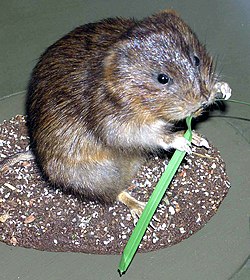
Prees Branch Canal Nature Reserve is a Shropshire Wildlife Trust nature reserve in the civil parish of Whixall, Shropshire, England. It is a Site of Special Scientific Interest due to the presence of rare pondweeds (Potamogeton), and also is the home of watervoles. Dragonflies and other invertebrates occur in the water, on the banks and in the air above. The reserve contains a number of uncommon plants and is visited by birds such as the kingfisher and waterfowl. Otters sometimes occur.

Shropshire Wildlife Trust organization

The Shropshire Wildlife Trust is a wildlife trust covering the geographic county of Shropshire, England.

Nature reserve protected area for flora, fauna or features of geological interest

A nature reserve is a protected area of importance for flora, fauna or features of geological or other special interest, which is reserved and managed for conservation and to provide special opportunities for study or research. Nature reserves may be designated by government institutions in some countries, or by private landowners, such as charities and research institutions, regardless of nationality. Nature reserves fall into different IUCN categories depending on the level of protection afforded by local laws. Normally it is more strictly protected than a nature park.

Civil parish territorial designation and lowest tier of local government in England, UK

In England, a civil parish is a type of administrative parish used for local government, they are a territorial designation which is the lowest tier of local government below districts and counties, or their combined form, the unitary authority. Civil parishes can trace their origin to the ancient system of ecclesiastical parishes which historically played a role in both civil and ecclesiastical administration; civil and religious parishes were formally split into two types in the 19th century and are now entirely separate. The unit was devised and rolled out across England in the 1860s.

A narrowboat enters the Prees Branch from the Llangollen Canal. Junction with the Prees Branch, Llangollen Canal - geograph.org.uk - 520143.jpg
A narrowboat enters the Prees Branch from the Llangollen Canal.
The canal at the reserve is no longer navigable. Prees Branch linear nature reserve - geograph.org.uk - 601650.jpg
The canal at the reserve is no longer navigable.
Broad-leaved pondweed (Potamogeton natans) PotamogetonNatans.jpg
Broad-leaved pondweed (Potamogeton natans)
European otter Otter in Southwold.jpg
European otter
Mallard duck Stockente male.jpg
Mallard duck
Eurasian kingfisher Common Kingfisher Alcedo atthis.jpg
Eurasian kingfisher
European watervole Water.vole.arp.jpg
European watervole
Brown hawker dragonfly Braune Mosaikjungfer (Aeshna grandis).jpg
Brown hawker dragonfly

The Prees Branch canal was originally meant to be an extension of the Ellesmere Canal (now the Llangollen Canal) to Prees, but was only constructed as far as Quina Brook. It is only navigable as far as a marina, beyond which the reserve is effectively a long pond and its banks. [1]

Ellesmere Canal

The Ellesmere Canal was a waterway in England and Wales that was planned to carry boat traffic between the rivers Mersey and Severn. The proposal would create a link between the Port of Liverpool and the mineral industries in north east Wales and the manufacturing centres in the West Midlands. However, the canal was never completed as intended because of its rising costs and failure to generate the expected commercial traffic.

Llangollen Canal canal in Wales and Shopshire, United Kingdom

The Llangollen Canal is a navigable canal crossing the border between England and Wales. The waterway links Llangollen in Denbighshire, north Wales, with Hurleston in south Cheshire, via the town of Ellesmere, Shropshire. The name, which was coined in the 1980s, is a modern designation for parts of the historic Ellesmere Canal and the Llangollen navigable feeder, both of which became part of the Shropshire Union Canals in 1846.

Quina Brook village in United Kingdom

Quina Brook is a hamlet in north Shropshire, near the border between England and Wales. Population details for the 2011 census are found under Wem Rural.

Related Research Articles

North Shropshire

North Shropshire was a local government district in Shropshire, England. The district council was based at Edinburgh House, in Wem. Other settlements included the towns of Ellesmere, Market Drayton, Wem and Whitchurch, as well as the large villages of Shawbury and Baschurch. The district bordered onto Wales, Cheshire and Staffordshire as well as the Shropshire districts of Oswestry, Shrewsbury and Atcham and the unitary Telford and Wrekin.

Wyre Forest

Wyre Forest is a large, semi-natural woodland and forest measuring 26.34 square kilometres (10.17 sq mi) which straddles the borders of Worcestershire and Shropshire, England.

This large hill in the centre of Oswestry is a 3 hectare area consisting of acid grassland and naturally regenerated areas of woodland and scrub.

Montgomery Canal canal in Shropshire and Wales, United Kingdom

The Montgomery Canal, known colloquially as "The Monty", is a partially restored canal in Powys, in eastern Wales, and in northwest Shropshire, in western England. The canal runs 33 miles (53 km) from the Llangollen Canal to Newtown, via Llanymynech and Welshpool.

Prees a village located in Shropshire, United Kingdom

Prees is a village and civil parish in north Shropshire, near the border between England and Wales. Its name is Celtic and means "brushwood".

Telford Town Park

Telford Town Park is a park and Local Nature Reserve in Telford in Shropshire. In 2015, it was voted "UK's Best Park" in the inaugural public competition organised by Fields in Trust

Whixall village in the United Kingdom

Whixall is, by land area, the third largest inland village in England and a civil parish in Shropshire, England. It is documented in the Domesday Book as having been in existence in 1086.

Frankton Junction

Frankton Junction is the name of the canal junction where the Montgomery Canal terminates and meets the Llangollen Canal at Lower Frankton, Shropshire, England.

Fens Pools

Fens Pools is a 37.6 hectare biological site of Special Scientific Interest in the West Midlands. The site was notified in 1989 under the Wildlife and Countryside Act 1981 and is currently managed by the Country Trust.

Dimminsdale

Dimminsdale is a 37 hectare geological biological and Site of Special Scientific Interest partly in Derbyshire and partly in Leicestershire. It is located east of Calke in Derbyshire. It is a Geological Conservation Review site, and a area of 23.5 hectares is owned by Severn Trent Water and managed by the Leicestershire and Rutland Wildlife Trust.

Frays Farm Meadows

Frays Farm Meadows is a 28.2-hectare (70-acre) biological Site of Special Scientific Interest near Denham in the London Borough of Hillingdon. It was notified as an SSSI in 1981, and has been managed by the London Wildlife Trust on behalf of Hillingdon Council since 1999. It is part of the Colne Valley Regional Park.

Prees Heath Common is a nature reserve near Whitchurch in the county of Shropshire, England. Butterfly Conservation owns and manages this reserve. It comprises 145 acres (59 ha).

Whitchurch Waterways Country Park

Whitchurch Waterways Country park is an open space to the west of the Shropshire town of Whitchurch. Opened in its current form in 2002, it is a recreation area and Green corridor that takes in a town park, Greenfields Nature Reserve, Staggs Brook and the Whitchurch Arm of the Llangollen Canal. The area is maintained by Whitchurch Town Council and owned by Whitchurch Waterway Trust. There are plans to extend the canal within the country park and create a basin for Narrowboat moorings.

Titchmarsh Nature Reserve nature reserve in the United Kingdom

Titchmarsh Nature Reserve is a 72.7 hectare Local Nature Reserve north of Thrapston in East Northamptonshire. It is owned and managed by the Wildlife Trust for Bedfordshire, Cambridgeshire and Northamptonshire. It is part of the Upper Nene Valley Gravel Pits Site of Special Scientific Interest.

Duston Mill Meadow nature reserve in the United Kingdom

Duston Mill Meadow is a one hectare nature reserve in Northampton. It is managed by the Wildlife Trust for Bedfordshire, Cambridgeshire and Northamptonshire (WTBCN).

Stoke Bruerne Brick Pits nature reserve in the United Kingdom

Stoke Bruerne Brick Pits is a six hectare nature reserve in Stoke Bruerne in Northamptonshire. It is managed by the Wildlife Trust for Bedfordshire, Cambridgeshire and Northamptonshire.

Grafton Regis Meadow nature reserve in the United Kingdom

Grafton Regis Meadow is a 2 hectare nature reserve east of Grafton Regis in Northamptonshire. It is managed by the Wildlife Trust for Bedfordshire, Cambridgeshire and Northamptonshire.

Finedon Cally Banks nature reserve in the United Kingdom

Finedon Cally Banks is a 2.5 hectare nature reserve north-east of Wellingborough in Northamptonshire. It is managed by the Wildlife Trust for Bedfordshire, Cambridgeshire and Northamptonshire.

References

  1. Prees Branch Canal Shropshire Wildlife Trust website

Coordinates: 52°53′49″N2°44′56″W / 52.89692°N 2.74882°W / 52.89692; -2.74882

Geographic coordinate system Coordinate system

A geographic coordinate system is a coordinate system that enables every location on Earth to be specified by a set of numbers, letters or symbols. The coordinates are often chosen such that one of the numbers represents a vertical position and two or three of the numbers represent a horizontal position; alternatively, a geographic position may be expressed in a combined three-dimensional Cartesian vector. A common choice of coordinates is latitude, longitude and elevation. To specify a location on a plane requires a map projection.