
Seismology is the scientific study of earthquakes and the generation and propagation of elastic waves through the Earth or other planetary bodies. It also includes studies of earthquake environmental effects such as tsunamis as well as diverse seismic sources such as volcanic, tectonic, glacial, fluvial, oceanic microseism, atmospheric, and artificial processes such as explosions and human activities. A related field that uses geology to infer information regarding past earthquakes is paleoseismology. A recording of Earth motion as a function of time, created by a seismograph is called a seismogram. A seismologist is a scientist works in basic or applied seismology.
The moment magnitude scale is a measure of an earthquake's magnitude based on its seismic moment. Mw was defined in a 1979 paper by Thomas C. Hanks and Hiroo Kanamori. Similar to the local magnitude/Richter scale (ML ) defined by Charles Francis Richter in 1935, it uses a logarithmic scale; small earthquakes have approximately the same magnitudes on both scales. Despite the difference, news media often use the term "Richter scale" when referring to the moment magnitude scale.

The core–mantle boundary (CMB) of Earth lies between the planet's silicate mantle and its liquid iron–nickel outer core, at a depth of 2,891 km (1,796 mi) below Earth's surface. The boundary is observed via the discontinuity in seismic wave velocities at that depth due to the differences between the acoustic impedances of the solid mantle and the molten outer core. P-wave velocities are much slower in the outer core than in the deep mantle while S-waves do not exist at all in the liquid portion of the core. Recent evidence suggests a distinct boundary layer directly above the CMB possibly made of a novel phase of the basic perovskite mineralogy of the deep mantle named post-perovskite. Seismic tomography studies have shown significant irregularities within the boundary zone and appear to be dominated by the African and Pacific Large low-shear-velocity provinces (LLSVP).
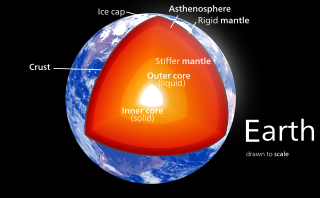
Earth's inner core is the innermost geologic layer of the planet Earth. It is primarily a solid ball with a radius of about 1,220 km (760 mi), which is about 20% of Earth’s radius or 70% of the Moon's radius.

Don Lynn Anderson was an American geophysicist who made significant contributions to the understanding of the origin, evolution, structure, and composition of Earth and other planets. An expert in numerous scientific disciplines, Anderson's work combined seismology, solid state physics, geochemistry and petrology to explain how the Earth works. Anderson was best known for his contributions to the understanding of the Earth's deep interior, and more recently, for the plate theory hypothesis that hotspots are the product of plate tectonics rather than narrow plumes emanating from the deep Earth. Anderson was Professor (Emeritus) of Geophysics in the Division of Geological and Planetary Sciences at the California Institute of Technology (Caltech). He received numerous awards from geophysical, geological and astronomical societies. In 1998 he was awarded the Crafoord Prize by the Royal Swedish Academy of Sciences along with Adam Dziewonski. Later that year, Anderson received the National Medal of Science. He held honorary doctorates from Rensselaer Polytechnic Institute and the University of Paris (Sorbonne), and served on numerous university advisory committees, including those at Harvard, Princeton, Yale, University of Chicago, Stanford, University of Paris, Purdue University, and Rice University. Anderson's wide-ranging research resulted in hundreds of published papers in the fields of planetary science, seismology, mineral physics, petrology, geochemistry, tectonics and the philosophy of science.
Density gradient is a spatial variation in density over an area. The term is used in the natural sciences to describe varying density of matter, but can apply to any quantity whose density can be measured.
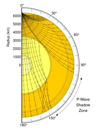
A seismic shadow zone is an area of the Earth's surface where seismographs cannot detect direct P waves and/or S waves from an earthquake. This is due to liquid layers or structures within the Earth's surface. The most recognized shadow zone is due to the core-mantle boundary where P waves are refracted and S waves are stopped at the liquid outer core; however, any liquid boundary or body can create a shadow zone. For example, magma reservoirs with a high enough percent melt can create seismic shadow zones.
Seismic magnitude scales are used to describe the overall strength or "size" of an earthquake. These are distinguished from seismic intensity scales that categorize the intensity or severity of ground shaking (quaking) caused by an earthquake at a given location. Magnitudes are usually determined from measurements of an earthquake's seismic waves as recorded on a seismogram. Magnitude scales vary based on what aspect of the seismic waves are measured and how they are measured. Different magnitude scales are necessary because of differences in earthquakes, the information available, and the purposes for which the magnitudes are used.

Adam Marian Dziewoński was a Polish-American geophysicist who made seminal contributions to the determination of the large-scale structure of the Earth's interior and the nature of earthquakes using seismological methods. He spent most of his career at Harvard University, where he was the Frank B. Baird, Jr. Professor of Science.
Body-waves consist of P-waves that are the first to arrive, or S-waves, or reflections of either. Body-waves travel through rock directly.
Lunar seismology is the study of ground motions of the Moon and the events, typically impacts or moonquakes, that excite them.
The Adams–Williamson equation, named after Leason H. Adams and E. D. Williamson, is an equation used to determine density as a function of radius, more commonly used to determine the relation between the velocities of seismic waves and the density of the Earth's interior. Given the average density of rocks at the Earth's surface and profiles of the P-wave and S-wave speeds as function of depth, it can predict how density increases with depth. It assumes that the compression is adiabatic and that the Earth is spherically symmetric, homogeneous, and in hydrostatic equilibrium. It can also be applied to spherical shells with that property. It is an important part of models of the Earth's interior such as the Preliminary reference Earth model (PREM).
An SKS wave is a type of seismic wave, with the three letters denoting the type of wave-motion through the mantle and outer core. The first S indicates that the wave travels as a shear or s-wave through the mantle, the K shows that the wave travels as a compressional or p-wave through the outer core, and the final S indicates an s-wave, returning through the mantle. As shear waves cannot be transmitted through the liquid Outer core, some of the s-wave energy is converted to p-wave energy as the wave hits the Core–mantle boundary. When the wave hits the core-mantle boundary as it leaves the core, some energy is converted back to shear energy before the wave travels through the mantle. SKS waves can be observed by seismometers roughly 60-141° from an earthquake according to the Preliminary reference Earth model.

In seismology, a tsunami earthquake is an earthquake which triggers a tsunami of significantly greater magnitude, as measured by shorter-period seismic waves. The term was introduced by Japanese seismologist Hiroo Kanamori in 1972. Such events are a result of relatively slow rupture velocities. They are particularly dangerous as a large tsunami may arrive at a coastline with little or no warning.
The 1970 Colombia earthquake occurred in Colombia on July 31.
Brian Leslie Norman Kennett is a mathematical physicist and seismologist. He is now a professor emeritus at the Australian National University.
The lower mantle, historically also known as the mesosphere, represents approximately 56% of Earth's total volume, and is the region from 660 to 2900 km below Earth's surface; between the transition zone and the outer core. The preliminary reference Earth model (PREM) separates the lower mantle into three sections, the uppermost (660–770 km), mid-lower mantle (770–2700 km), and the D layer (2700–2900 km). Pressure and temperature in the lower mantle range from 24–127 GPa and 1900–2600 K. It has been proposed that the composition of the lower mantle is pyrolitic, containing three major phases of bridgmanite, ferropericlase, and calcium-silicate perovskite. The high pressure in the lower mantle has been shown to induce a spin transition of iron-bearing bridgmanite and ferropericlase, which may affect both mantle plume dynamics and lower mantle chemistry.
Miaki Ishii is a seismologist and Professor of Earth and Planetary Sciences at Harvard University.

International Association of Seismology and Physics of the Earth's Interior (IASPEI) is an international organization promoting the study of earthquakes and other seismic sources, the propagation of seismic waves, and the internal structure, properties and processes of the Earth.

Seismic velocity structure is the distribution and variation of seismic wave speeds within Earth's and other planetary bodies' subsurface. It is reflective of subsurface properties such as material composition, density, porosity, and temperature. Geophysicists rely on the analysis and interpretation of the velocity structure to develop refined models of the subsurface geology, which are essential in resource exploration, earthquake seismology, and advancing our understanding of Earth's geological development.
