
Marlborough is a market town and civil parish in the English county of Wiltshire on the Old Bath Road, the old main road from London to Bath. It boasts the second widest high street in Britain, after Stockton-on-Tees. The town is on the River Kennet, 24 miles (39 km) north of Salisbury and 10 miles (16 km) south-southeast of Swindon.

Hungerford is a historic market town and civil parish in Berkshire, England, 8 miles (13 km) west of Newbury, 9 miles (14 km) east of Marlborough, 27 miles (43 km) northeast of Salisbury and 60 miles west of London. The Kennet and Avon Canal passes through the town from the west alongside the River Dun, a major tributary of the River Kennet. The confluence with the Kennet is to the north of the centre whence canal and river both continue east. Amenities include schools, shops, cafés, restaurants, and facilities for the main national sports. The railway station is a minor stop on the London to Exeter Line.

Berwick Bassett is a small village and civil parish in Wiltshire, England, about 6 miles (10 km) northwest of Marlborough and 8 miles (13 km) southwest of Swindon. The village is on the west bank of a headstream of the River Kennet and close to the A4361 road, formerly the A361, which links Devizes and Avebury with Wroughton and Swindon.

East Kennett is a small village and civil parish in Wiltshire, England, 5 miles (8.0 km) west of Marlborough. The United Kingdom Census 2011 recorded a parish population of 84.

Everleigh, pronounced and also sometimes spelt Everley, is a village and civil parish in east Wiltshire, England, about 4 1⁄2 miles (7 km) southeast of the town of Pewsey, towards the northeast of Salisbury Plain.

Grafton is a civil parish in Wiltshire, England, in the Vale of Pewsey about 7 miles (11 km) southeast of Marlborough. Its main settlement is the village of East Grafton, on the A338 Burbage - Hungerford road; the parish includes the village of Wilton and the hamlets of West Grafton, Marten and Wexcombe.

Fyfield is a village and civil parish in the English county of Wiltshire, in the Kennet Valley about 2.5 miles (4.0 km) west of Marlborough. The village is on the A4 road which was historically the main route from London to the west of England.
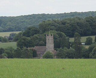
West Overton is a village and civil parish in the English county of Wiltshire, about 3.5 miles (5.6 km) west of Marlborough. The river Kennet runs immediately north of the village, separating it from the A4.
Lockeridge is a village in Wiltshire, England. It lies at the edge of the West Woods in the Kennet Valley, 2.9 miles (4.7 km) west of Marlborough, 3.1 miles (5.0 km) east of Avebury and 10.5 miles (16.9 km) south of Swindon. It is 0.6 miles (0.97 km) south of the A4 road which was historically the main route from London to the west of England.
Lyneham is a large village in north Wiltshire, England, within the civil parish of Lyneham and Bradenstoke, and situated 4 miles (6.4 km) southwest of Royal Wootton Bassett, 5.5 miles (8.9 km) north of Calne and 11 miles (18 km) southwest of Swindon. The village is on the A3102 road between Calne and Wootton Bassett.

Clatford is a small hamlet approximately 1 mile (1.6 km) west of the village of Manton and about 2 miles (3.2 km) west of Marlborough, which is the nearest town, in Wiltshire, England. It is just south of the River Kennet and the A4 primary route.

Manton is a small village in Wiltshire, England, on the western outskirts of Marlborough just off the A4 Bath Road.

Upper Clatford is a village and civil parish in Hampshire, England. The village is in the valley of the River Anton, 3.5 miles (5.6 km) upstream from the point where it joins the River Test at the south.
Semington is a village and civil parish in Wiltshire, England. The village is about 2 miles (3 km) south of Melksham and about 3 miles (5 km) northeast of Trowbridge. The parish includes the hamlets of Little Marsh and Littleton.

Milton Lilbourne is a village and civil parish in the county of Wiltshire, England, in the Vale of Pewsey between Pewsey and Burbage. It is largely a mixed residential area centred on the Manor. The nearest town is Marlborough, 5.5 miles (8.9 km) to the north.

Berryfield is a small village to the south of the town of Melksham, in Wiltshire, England. The village is separated from the southwestern outskirts of Melksham by the A350 road and about 500 metres of farmland; it falls within the civil parish of Melksham Without. The Bristol Avon is about 0.6 miles (1 km) west of the village. Although close to Melksham town, Berryfield remains a separate community.

Staverton is a village and civil parish in the west of the English county of Wiltshire, about 1.75 miles (2.82 km) north of the centre of Trowbridge and 3 miles (4.8 km) east of Bradford on Avon.

Manningford is a civil parish in Wiltshire, England. The parish includes the villages of Manningford Abbots, Manningford Bohune and Manningford Bruce, and the hamlet of Manningford Bohune Common, together known as the Manningfords.

Netherhampton is a village and civil parish in Wiltshire, England, immediately west of the city of Salisbury. The village is about 2 miles (3.2 km) from the city centre.

Savernake is a civil parish immediately south and southeast of Marlborough in Wiltshire, England. The settlements in the parish are the hamlets of Cadley and Clench Common. Savernake Forest covers the eastern half of the parish.
