
Crete is the largest and most populous of the Greek islands, the 88th largest island in the world and the fifth largest island in the Mediterranean Sea, after Sicily, Sardinia, Cyprus, and Corsica. Crete rests about 160 km (99 mi) south of the Greek mainland, and about 100 km (62 mi) southwest of Anatolia. Crete has an area of 8,450 km2 (3,260 sq mi) and a coastline of 1,046 km (650 mi). It bounds the southern border of the Aegean Sea, with the Sea of Crete to the north and the Libyan Sea to the south. Crete covers 260 km from west to east but is narrow from north to south, spanning three longitudes but only half a latitude.

Chania, also spelled Hania, is a city in Greece and the capital of the Chania regional unit. It lies along the north west coast of the island Crete, about 70 km (43 mi) west of Rethymno and 145 km (90 mi) west of Heraklion.

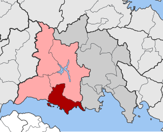
Voies is a former municipality in Laconia, Peloponnese, Greece. Since the 2011 local government reform it is part of the municipality Monemvasia, of which it is a municipal unit. The municipal unit has an area of 215.527 km2. It is on the southern tip of Cape Malea. It is a predominantly agricultural region with a few minor villages and one dominant town. Vatika is the common term for the area, but Voies is used in a more official context, particularly for postal situations. Voion, the genitive, is used for description: for example, to differentiate the village of Agios Nikolaos in Voies from other villages and towns of the same name, one would use Agios Nikolaos Voion. Neapoli is the administrative capital of the municipality, and is also the urban center to the numerous villages that surround the hinterland.

Monemvasia is a town and municipality in Laconia, Greece. The town is located in mainland Greece on a tied island off the east coast of the Peloponnese, surrounded by the Myrtoan Sea. Monemvasia is connected to the rest of the mainland by a tombolo 400 metres (1,300 ft) in length.

Troodos is the largest mountain range in Cyprus, located in roughly the center of the island. Its highest peak is Mount Olympus, also known as Chionistra, at 1,952 metres (6,404 ft), which hosts the Sun Valley and North Face ski areas with their five ski lifts.

Skopelos is a Greek island in the western Aegean Sea. Skopelos is one of several islands which comprise the Northern Sporades island group, which lies east of the Pelion peninsula on the mainland and north of the island of Euboea. It is part of the Thessaly region. Skopelos is also the name of the main port and the municipal center of the island. The other communities of the island are Glossa and Neo Klima (Elios). The geography of Skopelos includes two mountains over 500 m (1,640 ft); Delphi (681 m/2,234 ft) in the center of the island, and Palouki in the southeast. With an area of 96 km2 (37 sq mi) Skopelos is slightly larger than Mykonos (85 km2/33 sq mi) and Santorini (73 km2/28 sq mi). The nearest inhabited islands are Skiathos to the west and Alonnisos to the east.

Chania, also spelled Hania, is one of the four regional units of Crete; it covers the westernmost quarter of the island. Its capital is the city of Chania. Chania borders only one other regional unit: that of Rethymno to the east. The western part of Crete is bounded to the north by the Cretan Sea(part of the Aegean Sea) and to the west and south by the Mediterranean Sea and Libyan Sea. The regional unit also includes the southernmost island of Europe, Gavdos.
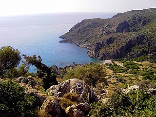
Lissus or Lissos was a town on the south coast of ancient Crete, which the anonymous Stadiasmus Maris Magni places between Syia and Calamyde. The Peutinger Table gives 16 M.P. as the distance between Cantanum and Lissus. It was one of the harbours of Elyrus. It was established in the Classical period and flourished until the Late Antiquity. Its name was made certain by inscriptions. The early history of the city is unknown. Based on inscriptions and coins of the 3rd century BCE, we know the city allied with King Magas of Cyrene, and joined the League of Oreians. The koinon of the Oreians consisted of the cities Lissus, Syia, Poikilassos, Tarrha, Yrtakina and Elyrus. Lissus had powerful trading and fishing fleets.

Agios Nikolaos is a village located 110 kilometers south-east of Thessaloniki on the Chalkidiki peninsula in Macedonia, Greece.

Stylos or Stilos is a village and part of the Apokoronas municipal unit in the Chania regional unit of the Greek island of Crete. The Greek etymology of the name of the village is 'column' or 'pillar'. No existing topographical or surviving architectural feature could account for this naming.
Tolofon is a village and a former municipality in Phocis, Greece. Since the 2011 local government reform it is part of the municipality Dorida, of which it is a municipal unit. The municipal unit has an area of 131.384 km2. The seat of the municipality was in Erateini. The ancient site of Tolophon is located in the northeastern part of the municipal unit. It is situated on the mountainous north coast of the Gulf of Corinth.
Maza is a small village in the municipality of Apokoronas of the Chania regional unit on the island of Crete, Greece. At the time of the 2011 census, it had 100 residents. The village is perched on a mountain slope some 150 m above the valley of the Boutakas (Μπούτακας) river, 1.7 km to the south of the Chania-Rethymno road.
Smari is a traditional small Cretan village, only 7 km (4 mi) away from the town of Kastelli and only 23 km (14 mi). away from Heraklion, which is the capital of the island of Crete. According to the 2021 census, it has 328 permanent inhabitants.

The Painted Churches in the Troödos Region is a UNESCO World Heritage Site in the Troödos Mountains of central Cyprus. The complex comprises ten Byzantine churches and monasteries richly decorated with Byzantine and post-Byzantine murals:
- Church of Agios Nikolaos tis Stegis in Kakopetria: An 11th-century monastery and the oldest surviving katholikon in Cyprus
- Agios Ioannis Lampadistis Monastery in Kalopanagiotis: A 13th-century monastery
- Church of Panagia Phorviotissa (Asinou) in Nikitari: A 12th-century church
- Church of Panagia tou Arakou in Lagoudhera: A 12th century church
- Church of Panagia in Moutoullas: A 13th-century chapel and the earliest example of steep-pitched wooden roofs
- Church of Archangelos Michael in Pedoulas: A late 15th-century church
- Church of Timios Stavros in Pelendri: A church containing unique 14th-century wall paintings
- Church of Panagia Podithou in Galata: An early-16th century church
- Church of Stavros Agiasmati in Platanistasa: A 14th-century church
- Church of Agia Sotira tou Soteros in Palaichori Oreinis: A 16th-century church.
Sirikari is a small mountain village located in western Crete, in the regional unit of Chania, Greece. It is part of the municipality of Kissamos. It is 55 km to the west from Chania and 17 km to the south from Kissamos. Sirikari differs from other typical Greek villages in that it comprises 12 scattered neighbourhoods. The ones that are not populated anymore are Micheliana and Marouliana or Felesiana). The name is suggested to derive from the Byzantine surname Sirikarios, which means the person who makes silk linen, generally the silk-worker.

Tirilye is a neighbourhood of the municipality and district of Mudanya, Bursa Province, Turkey. Its population is 1,409 (2022). With the 2013 Turkish local government reorganisation, its town (belde) status and its municipality (belediye) were abolished, and it was made a neighbourhood (mahalle). It is situated 12 km (7.46 mi) west of Mudanya along the Marmara seashore. The area, which was inhabited since the eighth century BC, was formerly known as Τρίγλεια, Trigleia or Βρύλλειον, Brylleion in Greek. The most important historical structure in Tirilye (Triglia) is that of the Byzantine Haghios Stefanos Church, known today as the Fatih Mosque. Mudanya, a residential and commercial development in this township is under state protection as a historical site.
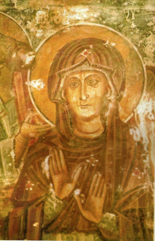
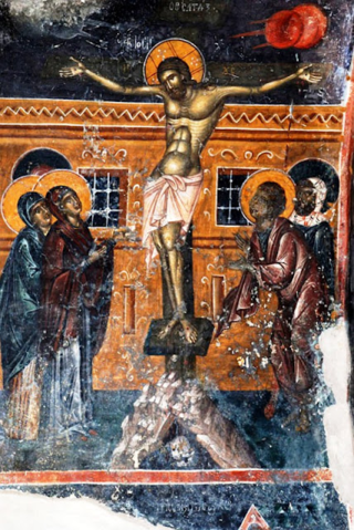
Ioannis Pagomenos was a Greek painter in the Byzantine style active in Venetian-ruled Crete. He created fresco cycles for rural Orthodox churches under commission from ordinary members of the local peasant communities, who acted as collective patrons. While he could be considered a forerunner to the Cretan School, which saw success in producing hybrid-style icons for an international clientele, his work was more traditional in character and only incorporated Western influences in secondary details, as it catered to regional tastes. His style nonetheless shows significant development over the years. His frescos survive in four districts of the Chania prefecture, with the majority in the mountainous province of Selino, which displays the highest density of church painting in Crete. His art influenced Andreas Pavias, Angelos Akotantos, Andreas Ritzos, and Nikolaos Tzafouris. By 1337/8 Pagomenos was working together with his son Nikolaos within the framework of a small family workshop of painters, other examples of which are known from contemporary Crete and the Aegean.
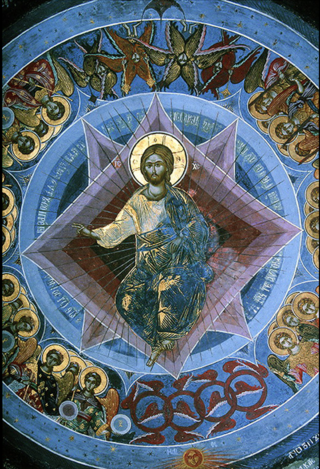
Fragkos Katelanos was a Greek painter. He specialized in icon and fresco-painting. His work resembles the Byzantine style of painting with attributes of the Cretan School. His work coincided with Theophanes the Cretan geographically and chronologically. His frescoes can be found in different parts of Greece. His signed work can be found at the Monastery of Great Lavra at Mount Athos. He is one of few Greek artists that were not associated with Venice or Crete. He mainly worked out of Ioannina. He was very popular during his time. Theophanes the Cretan was also associated with Mount Athos but he traveled back to Crete. He also spread the Cretan School to mainland Greece. Both Theophanes the Cretan, Katelanos influenced famous artist Dionysius of Fourna. Katelanos's frescos can be found all over Greece, including at Kozani, Ioannina, Kastoria and the Monastery of Varlaam in Meteora.
Manuel Fokas, also known as Manuele Fuca, was a Greek Byzantine painter. Most of his frescos have survived until today. Three churches in Crete containing Fokas's frescos are Saint George, Emparaso, Agios Konstantinos Avdou, and Saint George Apano Symi. Artists from Heraklion that his work influenced include: El Greco, Georgios Klontzas and Michael Damaskinos.

Aradaina is a village in Greece located in the Agios Ioannis Community of the Sfakia municipality in the Chania Regional Unit of Crete. According to the 2011 census it has 4 residents.
