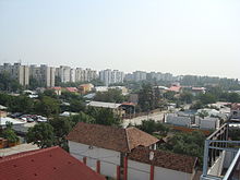
Progresul is a district in southern Bucharest's Sectorul 4, Romania.
Progresul is a district in southern Bucharest's Sectorul 4, Romania.

Riviera Beach is a census-designated place in Anne Arundel County, Maryland, United States. The population was 12,677 at the 2010 U.S. census.

Littleton Common is a census-designated place (CDP) in the town of Littleton in Middlesex County, Massachusetts, United States. The population was 2,789 at the 2010 census.

Rosenhayn is an unincorporated community and census-designated place (CDP) located within Deerfield Township, in Cumberland County, New Jersey, United States. It is part of the Vineland-Millville- Bridgeton Primary Metropolitan Statistical Area for statistical purposes. As of the 2010 United States Census, the CDP's population was 1,098.

Leith-Hatfield is a census-designated place (CDP) in Fayette County, Pennsylvania, United States. The population was 2,546 at the 2010 census, down from 2,820 at the 2000 census. The twin villages of Leith and Hatfield are located in South Union Township.

Rapid Valley is a census-designated place (CDP) and unincorporated community in Pennington County, South Dakota, United States, and a suburb of Rapid City. The population was 8,098 at the 2020 census. Rapid Valley has been a retreat for people living in Rapid City due to its low crime, cheap land, and views of the Black Hills. Rapid Valley is home to many industrial and financial businesses, and is the headquarters for many corporations specializing in transport and engineering.
Chanpatia is a city Nagar Panchayat situated on the bank of the Burhi Gandak River is the administrative headquarter of Chanpatia block in Paschim Champaran district near the Indo-Nepal border, 18 km from District headquarter Bettiah, 242 km north-west of capital city Patna in the state of Bihar, India. Chanpatia is famous for tasty Marcha Ka chura, Basmati rice and the famous Handi kabab.
Sojat Road is a census town in Sojat tehsil of Pali district in the Indian state of Rajasthan. Sojat Road train station is located on Ajmer-Marwar Junction route and the most convenient method of traveling is by train.
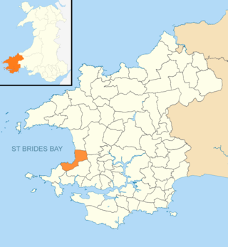
The Havens is the name of a community and an electoral ward in Pembrokeshire, West Wales.
KNFM, branded as "Lonestar 92.3", is a country music-formatted radio station that serves the Midland–Odessa metropolitan area of Texas, United States. The station is under ownership of Townsquare Media. Its studios are located on Highway 191 just west of Midland in rural Midland County.

The 321st Air Expeditionary Wing was a United States Air Force unit assigned United States Air Forces Central, the USAF component command of United States Central Command. The unit was reestablished on 1 November 2008 and was a nexus of all Coalition Air Force Training Teams and the Iraqi Air Force at COB Speicher. It was previously the 321st Bombardment Group (Medium), which flew B-25 Mitchells in combat with the Northwest African Strategic Air Force in 1943 and the Mediterranean Allied Tactical Air Force in 1944–45.
Ibrahimpatnam is a suburb of Hyderabad in Ranga Reddy district of the Indian state of Telangana. It is located in Ibrahimpatnam mandal of Ibrahimpatnam revenue division.
The Scoresby Hills, also called the Scoresby Mountains, are a mountain range on the east coast of Bathurst Island, Nunavut, Canada. It consists of low hills which in turn form part of the Arctic Cordillera mountain system.
Naval Auxiliary Landing Field Orange Grove or NALF Orange Grove is a military airport located southwest of Orange Grove, a city in Jim Wells County, Texas, United States. It was commissioned in 1951, and covers an area of 1,373 acres (5.56 km2). Owned by the United States Navy, it supports pilot training for NAS Kingsville. It has two runways, 1/19 and 13/31, each measuring 8,000 x 200 ft.

(+)-BW373U86 is an opioid analgesic drug used in scientific research.

Brasina is a village in Serbia. It is situated in the Mali Zvornik municipality, in the Mačva District of Central Serbia. The village has a Serb ethnic majority with a population of 1,663.

Tatari is a subdistrict in the district of Kesklinn (Midtown), Tallinn, the capital of Estonia. It has a population of 2,098.

Tometino Polje is a village in the municipality of Požega, western Serbia. According to the 2002 census, the village has a population of 373 people.

Rockport Air Force Station is a closed United States Air Force General Surveillance Radar station. It is located 4.1 miles (6.6 km) southwest of Lamar, Texas. It was closed in 1963.

Gwalior South Assembly constituency is one of the 230 Vidhan Sabha constituencies of Madhya Pradesh state in central India. This constituency came into existence in 2008, following the delimitation of the legislative assembly constituencies.
Jakhanian is a constituency of the Uttar Pradesh Legislative Assembly covering the city of Jakhanian in the Ghazipur district of Uttar Pradesh, India.
| Sectors of Bucharest |  | |
|---|---|---|
| Districts (quarters) |
| |
| Squares | ||
| Major streets | ||
| Hills | ||
| Rivers | ||
| Lakes | ||
| Parks and forests | ||
| See also | ||
Coordinates: 44°22′23″N26°05′53″E / 44.373°N 26.098°E
| | This Romanian location article is a stub. You can help Wikipedia by expanding it. |