Related Research Articles
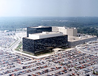
Fort George G. Meade is a United States Army installation located in Maryland, that includes the Defense Information School, the Defense Media Activity, the United States Army Field Band, and the headquarters of United States Cyber Command, the National Security Agency, the Defense Courier Service, Defense Information Systems Agency headquarters, and the U.S. Navy's Cryptologic Warfare Group Six. It is named for George G. Meade, a Union general from the U.S. Civil War, who served as commander of the Army of the Potomac. The fort's smaller census-designated place includes support facilities such as schools, housing, and the offices of the Military Intelligence Civilian Excepted Career Program (MICECP).

Fort Bliss is a United States Army post in New Mexico and Texas, with its headquarters in El Paso, Texas. Named in honor of LTC William Bliss (1815–1853), a mathematics professor who was the son-in-law of President Zachary Taylor, Ft. Bliss has an area of about 1,700 square miles (4,400 km2); it is the largest installation in FORSCOM and second-largest in the Army overall. The portion of the post located in El Paso County, Texas, is a census-designated place with a population of 8,591 as of the time of the 2010 census. Fort Bliss provides the largest contiguous tract of restricted airspace in the Continental United States, used for missile and artillery training and testing, and at 992,000 acres boasts the largest maneuver area. The garrison's land area is accounted at 1.12 million acres, ranging to the boundaries of the Lincoln National Forest and White Sands Missile Range in New Mexico. Fort Bliss also includes the Castner Range National Monument.

Pituffik Space Base, formerly Thule Air Base, is the United States Space Force's northernmost base, and the northernmost installation of the U.S. Armed Forces, located 750 mi (1,210 km) north of the Arctic Circle and 947 mi (1,524 km) from the North Pole on the northwest coast of the island of Greenland. Pituffik's Arctic environment includes icebergs in North Star Bay, two islands, a polar ice sheet, and Wolstenholme Fjord – the only place on Earth where four active glaciers join together. The base is home to a substantial portion of the global network of missile warning sensors of Space Delta 4, and space surveillance and space control sensors of Space Delta 2, providing space awareness and advanced missile detection capabilities to North American Aerospace Defense Command (NORAD), the United States Space Force, and joint partners.
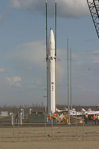
Ground-Based Midcourse Defense (GMD) is the United States' anti-ballistic missile system for intercepting incoming warheads in space, during the midcourse phase of ballistic trajectory flight. It is a major component of the American missile defense strategy to counter ballistic missiles, including intercontinental ballistic missiles (ICBMs) carrying nuclear, chemical, biological or conventional warheads. The system is deployed in military bases in the states of Alaska and California; in 2018 comprising 44 interceptors and spanning 15 time zones with sensors on land, at sea, and in orbit. In 2019, a missile defense review requested that 20 additional ground-based interceptors be based in Alaska.
Fort Slocum, New York was a US military post which occupied Davids Island in the western end of Long Island Sound in the city of New Rochelle, New York from 1867 to 1965. The fort was named for Major General Henry W. Slocum, a Union corps commander in the American Civil War.

Fort Greely is a United States Army launch site for anti-ballistic missiles located about 100 miles (160 km) southeast of Fairbanks, Alaska. It is also the home of the Cold Regions Test Center (CRTC), as Fort Greely is one of the coldest areas in Alaska, and can accommodate cold, extreme-cold, and temperate-weather tests depending on the season. It is named in honor of Major General Adolphus Greely.
Fort Totten is a former active United States Army installation in the New York City borough of Queens. It is located on the Willets Point peninsula on the north shore of Long Island. Fort Totten is at the head of Little Neck Bay, where the East River widens to become Long Island Sound. While the U.S. Army Reserve continues to maintain a presence at the fort, the property is now owned by the City of New York. The neighborhood has buses and served by MTA Regional Bus Operations Q13 and Q16 Buses.
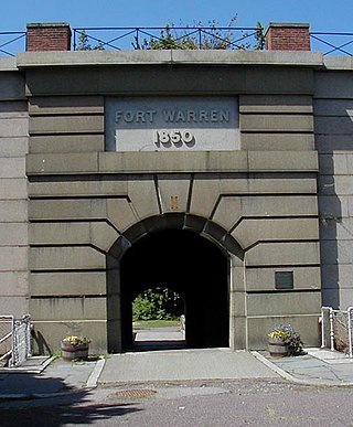
Fort Warren is a historic fort on the 28-acre (110,000 m2) Georges Island at the entrance to Boston Harbor. The fort is named for Revolutionary War hero Dr. Joseph Warren, who sent Paul Revere on his famous ride, and was later killed at the Battle of Bunker Hill. The name was transferred in 1833 from the first Fort Warren – built in 1808 – which was renamed Fort Winthrop.

Camp Hero State Park is a 754-acre (3.05 km2) state park located on Montauk Point, New York. The park occupies a portion of the former Montauk Air Force Station.

James A. Garfield Joint Military Training Center is an Ohio Army National Guard military base in the U.S. state of Ohio located between Ravenna and Newton Falls and adjacent to the village of Windham. It was previously known as Camp Ravenna Joint Military Training Center, the Ravenna Training and Logistics Site, and the Ravenna Army Ammunition Plant (RVAAP) and commonly known as the Ravenna Arsenal. Before its present status as a training facility for the Ohio National Guard, Camp James A. Garfield was a military ammunition production facility for the United States Army. As an arsenal, the facility was at peak operation during World War II and would serve as an ammunitions plant in various roles until 1992. Camp James A. Garfield remains an important part of the history and geography of Portage County. The facility occupies portions of Freedom, Windham, Charlestown, and Paris townships in Portage County, along with part of Braceville Township in Trumbull County.

Fort Fisher Air Force Station was a United States Air Force installation located on the Atlantic coast 0.8 miles (1.3 km) southwest of Kure Beach, North Carolina. Its primary mission was as a radar complex. It was closed on 30 June 1988 by the Air Force, and turned over to the Federal Aviation Administration (FAA).
Montauk Air Force Station was a US military base at Montauk Point on the eastern tip of Long Island, New York. It was decommissioned in 1981 and is now owned by the New York State Office of Parks, Recreation and Historic Preservation as Camp Hero State Park.

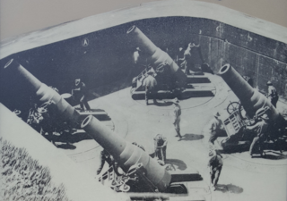
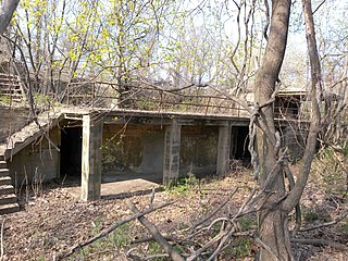
Fort Strong is a former U.S. Army Coast Artillery fort that occupied the northern third of Long Island in Boston Harbor. The island had a training camp during the American Civil War, and a gun battery was built there in the 1870s. The fort was built in 1893-1906 during the Endicott period of expansion in U.S. coast defense, and was part of the Coast Defenses of Boston. Formerly, it was also known as Long Island Military Reservation. Before World War I, a large station for handling submarine mines was added to the fort's defenses. Prior to World War I the fort was probably manned by over 1,000 soldiers. During World War II, two batteries of 3-inch guns defended channel minefields, but the big guns and other 3-inch batteries were decommissioned. Declared surplus in 1947, the fort served as a Nike missile site until 1961, and was redeveloped in 2005-2009 for a children's summer camp and later a homeless shelter. However, in 2014 the island's bridge was demolished due to safety concerns, and all activity ended.

Highlands Air Force Station was a military installation in Middletown Township near the borough of Highlands, New Jersey. The station provided ground-controlled interception radar coverage as part of the Lashup Radar Network and the Semi-Automatic Ground Environment network, as well as providing radar coverage for the Highlands Army Air Defense Site. The site's 240 acres (97 ha) is now the Rocky Point section in Hartshorne Woods Park of the Monmouth County Parks System.

Fort Heath was a US seacoast military installation for defense of the Boston and Winthrop Harbors with an early 20th-century Coast Artillery fort, a 1930s USCG radio station, prewar naval research facilities, World War II batteries, and a Cold War radar station. The fort was part of the Harbor Defenses of Boston and was garrisoned by the United States Army Coast Artillery Corps. The fort's military structures have been replaced by a residential complex, including the luxurious Forth Heath Apartments, and recreation facilities of Small Park, which has both a commemorative wall and an historical marker for Fort Heath.

Fort Drum is a U.S. Army military reservation and a census-designated place (CDP) in Jefferson County, near the western border of northern New York, United States. The population of the CDP portion of the base was 12,955 at the 2010 census. It is home to the 10th Mountain Division.
The 251st Coast Artillery was a coast artillery regiment in the California National Guard, constituted in 1924 as a harbor defense regiment for the 9th Artillery District and re-designated in 1930 as an antiaircraft regiment. It served in World War II in that capacity.
References
- 1 2 3 Shalal-Esa, Andrea (31 January 2014). "Pentagon to further study four possible East Coast missile defense sites". Reuters . Retrieved 2014-03-16.
- ↑ Atkinson, Scott (26 June 2019). "Fort Drum picked as site for east coast missile defense". WWNY . Retrieved 2020-01-18.